Rio Grande
In mid-2001, a sandbar formed at the mouth of the Rio Grande, and for the first time in recorded history, the river failed to empty into the Gulf of Mexico. Workers dredged the obstruction. It reformed almost immediately. This was not a freak event but a symptom: the Rio Grande is over-appropriated, meaning more people claim rights to its water than the river actually carries. Only twenty percent of its flow reaches the sea. The fourth longest river in the United States -- known as the Rio Bravo del Norte in Mexico, and To Ba'aadi in Navajo -- rises in Colorado's San Juan Mountains and traces a path through deep gorges, ancient pueblos, desert cities, and international borders before arriving, often exhausted, at the Gulf. Two nations, three U.S. states, and several Mexican states depend on its water. There is not enough for all of them.
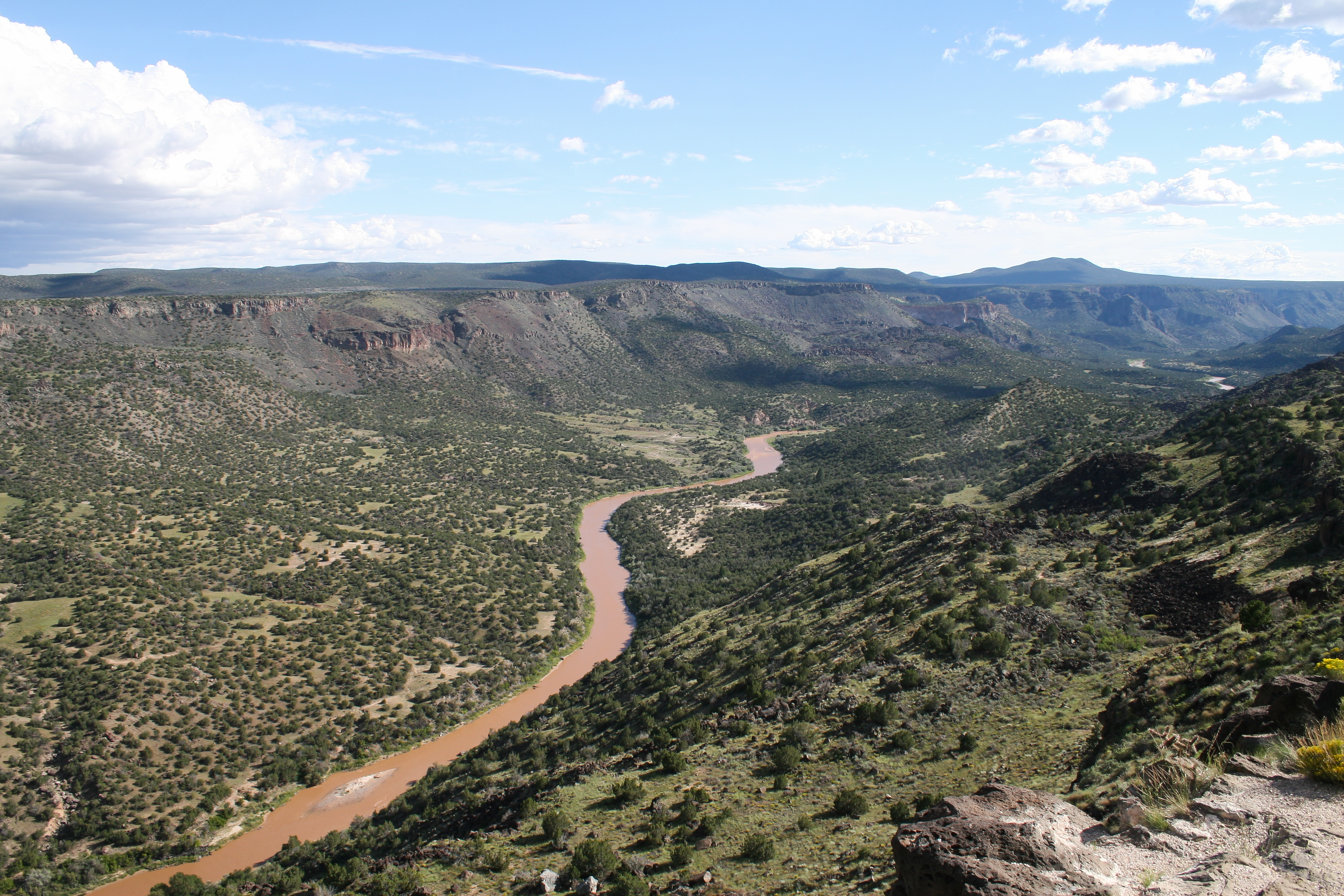
Born in the San Juans
The Rio Grande forms at the base of Canby Mountain in Colorado's San Juan Mountains, just east of the Continental Divide. From there it flows through the San Luis Valley and south into New Mexico, where it carves through the Rio Grande Gorge near Taos -- a dramatic volcanic rift visible from the air as a dark gash in the otherwise flat sagebrush plateau. At Espanola, the river collects additional water diverted from the Colorado River basin via the San Juan-Chama Project, a feat of engineering signed into law by President John F. Kennedy in 1962 and completed in 1971. The project tunnels water under the Continental Divide from tributaries of the San Juan River to Heron Reservoir, then into the Rio Chama and on to the Rio Grande. Albuquerque owns roughly three-quarters of that imported water -- a lifeline for a desert city of half a million people.
Thirteen Million Years in the Making
The sedimentary basins forming the modern Rio Grande Valley were not always connected. For millions of years, the basins created by the Rio Grande rift were isolated bolsons -- closed depressions with no external drainage, each containing a central playa lake that evaporated as fast as it filled. An axial river existed in the Espanola Basin as early as thirteen million years ago, but it drained into a dead-end playa in the southern Albuquerque Basin. By five million years ago, an ancestral Rio Grande draining the eastern San Juan Mountains had joined the ancestral Rio Chama. The full integration of these basins into a single river system reaching the Gulf of Mexico happened in relatively recent geological time. Paleo-Indian groups -- including the Belen and Cody cultures -- used the valley for seasonal migrations. The Oshara tradition began cultivating maize between 1750 and 750 BCE, and their settlements grew into the Tanoan and Keresan pueblos that still line the river today.
Conquest and Commerce
A Spanish naval expedition first charted the Rio Grande's mouth in 1519. In 1540, Francisco Vasquez de Coronado led an expedition from Nueva Galicia to the Tiwa pueblos along the river. On July 12, 1598, Don Juan de Onate established the colony of Santa Fe de Nuevo Mejico at the confluence of the Rio Grande and Rio Chama, adjacent to Ohkay Owingeh Pueblo. Three centuries later, the river became the disputed border between Mexico and the Republic of Texas, a disagreement that helped trigger the Mexican-American War in 1846. During the Civil War, the port of Bagdad at the river's mouth on the Mexican side became the Confederacy's only legitimate port, with European warships anchoring offshore to maintain its neutrality while bales of cotton were exchanged for military supplies. Over 200 steamboats operated on the lower Rio Grande in the nineteenth century, though Army engineers' recommendations to make the river navigable to El Paso were never acted upon.
The Water Wars
The modern story of the Rio Grande is a story of scarcity. The 1905 Rio Grande Project divided the river's waters between New Mexico and Texas and allocated a portion to Mexico -- the first time Congress directed the allocation of an interstate river. The 1938 Rio Grande Compact, negotiated after Texas sued New Mexico in 1935, governs water sharing between Colorado, New Mexico, and Texas to this day. A 1944 treaty formalized arrangements with Mexico. None of these agreements anticipated the twenty-first century's chronic drought. By 2022, water debt owed to Texas had ballooned from 31,000 to over 130,000 acre-feet. Elephant Butte Reservoir, the main storage facility, dropped to 5.9 percent of capacity. Albuquerque shut off its river diversion entirely in 2021, switching to groundwater. New Mexico began paying farmers to leave fields fallow. The section from Las Cruces to Ojinaga now frequently runs dry -- earning the grim nickname "The Forgotten River."
A River Still Setting Terms
Portions of the Rio Grande in New Mexico and Texas are designated as Wild and Scenic River, a federal protection that feels almost ironic given how thoroughly the rest of the waterway has been dammed, diverted, and depleted. Eight major dams punctuate its length: Rio Grande Dam, Cochiti, Elephant Butte, Caballo, Amistad, Falcon, Anzalduas, and Retamal. By the time the river reaches Presidio, Texas, little or no water remains. Below Presidio, the Rio Conchos -- a Mexican tributary -- restores flow, a reminder that the river's survival now depends on contributions from both sides of the border. In spring 2023, above-average snowfall sent high flows surging down the channel, flooding tributaries like the Jemez and Pecos Rivers. By that summer, after a failed monsoon season and record temperatures, the river went dry in Albuquerque for a second consecutive year. The Rio Grande gives, and the Rio Grande takes away -- on its own schedule, indifferent to the compacts and treaties that claim to govern it.
From the Air
The Rio Grande originates at 37.80N, 107.54W near Canby Mountain in the San Juan Mountains of Colorado. From the air, the river is a dramatic landscape feature visible for much of its length. Key visual landmarks: the Rio Grande Gorge near Taos (a deep volcanic rift cutting across the plateau), Elephant Butte Reservoir in southern New Mexico (often visibly low), and the river's role as the US-Mexico border from El Paso to the Gulf. Nearest airports to headwaters: Durango-La Plata County (KDRO), Alamosa San Luis Valley Regional (KALS). Along its course: Albuquerque International Sunport (KABQ), El Paso International (KELP), Laredo International (KLRD), Brownsville South Padre Island International (KBRO). Recommended viewing altitude: 10,000-15,000 ft AGL for gorge and valley context. The river corridor is an excellent VFR navigation reference across New Mexico.