Rio Grande del Norte National Monument
The Taos Plateau looks like it should go on forever -- a vast, sage-covered flatland stretching west from the town of Taos toward the Colorado border, interrupted only by the occasional dormant volcanic cone. Then the ground simply vanishes. The Rio Grande has carved a gorge up to 800 feet deep through this basalt tableland, a wound in the earth so abrupt that you can stand on the rim and see nothing of it until you are nearly at the edge. President Barack Obama proclaimed Rio Grande del Norte a national monument in 2013, assembling it from lands managed by the Bureau of Land Management. But the forces that created this landscape have been at work for millions of years, ever since the Rio Grande Rift began pulling the continent apart.
Where the Earth Pulled Apart
The monument sits within the Rio Grande Rift, one of the continent’s great tectonic features -- a zone where the Earth’s plates move away from each other rather than colliding. That separation opened cracks in the crust, and volcanoes rose through them. Successive lava flows cooled and filled the rift, building up the basalt platform that became the Taos Plateau. The Rio Grande, flowing south toward the Gulf of Mexico, cut downward through those accumulated layers of volcanic rock, carving the deep gorge that defines the monument. The result is a landscape of startling contrasts: flat sagebrush plains stretching to the horizon, then a sudden vertical drop into a narrow canyon where cottonwoods and willows crowd the riverbanks. Dormant volcanic cones dot the plateau to the west, silent reminders of the geologic violence that built this terrain.
Two Worlds Stacked Vertically
Step off the rim and you descend through distinct ecosystems packed into an 800-foot vertical drop. The plateau top is high desert -- sagebrush, open sky, and relentless wind at elevations well over a mile above sea level. Pinyon pine colonizes the gorge slopes and nearby hills. At the bottom, along the Rio Grande itself, willows and cottonwoods form green corridors fed by the river, and in the Wild Rivers area, the occasional ponderosa pine or Douglas fir appears -- species that normally grow at the higher elevations of the nearby Sangre de Cristo Mountains. Elk, mule deer, pronghorn, and bighorn sheep winter on the plateau. Cougars, bobcats, black bears, and coyotes follow. Brown trout, rainbow trout, and northern pike hold in the river’s deeper pools. The vertical compression of habitats means a single hike from rim to river can pass through ecological zones that elsewhere would be separated by hundreds of miles of horizontal distance.
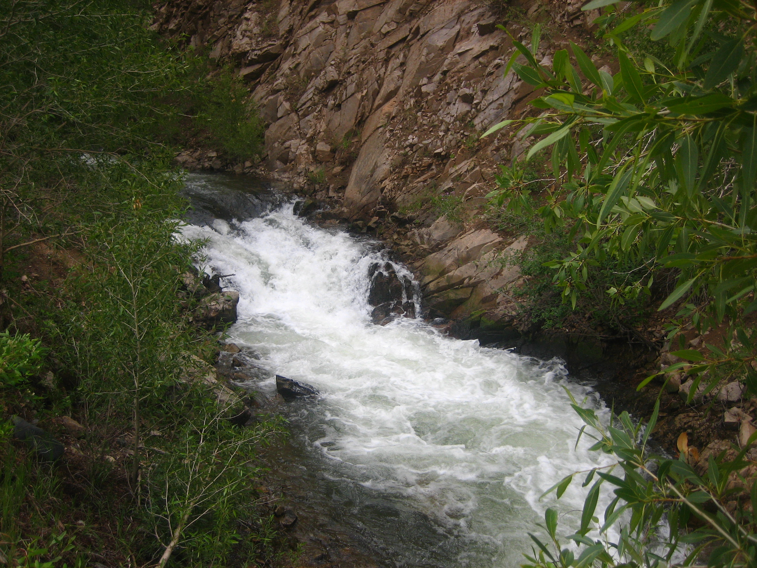
Wild Rivers and the Taos Box
The monument divides into two main recreation areas connected by the town of Taos. To the south, the Orilla Verde Recreation Area sits near the village of Pilar along NM 68, where the Rio Grande Gorge Visitor Center provides orientation. To the north, beyond the village of Questa, the Wild Rivers Recreation Area offers some of the most dramatic hiking in New Mexico. Trails here descend from the rim to the river through near-vertical terrain -- one drops 680 feet in a mile, another 760 feet in three-quarters of a mile, and a third descends 800 feet over 1.2 miles to the confluence of the Rio Grande and the Red River, at one point requiring stairs and a short ladder to navigate the cliffs. For whitewater rafters, the Taos Box is the prize: a 15-mile stretch of Class III-V rapids that ranks among the best whitewater runs in New Mexico, flowing from the upper gorge down to Orilla Verde. The nine-mile West Rim Trail connects the Rio Grande Gorge Bridge to Orilla Verde along the canyon’s edge, exposed to sun and wind the entire way.
The Bridge and the Plateau
The Rio Grande Gorge Bridge carries US 64 across the chasm west of Taos, and standing on it is the quickest way to grasp the monument’s scale. The gorge drops away on both sides, the river a thin silver line far below, the basalt walls dark and vertical. During summer, local vendors sell crafts at the bridge’s approaches while tourists lean over the railing. Beyond the bridge, the plateau stretches north and west toward the Colorado border, punctuated by dormant volcanic cones and inhabited by herds of grazing mammals. There are few trails or facilities out here -- just open space, big sky, and the knowledge that you are standing on cooled lava flows that once poured from vents in the Earth’s crust. Hidden along the gorge walls, natural hot spring pools sit on the banks of the Rio Grande, accessible only by a steep, rocky, unmarked trail. The springs are popular despite their isolation, a reward for those willing to scramble down into the rift.
High Desert, Deep Water
Rio Grande del Norte is a monument still being discovered. The BLM has been building visitor centers, campgrounds, trails, and roads over the past couple of decades, and the infrastructure is solid -- seven campgrounds at Orilla Verde, five at Wild Rivers, walk-in campsites along the river at the base of the gorge. Yet the monument remains largely unknown compared to the national parks that draw millions. Nearby Taos offers its famous art galleries, the historic Taos Pueblo -- one of the oldest continuously inhabited communities in North America -- and the Sangre de Cristo Mountains rising to the east. The monument itself asks for something simpler: stand at the rim, look down 800 feet to where the Rio Grande cuts its ancient path through volcanic rock, and consider the patience of water working against stone over geologic time. The rift is still active. The plates are still moving apart. The river is still cutting deeper.
From the Air
Located at 36.66N, 105.70W west of Taos, New Mexico. The gorge is dramatically visible from the air as a dark linear gash cutting through the pale Taos Plateau. The Rio Grande Gorge Bridge on US 64 is an excellent visual reference point. Recommended viewing altitude: 3,000-5,000 feet AGL. Nearest airports: Taos Regional (KSKX) approximately 10 nm east, Santa Fe Regional (KSAF) approximately 55 nm south, Albuquerque International Sunport (KABQ) approximately 100 nm south. High desert conditions; excellent visibility typical but watch for afternoon thunderstorms July-August.