Rio Platano Biosphere Reserve
There are no roads inside the Rio Platano Biosphere Reserve. To get anywhere, you take a pipante -- a dugout canoe hollowed from a single tree trunk, sometimes fitted with an outboard motor, sometimes not. The reserve covers 350,000 hectares of northeastern Honduras, protecting the entire watershed of the Rio Platano from its headwaters in the mountains to its mouth on the Caribbean coast. Together with the adjacent Bosawas Biosphere Reserve across the border in Nicaragua, it forms the largest contiguous forest in Latin America north of the Amazon. UNESCO inscribed it as a World Heritage Site in 1982, recognizing it under all four natural criteria -- a distinction shared by very few places on Earth.
The Last Great Rainforest of Central America
What survives here is what once blanketed most of the region. Tropical rainforest rises from coastal wetlands through lowland jungle to cloud-shrouded mountain ridges, sheltering toucans, howler monkeys, parrots, jaguars, rare butterflies, and sea turtles that nest along the Caribbean beaches. The Rio Platano itself winds through this canopy, its upper reaches hiding petroglyphs carved by people whose identity archaeologists are still piecing together. Somewhere in the jungle, stories persist of a "White City" -- well-preserved bright white stone buildings of unknown origin, far upriver. The site has never been formally excavated, and the few locals who know its approximate location guard that knowledge carefully. What is certain is that this forest, despite its apparent wildness, has been inhabited and shaped by human hands for millennia.
People of the Mosquitia
Over 2,000 indigenous people live within the reserve, maintaining traditional ways of life that predate European contact. The Miskito, Pech, and Garifuna communities along the coast and rivers are not relics of the past; they are living cultures adapted to one of the most challenging environments in the Americas. The village of Las Marias, a common starting point for travelers heading deeper into the reserve, operates a rotating guide system so that every family benefits from tourism income. A head guide -- the sacaguias -- assigns local guides to each group, and the prices are fixed. Attempting to circumvent this system creates conflict, because the arrangement reflects how the entire community has chosen to organize itself. In the coastal communities of Belen, Raista, and Plaplaya, the Garifuna share storytelling, drumming, and traditional casaba bread-making with visitors who arrive by motorized canoe.
A Heritage in Danger
In 2011, UNESCO placed the reserve on its List of World Heritage in Danger, and the threats have not receded. Illegal logging strips the forest canopy. Cattle ranchers clear land at the reserve's edges -- sometimes with money laundered by drug traffickers who use the remote Mosquitia as a transit corridor. Uncontrolled hunting depletes wildlife populations. Plans for large dams in the region threaten to alter the river systems that define the reserve's ecology. The dry season, from before Christmas through June, brings fewer mosquitoes but also easier access for those who exploit the land. Conservation here is not an abstraction debated in distant capitals; it is a daily negotiation between the people who live inside the forest and the pressures encroaching from outside it.
Getting There Is the Point
Reaching the reserve is itself an experience that filters for commitment. From La Ceiba, the journey involves a chicken bus to Tocoa, then a five-to-six-hour ride in the back of a pickup truck over rough roads to Batalla, where a narrow strait of water separates you from Palacios. From there, a collectivo canoe runs to Belen or Raista several times a week. Small aircraft fly from La Ceiba to airstrips at Palacios, Belen, and Puerto Lempira, but schedules are loose and seats are limited. There is no park entrance fee. The remoteness is not an obstacle to be overcome -- it is the reserve's greatest protection, the reason this forest still stands while so much of Central America's rainforest has fallen. Every hour spent in a dugout canoe, watching the jungle close in around the river, is an hour spent understanding why this place was worth saving.
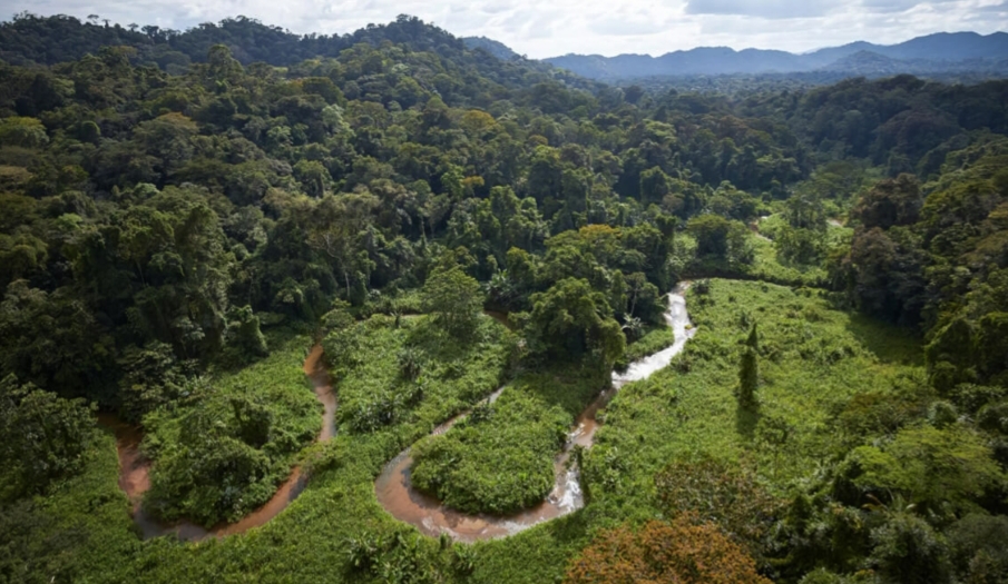
From the Air
Located at 15.25N, 84.73W in the Mosquitia region of northeastern Honduras. From altitude, the reserve appears as an unbroken expanse of rainforest stretching from coastal lowlands to interior mountains, bisected by the winding Rio Platano. Best viewed from 5,000-8,000 feet AGL, where the contrast between forest and cleared land at the reserve boundaries is dramatic. Small airstrips at Palacios, Belen, and Puerto Lempira serve the area. La Ceiba's Goloson International Airport (MHLC) is the nearest major airport, approximately 80 nm west.