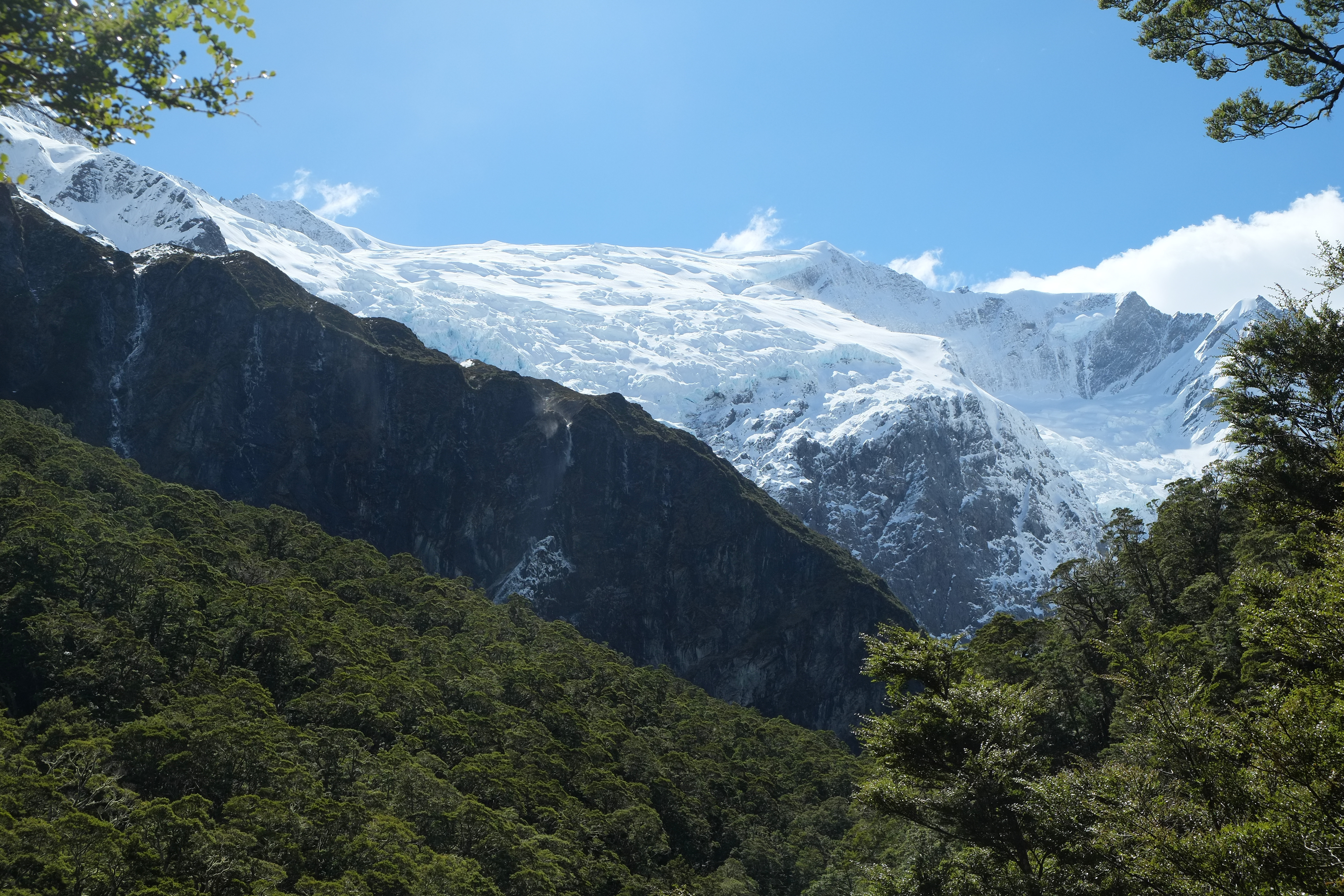
Rob Roy Glacier
Twenty thousand years ago, the Rob Roy Glacier did not hang. It filled its entire valley, poured into the Matukituki Glacier below, merged with the Wanaka Glacier, and together they formed a continuous river of ice that ground down the Clutha Valley nearly to where Cromwell stands today. What remains is a fraction - a hanging glacier draped across the headwalls of the Rob Roy Valley, its lowest edge breaking over a cliff at around 1,500 metres, ice blocks occasionally calving off the face and tumbling to the valley floor far below. About 20,000 people a year make the walk to see it, making Rob Roy one of the most accessible glaciers in New Zealand's South Island and one of the most dramatic.
Ice on the Edge
The most prominent section of Rob Roy Glacier covers the northwestern slopes of the valley, clinging to the mountainside below the 2,644-metre Rob Roy Peak. Ice extends from just below the summit down to a bench high on the valley wall, where it abruptly runs out of mountain and breaks over the cliff's edge. The glacier also wraps around the headwalls encircling the valley head, covering most of the upper rock faces except on the eastern side, where the bordering peaks fall just short of 2,000 metres - not high enough to sustain permanent ice. In spring, the warming temperatures trigger small avalanches and send seracs crashing from the glacier's terminal face. The larger blocks do not stop at the cliff edge; they tumble and shatter all the way to the valley floor, an event spectacular to witness from the safety of the lookout on the opposite side.
A Walk Worth the Drive
Getting to Rob Roy Glacier requires a kind of escalating commitment. First comes the drive from Wanaka along the Mount Aspiring Road - sealed at first, then 30 kilometres of gravel, the last 10 kilometres a fair-weather-only track that crosses seven fords. The Raspberry Creek car park at road's end marks the start of the walking track, which takes three to four hours return. The path begins on farmland, crosses the Matukituki River on a swing bridge, then follows Rob Roy Stream uphill, climbing 330 metres through beech forest into a sub-alpine basin. The lookout at the end sits just above the tree line, facing across the valley to where the glacier towers on the opposite wall. It is, apart from the drive, the most easily accessible glacier in the region - no crampons, no ropes, no mountaineering experience required. Just sturdy boots and a willingness to drive a rough road.
What the Ice Age Left Behind
The scale of what has been lost becomes clear only when you understand what was once here. During the last glacial maximum, the Rob Roy Glacier was merely a tributary feeding into a system so vast that ice filled the entire Matukituki Valley. That glacier merged with others flowing from the surrounding peaks, combining into the Wanaka Glacier that carved out the basin now occupied by Lake Wanaka. The ice continued south and east, grinding through the Clutha Valley - one of the longest river valleys in New Zealand - reaching nearly to present-day Cromwell, some 60 kilometres from the Rob Roy Valley. Europeans arrived in the Matukituki Valley in the 1870s and began farming on land that ice had shaped and abandoned. Today, the remnant glacier hangs above their successors' paddocks, a fragment of a system that once reshaped the entire landscape.
The Sound of Falling Ice
From the lookout, the experience is primarily one of sound and scale. The glacier face across the valley appears close enough to touch but is hundreds of metres away - a trick of the clear mountain air and the sheer size of the ice. When a serac breaks free, the crack echoes off the valley walls before the ice even begins to fall. Waterfalls cascade from the glacier's melt, threading white lines down the dark rock. In the quiet moments between calving events, the only sounds are the stream below and the wind moving through the valley. A wingsuit flier completed a descent from Rob Roy Peak in 2015, adding a briefly human note to a landscape that operates on geological time. The glacier does not care about spectators. It has been retreating since the ice age ended, and it will continue whether anyone watches or not.
From the Air
Located at 44.455S, 168.75E within Mount Aspiring National Park, 9km south of Mount Aspiring / Tititea. Rob Roy Peak rises to 2,644m (8,675ft) with the glacier visible on its northwestern slopes. The glacier's terminal face breaks over a cliff at approximately 1,500m elevation. The Matukituki Valley provides the visual corridor from the east. Nearest airports: Wanaka (NZWF) approximately 50km east via road, Queenstown (NZQN) further southeast. The Raspberry Creek car park area at the valley floor is at roughly 480m elevation. Expect mountain turbulence and variable weather. The glacier and surrounding ice fields are visible from altitude in clear conditions.