Rock of Gibraltar
The Greeks and the Phoenicians called it the boundary of the known world. One of the two Pillars of Hercules, the northern sentinel guarding the entrance to the Mediterranean, the Rock of Gibraltar has accumulated names and meanings for millennia: Mons Calpe to the Romans, Jebel Tariq to the Moors who invaded in 711 AD, and for generations of English speakers, a byword for immovability itself. At 426 meters high and just 27 kilometers from the African coast, this monolithic slab of Jurassic limestone has been fortress, nature reserve, and geological wonder since before recorded history.
Deep Time in Stone
The Rock's geology is itself a story of upheaval. Its sedimentary layers are overturned -- the oldest strata sit on top of the youngest, a result of the immense tectonic forces that folded and faulted the limestone. The Catalan Bay Shale Formation contains echinoid spines, belemnite fragments, and Early Jurassic ammonites, evidence of the shallow seas that covered this region nearly 200 million years ago. Calcite dissolves slowly in rainwater, and over geological time this process has hollowed the Rock into a labyrinth of more than 100 caves. At Forbes' Quarry on the north face, a Neanderthal woman's skull was discovered in 1848 -- eight years before the famous type specimen was found in the Neander Valley, though its significance went unrecognized until later. On the eastern face, Gorham's Cave preserves evidence of Neanderthal habitation and is now a UNESCO World Heritage Site.
Fortress of Empires
The Moorish Castle, whose substantial construction began in 1160 AD under Almohad Sultan Abd al-Mu'min -- though Berber chieftain Tariq ibn-Ziyad first landed on the rock that bears his name in 711 -- marks the beginning of over 750 years of Islamic rule. The 17th-century historian Al-Maqqari wrote that Tariq burned his ships upon landing. The Tower of Homage, built of brick and a concrete so hard it is called tapia, still stands. After the Christian reconquest and the British capture in 1704, the Rock was besieged fourteen times -- the last and greatest during the American Revolutionary War, when a garrison of 5,000 held out for nearly four years. The Great Siege Tunnels, carved by hand through solid limestone beginning in 1782, pioneered underground military engineering. By the Second World War, the tunnel network had expanded so massively that the Rock could shelter 16,000 men with a year's worth of supplies. A secret plan, Operation Tracer, even called for hiding a radio team inside sealed tunnels in case the Germans captured the fortress.
The Apes' Rock
About 300 Barbary macaques roam the upper reaches of the Rock -- the only wild primate population in Europe. Their origins are debated: they may descend from North African animals brought to Spain, or they may be a remnant of populations that spread across southern Europe during the Pliocene, up to 5.5 million years ago. A famous legend holds that as long as the apes remain on the Rock, Gibraltar will stay under British control. Churchill reportedly ordered their numbers maintained during the war. The macaques share their territory with approximately 40 percent of Gibraltar's land area, declared a nature reserve in 1993. Barbary partridges breed on the slopes, lesser kestrels nest in the cliffs, and roughly 250,000 raptors funnel through the Strait each year, making the Rock an Important Bird Area and one of Europe's great migration bottlenecks.
Solid as the Rock
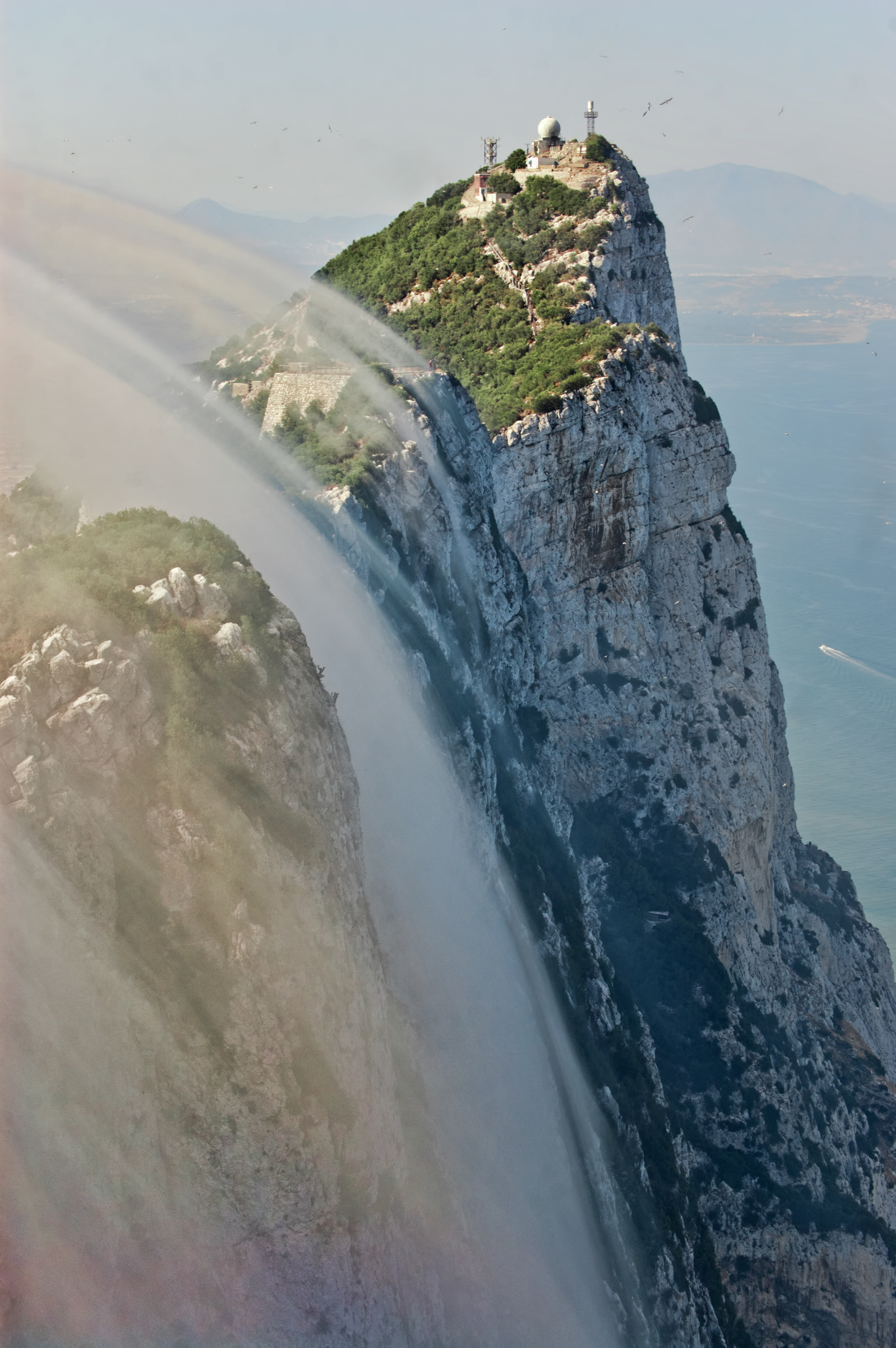
The phrase has entered the language: solid as the Rock of Gibraltar. It is the logo of Prudential Financial, a metaphor in the Gershwin standard "Love Is Here to Stay," and the motto of the territory itself -- Nulli Expugnabilis Hosti, "No Enemy Shall Expel Us." From the air, the Rock's double identity is unmistakable. The western face, comparatively gentle, holds the city of Gibraltar with its narrow streets and harbor. The eastern face drops in sheer cliffs and wind-blown sand slopes to the sea, its roads carved through tunnels and along precarious ledges. Between these two faces, inside millions of tons of limestone, lie the tunnels, the caves, the bones of Neanderthals, and the shells that fired on Spanish galleons -- layers of human and geological history compressed into a single, unmistakable silhouette.
From the Air
Located at 36.13°N, 5.34°W at the southern tip of the Iberian Peninsula. The Rock rises 426 m (1,398 ft) and is unmistakable from any direction. Best viewed from the east to see the sheer cliff face, or from the north to see the isthmus and border crossing. Nearest airport: Gibraltar International (LXGB), whose runway crosses the main road connecting Gibraltar to Spain. The Strait of Gibraltar (14 km wide) and the African coast are visible to the south.