Rogers Pass
Rogers Pass cuts through the Selkirk Mountains of British Columbia at 1,330 meters elevation - a gap that made the transcontinental railroad possible and has been killing people ever since. The pass receives over 10 meters of snowfall annually; avalanches sweep the slopes constantly. Between 1885 and 1911, avalanches killed over 200 Canadian Pacific Railway workers. The railroad eventually tunneled beneath the pass; when the Trans-Canada Highway was built in 1962, engineers faced the same challenge. Today, Rogers Pass operates the world's largest mobile avalanche control program, with military artillery and helicopter bombardment triggering controlled slides to protect travelers. The highway still closes for avalanche control; the mountains still win sometimes. Rogers Pass is a monument to human stubbornness against terrain that doesn't want roads.
The Discovery
The Canadian Pacific Railway needed a route through the Selkirk Mountains to complete the transcontinental line. Major A.B. Rogers, a surveyor, found the pass in 1881 after years of searching. The railway was built through in 1885, completing the line. Rogers' discovery earned him a $5,000 bonus check; he initially refused to cash it, preferring to frame it. He eventually cashed it only when Van Horne promised him a gold watch as a souvenir. What Rogers found was a natural corridor through brutal terrain - but the snow that accumulated in the surrounding peaks posed dangers no one fully anticipated.
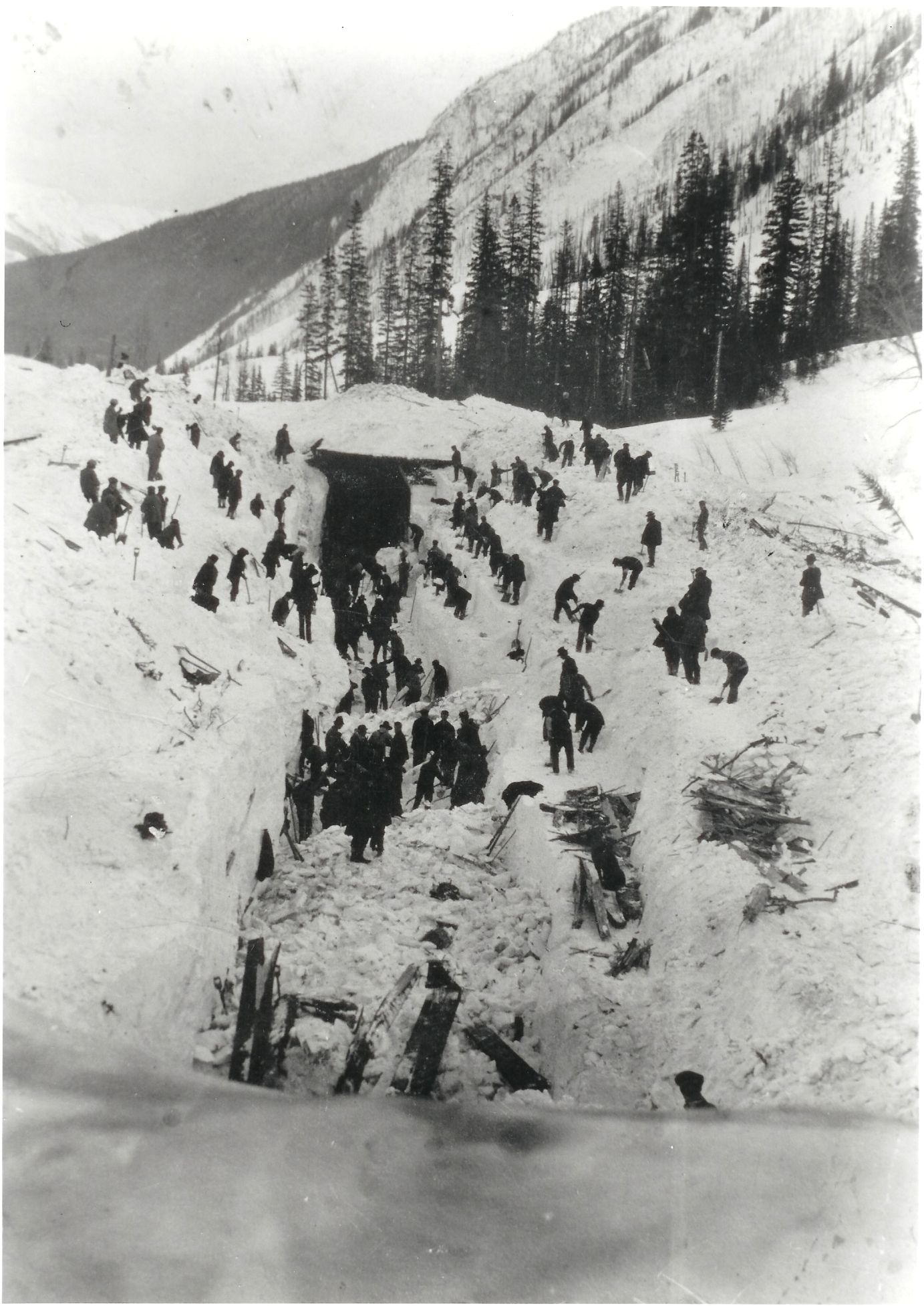
The Deaths
The Rogers Pass section of the CPR was the most dangerous on the entire transcontinental route. Avalanches swept down regularly, burying tracks, demolishing snowsheds, and killing workers. The worst disaster came on March 4, 1910, when a crew was clearing avalanche debris. A second avalanche struck, killing 58 men - Canada's worst avalanche disaster. The victims included many Japanese Canadian workers. Over 200 people died in avalanches along this stretch between 1885 and 1911. The railroad eventually gave up; the Connaught Tunnel (1916) and later Mount Macdonald Tunnel (1988) routed trains beneath the pass rather than over it.
The Highway
When the Trans-Canada Highway was completed through Rogers Pass in 1962, engineers knew the avalanche risk. They built snowsheds - concrete tunnels through which the highway passes beneath avalanche paths. But not every slide zone could be covered. Instead, Parks Canada developed the world's most sophisticated avalanche control program. When snow conditions warrant, the highway closes and crews fire 105mm howitzer shells into known slide areas, triggering controlled avalanches that clear the slopes before natural releases threaten traffic. The program fires over 1,500 rounds annually. The highway still closes for control work and occasionally for unexpected slides.
The Control
The Rogers Pass avalanche control program uses military artillery, helicopter bombing, and Gazex (remotely triggered gas exploders) to manage over 130 avalanche paths. Control missions can close the highway for hours. Parks Canada staff monitor weather, snow conditions, and slope stability continuously. When conditions warrant, they request road closure and begin firing. The bombardment can be heard for miles; the resulting avalanches roar down slopes and across the highway corridor. After clearing, the highway reopens. The system isn't perfect - slides occasionally catch vehicles - but it has dramatically reduced casualties compared to the railroad era.
Visiting Rogers Pass
Rogers Pass is located on the Trans-Canada Highway (Highway 1) in Glacier National Park (Canada), approximately 80 kilometers east of Revelstoke and 150 kilometers west of Golden. The Rogers Pass Discovery Centre provides exhibits on railroad history, avalanche control, and mountain ecology. The Abandoned Rails Trail follows the old CPR route past snow sheds and the 1910 avalanche site. Glacier National Park offers hiking, including approaches to the Illecillewaet Glacier. Winter travel through Rogers Pass requires winter tires; be prepared for highway closures during avalanche control or severe weather. Calgary is 300 kilometers east; Vancouver is 600 kilometers west. The pass is crossed year-round, but winter showcases the avalanche terrain that makes this passage so challenging.
From the Air
Located at 51.30°N, 117.52°W in the Selkirk Mountains of British Columbia. From altitude, Rogers Pass is visible as a gap in the mountain ranges - the Selkirks to the west, the Purcells to the east. The Trans-Canada Highway threads through the pass; snowsheds are visible as covered sections. The terrain is extreme - steep avalanche slopes rising on both sides, glaciated peaks above. Revelstoke is 80 kilometers west; Golden is 150 kilometers east. The avalanche paths that make the pass so dangerous are visible as treeless chutes on the mountainsides. In winter, fresh avalanche debris is often visible across the slopes - evidence of the ongoing battle between highway and mountain.