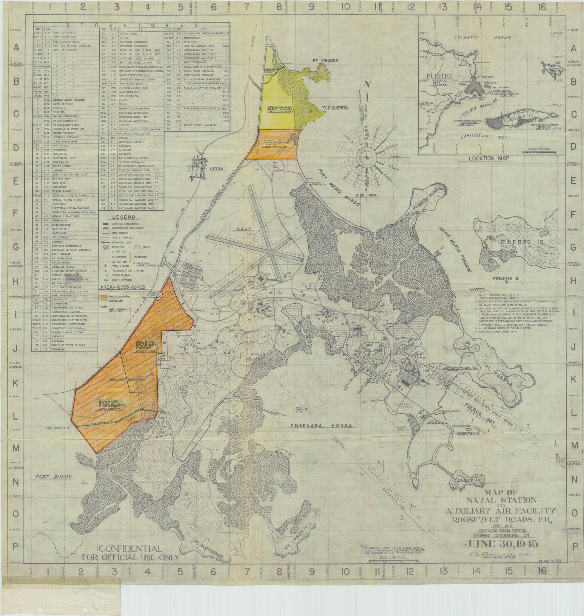
Roosevelt Roads Naval Station
In 1919, a young Franklin D. Roosevelt toured Puerto Rico's eastern coast and liked what he saw. Twenty-one years later, as president with a world war approaching, he ordered a naval base built on that same terrain in Ceiba. The base that bore his name -- Roosevelt Roads, nicknamed "Rosy Roads" by generations of sailors -- would grow into the largest naval installation in the world by area, serve as the staging ground for Caribbean operations for six decades, close abruptly in 2004, sit largely abandoned for twenty years, and then reopen again. Few military installations have traced so many reversals of fortune, and none have so thoroughly reflected the shifting relationship between the United States and Puerto Rico.
Built for a War, Ready for the Next
Roosevelt ordered the base's creation in 1940, as Nazi Germany swept across Europe and the possibility of threats to the Western Hemisphere grew real. In 1941, Congress appropriated $50 million to develop a protected anchorage in the waters between Puerto Rico and Vieques. Navy Secretary Frank Knox formally named the area Roosevelt Roads on May 15, 1941. By August, another $21.97 million was authorized for fleet anchorage facilities.
Construction moved fast. Within the industrial area, crews built a drydock, a bombproof power plant with four-foot-thick concrete walls housing two 5,000-kilowatt steam generators, a sewage pumping station, and a machine shop. The drydock, built dry and first flooded in July 1943, was dedicated in February 1944 as the Bolles Drydock, honoring Captain Harry A. Bolles, a Civil Engineer Corps officer killed in Alaska during the war. Upgraded to Naval Station status in 1957, Roosevelt Roads became the nerve center for U.S. military operations in the Caribbean, its primary mission the tactical support of training exercises at the Naval Training Range on nearby Vieques.
Vieques and the Reckoning
The base's fate was always intertwined with Vieques. For decades, the Navy used the smaller island as a live-fire bombing range, a practice that drew increasing opposition from Puerto Ricans who lived on and near Vieques. The relationship between the military and the community was fraught: Fort Bundy, part of Roosevelt Roads, crossed onto Vieques territory, and the M3 military mission stationed at the base managed operations extending well beyond its fences. While the Navy pointed to counter-narcotics work and disaster-response capability -- Seabees stationed at Camp Moscrip since 1969 cleared roads and restored power within hours of Hurricane Georges in 1998 -- residents pointed to contamination, health concerns, and the use of their home as a target.
In January 2003, Admiral Robert J. Natter acknowledged the inevitable: with the Vieques training range closing, Roosevelt Roads had lost its primary reason for existence. Congress ordered the facility shut within six months. The base closed on March 31, 2004, displacing nearly 1,200 active-duty personnel. It closed faster than any other military installation on U.S. soil in several decades -- a speed that reflected less urgency than a desire to move on from a controversy that had embarrassed the Navy for years.
The Long Emptiness
The closure hit Ceiba and surrounding communities hard. Over 1,000 local contractors lost their jobs, and an estimated $300 million in annual direct disbursements vanished from the regional economy. Roughly 30% of the former base's property was transferred to the Puerto Rico government and its municipalities. Forty percent became a wetlands preserve. The rest was offered at public auction.
For years, various plans surfaced and stalled. In 2009, approximately 2,900 acres were marketed through the Base Realignment and Closure Program. In 2012, SpaceX considered Roosevelt Roads as a possible private launch site but chose elsewhere. In 2018, Governor Ricardo Rossello's administration repurposed part of the facility as a launching port for ferries to Vieques and Culebra. When the COVID-19 pandemic struck in 2020, there were calls to reopen the base's former hospital. Meanwhile, the Puerto Rico Ports Authority took over Jose Aponte de la Torre Airport, which had served the base, operating it as a public-use facility. The base sat in a kind of limbo -- too valuable to ignore, too complicated to redevelop.
The Return
In 2017, Hurricane Maria provided a preview of what Roosevelt Roads could still be. A joint Army National Guard and Marine expeditionary team established a staging base at the shuttered station, receiving around-the-clock airlifts and dispatching helicopter teams to hospitals across the island. Air Force contingency response squadrons, the 1st Armored Division Aviation Brigade, and the 101st Airborne Division's medical evacuation unit all operated from the site. It was the first major military activity at Roosevelt Roads since the 2004 closure.
Then, in 2025, the base returned to active military operations. Environmental remediation, runway restoration, and infrastructure renovation preceded an official reactivation on November 14, 2025. Reports and satellite imagery confirmed the presence of military aircraft, including F-35 Lightning II jets. The reactivation reflected evolving U.S. strategic priorities in the Caribbean -- but for Puerto Ricans, it reopened familiar questions. In September 2025, local senators introduced a resolution to evaluate the base's impact, citing both security needs and the economic contribution that the station once provided. The base that FDR envisioned in 1919, ordered built in 1940, and saw closed in 2004 was operating again, its story still unfinished.
From the Air
Located at 18.25N, 65.64W in Ceiba, on Puerto Rico's eastern coast. The base includes Jose Aponte de la Torre Airport (TJRV/NRR, IATA: NRR), with a runway visible from altitude as a large airfield complex on the coastal plain northeast of the Sierra de Luquillo. The installation occupies a prominent coastal position between the main island and Vieques (visible approximately 8 nm to the southeast). From cruising altitude, the base is identifiable by its extensive runway infrastructure, former naval pier facilities, and the contrast between developed military areas and surrounding wetlands preserve. Luis Munoz Marin International (TJSJ/SJU) is approximately 30 nm west-northwest. Vieques (Antonio Rivera Rodriguez Airport, TJVQ/VQS) is clearly visible to the southeast. The waters between Puerto Rico and Vieques -- the protected anchorage FDR envisioned -- are prominent from altitude.