Royal Natal National Park
When the British Royal Family visited in March 1947, they gave this park a name that stuck. But the Amphitheatre needed no royal endorsement - this five-kilometer wall of basalt cliff had been stunning Zulu herdsmen and Boer trekkers for centuries before King George VI arrived. The escarpment rises 1,000 meters above the valley floor in a single sweep, its face catching light from dawn to dusk in ways that make photographers weep with frustration at their inadequate equipment. Below it, the Tugela River gathers strength before launching itself over the edge in five successive drops totaling 948 meters - by some measures, the highest waterfall on Earth. This is the northern gateway to the uKhahlamba-Drakensberg UNESCO World Heritage site, where ancient San rock art shares the mountains with bushbuck and baboons, and the weather changes faster than you can consult a forecast.
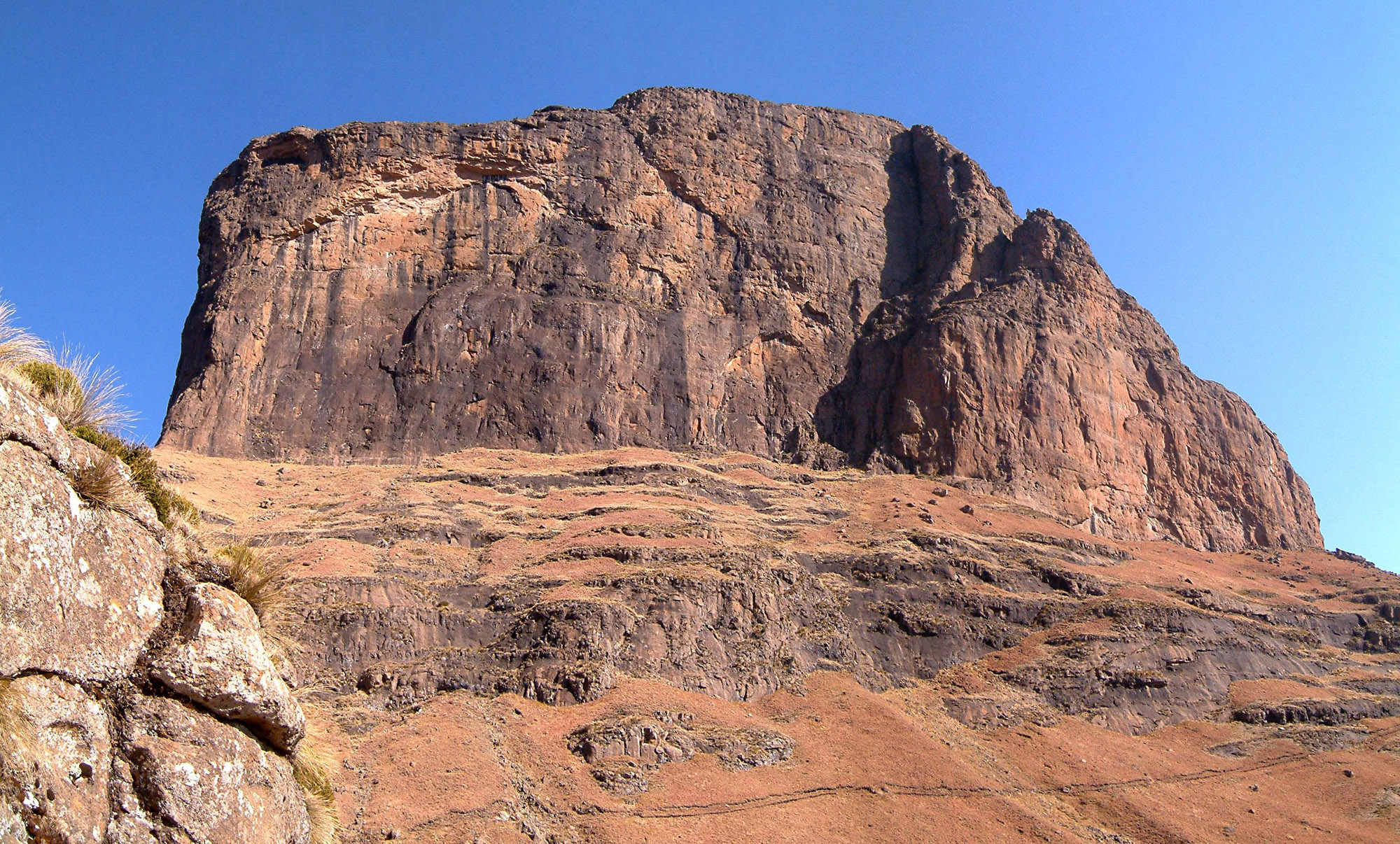
The Amphitheatre
The Amphitheatre is the Drakensberg's signature feature - a crescent-shaped basalt cliff stretching five kilometers along the escarpment edge, its face rising sheer for a thousand meters above the valley. From below, the scale is impossible to grasp; the cliff seems close enough to touch yet remains an hour's drive plus a full day's hike away. From the top, South Africa spreads beneath you like a map, and the Free State and Lesotho borderlands vanish into distance.
The cliff marks the edge of the Lesotho Plateau, where volcanic basalt has eroded more slowly than the sedimentary rock below. The result is geological drama: the Sentinel Peak at 3,165 meters, the Eastern Buttress, Devil's Tooth, and other formations that climbers have been ascending since the 1920s. The Amphitheatre is not the Drakensberg's highest point - that honor goes to peaks further south - but it may be its most beautiful.
The Tugela's Leap
The Tugela Falls drops 948 meters in five successive cascades, plunging from the escarpment top to the valley floor. Whether this makes it the world's highest waterfall depends on how you measure: the total drop exceeds Angel Falls in Venezuela, but the Venezuelan cascade is uninterrupted while the Tugela pauses between its five steps. Waterfall enthusiasts debate the distinction endlessly. The Tugela pays no attention.
Visit in late summer - March through May - when snowmelt and autumn rains have the river running full. The dry winter months reduce the falls to mere wisps of spray, and photographs taken then disappoint viewers who expected thundering water. The hike to the base takes most of a day; the chain-assisted climb to the top offers views that justify the effort. Weather permitting. Weather rarely permits for long.
Walking the Trails
The park offers walks ranging from easy strolls to multi-day expeditions. The Cascades trail follows the Tugela River through pristine bushveld to a waterfall that rewards minimal effort. The Gorge trail climbs into the valley where the Tugela enters the park, offering progressively more challenging terrain and better views. The Sentinel Peak hike takes all day but puts you on top of the Amphitheatre.
The mountain rescue register at the Information Centre is not optional for serious hikes. Weather in the Drakensberg changes with terrifying speed - morning sunshine becomes afternoon thunderstorm becomes zero-visibility mist, all within hours. The standard advice is sensible: if caught in thick mist, stop and wait. Eventually it lifts. The alternative - stumbling off cliffs you can't see - appeals to no one. Baboons pose the other hazard: they have learned that hikers carry food, and a troop of baboons demanding snacks is more intimidating than it sounds.
Mountain Kingdom Border
The park borders Lesotho, the mountain kingdom entirely surrounded by South Africa. The escarpment that creates the Amphitheatre is also the international frontier - stand at the top of the Tugela Falls and you're looking into a different country. The plateau beyond is the Lesotho Highlands, a roof of Africa where winter brings snow and summer brings lightning storms that crack across the basalt like artillery.
This is not easy border country. No roads cross here; only foot trails connect the valleys. The San people who left rock paintings throughout the park moved freely across what would become national boundaries. Their art - hunting scenes, spiritual imagery, records of contact with Nguni peoples - survives in overhangs and caves throughout the Drakensberg. Some paintings date back thousands of years. The artists are gone, but their work remains.
Practical Realities
Royal Natal is 48 kilometers from the nearest petrol station in Bergville. The park shop stocks basics - boerewors, beer, washing powder - at fair prices, but serious provisioning requires advance planning. Accommodation ranges from chalets to campsites; the Thendele Upper Camp puts you closest to the Amphitheatre views. A daily conservation fee applies: R50 for adults, R25 for children. Entry is by smartcard only at main gates.
The drive in from the N3 passes through rural villages where children and livestock cross at will. Slow down. The speed limit in the park is academic since you'll spend more time walking than driving. The nearest airport is in Durban, three hours south by car. The Spioenkop battlefield - scene of a disastrous British defeat in the Second Boer War - lies 80 kilometers toward Ladysmith. History layers thick in these hills.
From the Air
Royal Natal National Park (28.75S, 29.00E) sits at the northern end of the Drakensberg escarpment in KwaZulu-Natal province, South Africa, at the border with Lesotho. The Amphitheatre - a 5km-long crescent of basalt cliff rising 1,000m above the valley - is the primary visual landmark, unmistakable from altitude. The Tugela Falls (948m total drop) cascade over the escarpment edge. The park sits at approximately 1,400m elevation at the valley floor, with the escarpment top reaching 3,000m+. No airstrip in the park; nearest significant airports are King Shaka International (FALE/DUR) in Durban, 200km southeast, and Bloemfontein Airport (FABL/BFN), 180km northwest. Terrain is extremely mountainous with rapid elevation changes. Weather is highly variable - clear mornings frequently become afternoon thunderstorms with sudden mist and visibility loss. Snow possible April-September. The escarpment creates significant turbulence and windshear.