Rugby, North Dakota
The stone obelisk at the intersection of US Highway 2 and North Dakota Highway 3 makes a bold claim: this is the geographic center of North America. Three flags -- American, Canadian, and Mexican -- flank the monument like witnesses to the assertion. The trouble is, it is not true. Modern calculations accounting for cartographic projection distortions place the actual center roughly 105 miles to the southwest, in a town called Center, North Dakota. The irony is almost too perfect. But Rugby, population 2,509, has never let the math get in the way of a good story, and the monument erected in 1931 still draws visitors off the highway, curious to stand at what feels like the middle of an entire continent.
A Little England on the Plains
Rugby owes its existence to the Great Northern Railway, which platted the town in 1886 at the junction where a branch line to Bottineau met the main transcontinental route. The railroad promoters named it Rugby Junction after the town of Rugby in Warwickshire, England, and it was hardly alone in this exercise of nostalgia. Strung along the Great Northern line between Devils Lake and Minot was an entire constellation of English place names: Berwick, Leeds, Knox, Norwich, Penn, Surrey, Churches Ferry, Tunbridge, and York. When the settlement grew into a proper city, the Junction was quietly dropped. The name stuck, though, carrying a faint echo of English midlands across the North Dakota prairie -- a reminder that the people who built these railroad towns were still tethered to the places they had left behind.
The Monument That Moved
In 1931, Rugby erected a rock obelisk marking what it proclaimed to be the Geographical Center of North America. For forty years the monument stood in place, a roadside attraction before the term existed. Then in 1971, the expansion of US Highway 2 forced the obelisk to a slightly different location -- a geographic center that had already shifted, literally and figuratively. The U.S. Geological Survey has noted that Rugby sits at some distance from the actual calculated center of the continent, and even the USGS designation carries no official status. A 2017 New York Times article pointed out that Center, North Dakota, has the stronger mathematical claim. None of this has diminished Rugby's commitment to the idea. The monument still stands, the flags still fly, and the town still prints the claim on its promotional materials. Sometimes a good story outlasts the facts that inspired it.
Wheat Fields and Threshing Machines
North Dakota's first permanent settlers arrived in 1812 from the Earl of Selkirk's colony in neighboring Rupert's Land, bringing with them farming techniques more sophisticated than those practiced by many of their American contemporaries. They adopted advanced methods and machinery early, and traces of that agricultural heritage survive in Rugby's Pioneer Village, where restored implements include an early McCormick Deering threshing machine. The village preserves the material culture of an era when wheat was the currency of the northern plains, and the rhythm of planting and harvest governed everything from social calendars to rail schedules. Pierce County remains agricultural country, and the open fields stretching in every direction from Rugby still define the landscape more than any building or monument.
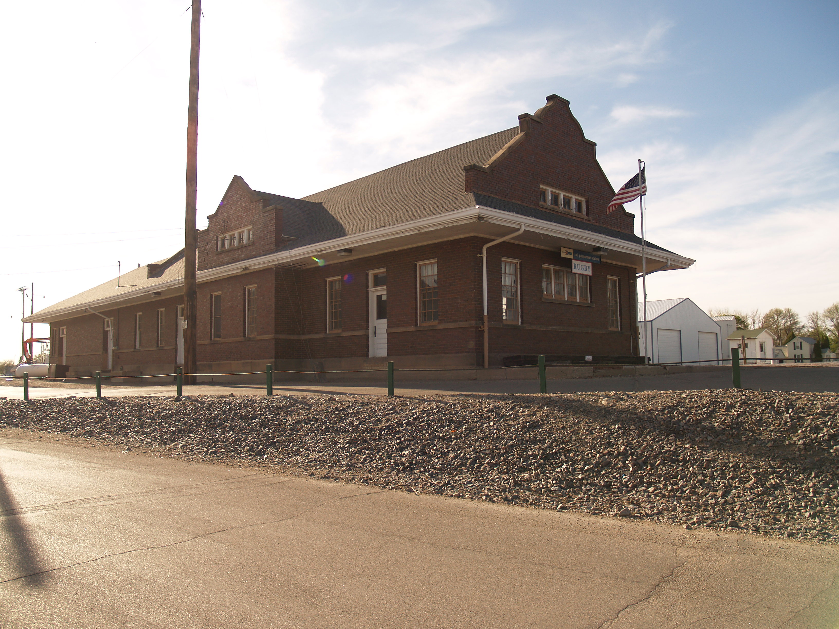
The Empire Builder Stops Here
Amtrak's Empire Builder, the once-daily train running between Portland and Seattle in the west and Chicago in the east, still stops at Rugby. The station was originally built by the Great Northern Railway in 1907 and has undergone multiple renovations, most recently in 2022. It is a modest building for a modest stop, but its continued operation connects Rugby to a tradition of transcontinental rail travel that predates the interstate highway system by decades. The Empire Builder follows one of the most scenic rail routes in the country, crossing the northern plains where the sky is so vast it can feel oppressive. Rugby sits at the midpoint of that crossing, a place to step off the train, stretch your legs, and contemplate the fact that you are standing -- more or less, give or take a hundred miles -- in the middle of a continent.
From the Air
Located at 48.365°N, 99.990°W at approximately 1,545 feet MSL on the flat North Dakota prairie. Rugby is visible from altitude at the intersection of US Highway 2 (running east-west) and ND Highway 3 (running north-south). The Great Northern Railway line passes through town. Minot lies 66 miles west along US-2. Devils Lake is approximately 65 miles east. The nearest airports include Rugby Municipal Airport (18D) for general aviation. The terrain is remarkably flat agricultural land with minimal obstructions. Best viewed from 3,000-5,000 feet AGL where the grid pattern of roads and the town's position at the highway intersection are clearly visible.