Ruins of Loropéni
In 1324, Mansa Musa of the Mali Empire made his famous hajj to Mecca, distributing so much gold along the way that he crashed the metal's price across North Africa and the Middle East for a decade. The gold had to come from somewhere. Scattered across the savannas of what is now southern Burkina Faso, a network of stone-walled fortresses controlled the extraction and trade of that gold, feeding it northward through the trans-Saharan routes that made empires. The best preserved of these fortresses stands near the small town of Loropeni. Its laterite walls still rise six meters high, enclosing 11,000 square meters of ground that archaeologists have barely begun to excavate. Who built them, and precisely when, remains an open question.
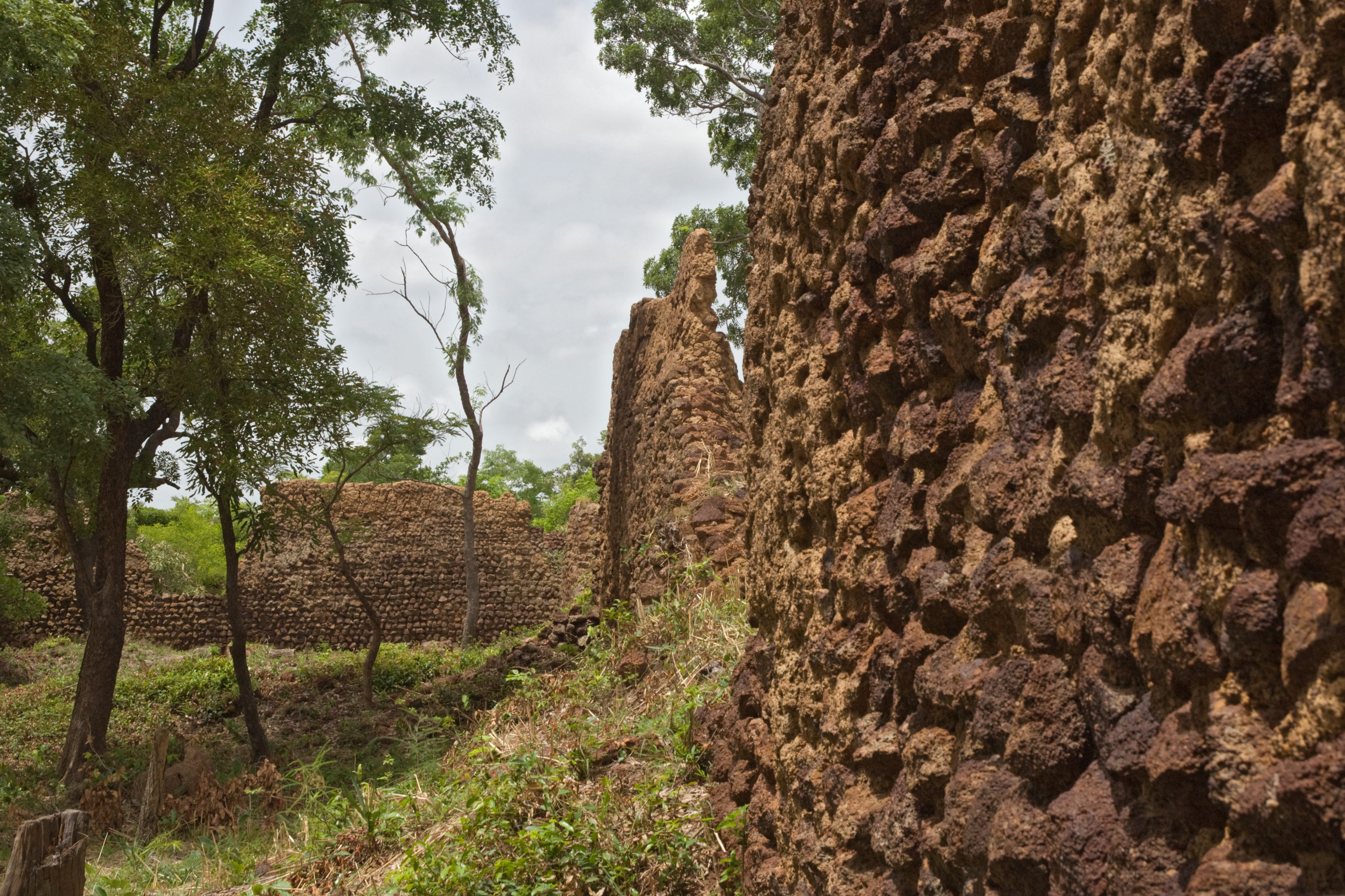
Walls That Outlasted Empires
Radiocarbon dating places the walled enclosure at Loropeni at least as far back as the 11th century, though it reached its peak between the 14th and 17th centuries. The fortress is the best preserved of roughly ten similar stone enclosures in the Lobi area, themselves part of a larger constellation of perhaps one hundred such structures scattered across the region. Built from laterite, a rust-red stone abundant in the local soil, the walls are imposing even in ruin. Six meters tall and thick enough to withstand siege, they enclose a space roughly the size of two and a half acres. The sheer scale of construction raises questions that the archaeological record has not yet answered: what community organized the labor, quarried the stone, and maintained these defenses for centuries?
Gold Roads and Desert Crossings
The fortress's purpose almost certainly involved gold. Loropeni sits within a gold-bearing region that connected, indirectly, to the trans-Saharan trade routes terminating at Timbuktu and Gao to the north and the ancient city of Djenne to the northwest. The Ghana Empire and later the Mali Empire controlled major gold mines at Bambuk and Boure, channeling wealth through their capitals. Loropeni's fortified settlements appear to have served a parallel function farther south: securing the extraction and movement of gold from local mines before it entered the broader trade networks. The imposing height of the walls has led some researchers to theorize they were built specifically to protect gold stores, though this conclusion rests on circumstantial evidence. What is clear is that when the trans-Saharan trade collapsed and commerce shifted to European coastal posts, these inland fortresses lost their reason for being.
Peoples Who Passed Through
Multiple groups have been linked to Loropeni, but none definitively identified as its builders. The Lohron or Kulango people occupied the settlement during its period of greatest prosperity. The Gan or Kaan people, a minority group whose homeland includes the site, have oral traditions claiming their king Tokpa Farma intended to relocate his capital from Obire, eight kilometers away, to Loropeni. However, revised timelines suggest the Kaan occupied the fortress rather than constructed it. The Lobi people arrived later, pushed northward by the expanding Ashanti kingdom to the south, crossing the Mouhoun River to reach lands they considered their ancestral territory. By the time they arrived, the fortress was already in decline. The site was abandoned entirely in the early 19th century, and the surrounding bush gradually swallowed the walls until only their upper reaches remained visible above the tree canopy.
Burkina Faso's First World Treasure
In 2009, UNESCO inscribed the Ruins of Loropeni as Burkina Faso's first World Heritage Site, recognizing the fortress as testimony to a powerful and sustained trans-Saharan gold trade. The inscription brought international attention but also highlighted the site's vulnerability. Environmental pressures, including increasing rainfall variability and extreme temperature cycles, are eroding the laterite walls. Dense vegetation encroaches on the ruins, both protecting them from the elements and obscuring them from study. Large portions of the site remain unexcavated, their secrets locked beneath centuries of accumulated soil and root systems. The Committee of Protection and Management for the Ruins of Loropeni has worked to balance preservation with sustainable development for the surrounding community, but the archaeological mystery at the site's heart persists. Somewhere beneath the red earth of southern Burkina Faso, the full story of who built these walls, and why, waits to be unearthed.
From the Air
Located at 10.31°N, 3.56°W in southern Burkina Faso near the town of Loropeni. The ruins are largely obscured by dense vegetation from altitude but the cleared areas around the fortress walls may be visible at lower altitudes. Nearest significant airport is Gaoua, the provincial capital of Poni Province. Bobo-Dioulasso Airport (ICAO: DFOO) is the nearest major airport, approximately 200 km to the northwest. Best viewed at 2,000-4,000 feet where the laterite walls contrast with surrounding green vegetation. The landscape is rolling savanna with scattered tree cover.