Rumbek
Before South Sudan had a permanent capital, it had Rumbek. After the 2005 peace agreement ended the Second Sudanese Civil War -- a conflict that killed an estimated two million people -- the Sudan People's Liberation Movement chose this town in the Bahr el Ghazal region as the temporary seat of government for the autonomous south. The choice was practical rather than prestigious: Rumbek was centrally located, relatively accessible, and had survived. Eventually Juba was selected as the permanent capital, and Rumbek settled back into its role as the headquarters of Lakes State. But the brief moment when this small savanna town held the political center of gravity for what would become Africa's newest country left a mark that its residents have not forgotten.
A Town Between Wars
Rumbek sits at 420 meters elevation on the A43 highway, roughly 377 kilometers northwest of Juba by road. Like most South Sudanese towns, it suffered enormous infrastructural damage during the civil war. Roads crumbled, buildings were gutted, and the institutions that held daily life together simply ceased to function. When peace came, the scale of reconstruction was staggering. The Sudanese People's Liberation Movement's decision to base the southern government here in 2005 brought an influx of attention and resources, but the deeper work of rebuilding -- roads, hospitals, schools -- would take far longer. Some of those road repairs began after 2005 and continue to this day, a reminder that the distance between a peace agreement and a functioning society is measured in decades, not years.
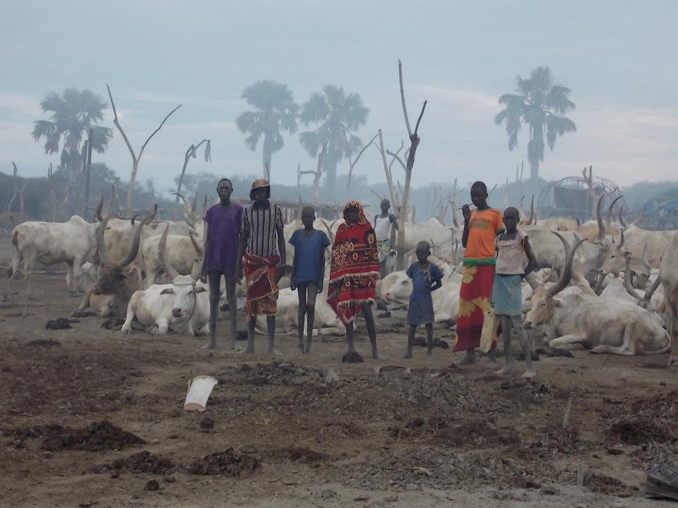
The Dinka Heartland
The population of Rumbek County was estimated by the United Nations at about 82,500 in 2004. The Dinka Agar constitute roughly 60 percent of the population, with Dinka Gok making up another 30 percent. Bongo and Jur-Bel communities account for the remainder. This demographic composition reflects the broader pattern across Lakes State, where the Dinka are the dominant ethnic group and cattle herding remains central to cultural identity and economic life. The town anchors a network of smaller roads that connect to Yirol to the east and Durbuoni to the north, while the main A43 continues northwest to Wau. Rumbek Airport, a small facility with scheduled airline service and charter providers, offers a lifeline to the outside world when roads become impassable during the wet season.
Freedom Square and Faith
At the center of Rumbek lies Freedom Square, an outdoor public venue where the town gathers for civic events and celebrations. It was here that thousands turned out to celebrate South Sudan's independence on July 9, 2011 -- a day that represented the culmination of decades of struggle. Rumbek Holy Family Cathedral stands as another anchor of community life; the Roman Catholic Diocese of Rumbek has served the region through war and peace alike. The town also hosts the Salva Kiir Women International Hospital and Lakes State Hospital, though healthcare access remains severely limited across the region. Rumbek University, one of just four public universities in all of South Sudan, represents an investment in a future that the town's residents are still building from the ground up.
Heat, Rain, and Resilience
Rumbek's climate is defined by extremes. March temperatures regularly reach nearly 38 degrees Celsius, and the annual mean sits at 27.8 degrees -- hot by almost any standard. The wet season arrives around May and runs through October, dumping nearly 850 millimeters of rainfall across roughly 77 precipitation days. August alone contributes about 160 millimeters. When the rains come, humidity jumps from a parched 31 percent in February to 74 percent, and the savanna landscape transforms from brown to green almost overnight. The town receives over 2,675 hours of sunshine annually, spread fairly evenly across the year. In this landscape of scorching dry seasons and drenching wet ones, the people of Rumbek continue the work of building a country that has known more years of war than peace.
From the Air
Rumbek is located at 6.80N, 29.68E, at 420 meters elevation in the flat savanna of Lakes State, South Sudan. From altitude, look for the town along the A43 road corridor between Juba (southeast) and Wau (northwest). Rumbek Airport (ICAO: HJRK) has a visible airstrip adjacent to the town. The surrounding landscape is flat East Sudanian savanna with seasonal flooding. Tropical savanna climate with excellent visibility in dry season (December-March) and reduced visibility during wet season (May-October).