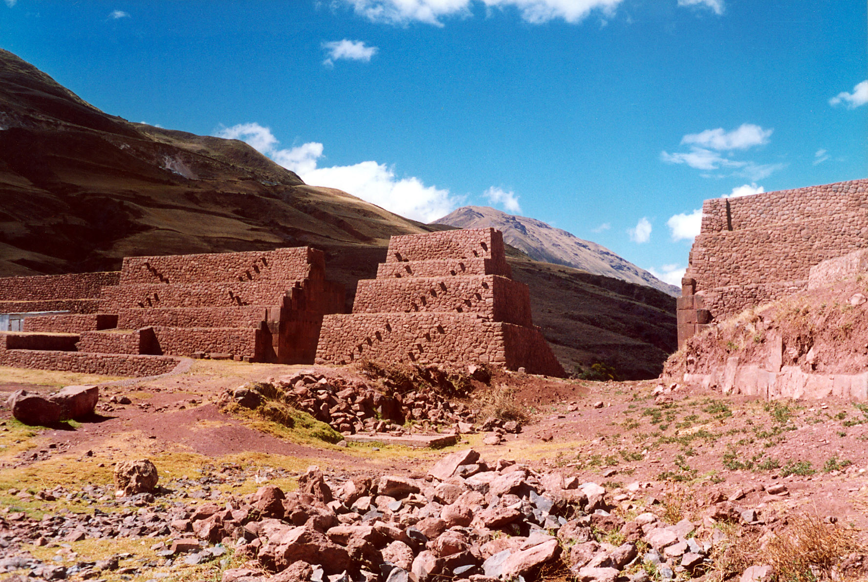
Rumicolca
Look closely at the stonework and you can read a thousand years of history in two layers. The lower courses are rough, functional, utilitarian -- the work of the Wari civilization, which flourished between roughly 550 and 900 AD as the first state-level society in Peru's Sierra region. Above and around them, precisely fitted Inca masonry encases the older structure like a stone veneer, smooth and interlocking without mortar. This is Rumicolca, whose name in Quechua -- rumi meaning stone, qullqa meaning storehouse -- barely hints at the debates that still surround its purpose.
A Legend of Water and Marriage
Cusco folklore preserves its own explanation for Rumicolca. According to the story, the Wari people of the nearby city of Pikillaqta -- one of the earliest urban settlements in highland Peru -- faced a chronic water shortage. A great Wari leader offered his daughter's hand in marriage to whichever man could solve the problem. Two suitors stepped forward, one from Cusco and one from Puno. The man from Cusco won by building a canal from the Laguna de Huacarpay to Pikillaqta, and where the canal needed to cross a wide gap, he constructed what the legend calls the first and largest aqueduct in ancient Peru. Whether or not the romantic details hold up, the core of the story -- that Rumicolca was built to carry water to Pikillaqta -- aligns with the most current archaeological understanding.
Gate or Aqueduct?
For years, scholars debated whether La Portada de Rumicolca -- "the Gateway" -- was primarily a gate or an aqueduct. The gate theory held that the Wari originally built it to mark the boundary of their territory, and that the Inca later expanded it into a formal checkpoint between the northern suyu of Cusco and the southern suyu of Puno. Since the structure sits on the main highway between these two regions, travelers would have passed through and paid tolls. This theory attempted to explain why the structure shows two distinct construction phases: crude Wari stonework wrapped in finely carved Inca veneer. The aqueduct theory, now considered more likely, argues that the Wari built the structure to carry water from its inception. Paleohydrologist Kenneth Wright concluded that the canal running along La Portada is not a retrofit but part of the original design.
Two Empires in One Wall
What makes Rumicolca remarkable is not just its age or its engineering but the visible conversation between two civilizations separated by centuries. The Wari, who urbanized Pikillaqta and created the aqueduct sometime before 900 AD, left behind functional but rough stonework -- effective, practical, built to carry water across a gap. When the Inca absorbed this region into their empire centuries later, they did not demolish the structure. Instead, they improved it, adding their signature precisely cut stone veneer over the Wari foundations. The result is a palimpsest in stone: two engineering traditions, two aesthetic philosophies, fused into a single structure. The site sits east of Lake Huacarpay near the archaeological complexes of Pikillaqta and Chuqi Pukyu, in the Quispicanchi Province of the Cusco Region.
Crossroads of the Suyus
Whether built primarily as an aqueduct or a gate, Rumicolca occupied a strategic position on the Inca road network. The main highway from Cusco ran southeast through this point toward Puno and Lake Titicaca, one of the most important routes in the empire. The Inca divided their domain into four suyus -- quarters that radiated from Cusco like compass points -- and Rumicolca stood at the boundary between Chinchaysuyu to the north and Collasuyu to the south. Travelers, traders, and military columns would have passed through this narrow gap between the mountains, perhaps pausing to pay tribute. The aqueduct may have served a dual purpose: delivering water to the settlement at Pikillaqta while also channeling traffic through a controlled passage point, solving two problems with a single structure of stone.
From the Air
Located at 13.62S, 71.71W in the Cusco Region of Peru, approximately 30 km southeast of Cusco along the road toward Puno. The site sits in a valley near Lake Huacarpay, adjacent to the larger archaeological site of Pikillaqta. From the air, the structure appears as a stone gateway spanning a gap in the terrain between hillsides. Cusco's Alejandro Velasco Astete International Airport (SPZO) is the nearest major airfield. Terrain is high-altitude valley at approximately 3,200 meters elevation.