Saint Julien Memorial
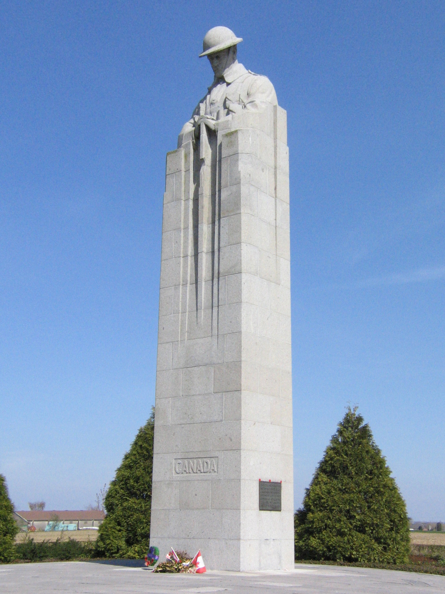
He has no eyes. Eleven metres up, on a column of grey granite at a country crossroads two miles north of Ypres, a stone soldier stands at rest with his head bowed over his rifle. The carved face is in shadow, the helmet pulled low, the hands folded on the butt of an inverted weapon - the 'arms reversed' posture that soldiers take at military funerals, when a comrade is lowered into the ground. He is brooding, the sculptor said, and that is the name everyone has used ever since. The Brooding Soldier stands at what was once called Vancouver Corner, looking out across the fields where, on 22 April 1915, a yellow-green chemical cloud reached the Canadian line - and where the line did not break.
The Forty-Eight Hours
The 1st Canadian Division had been on the Western Front for a few weeks when the gas came. They held the line east of Saint-Julien, where the British and French sectors met. The chlorine cloud, released from German cylinders to their north on the late afternoon of 22 April 1915, struck French Territorial and Algerian troops, who broke and ran - few human beings could have done otherwise. The cloud opened a gap of roughly 8,000 yards in the Allied front. The Canadians on its southern shoulder did not run. Over the next two days they counter-attacked into Kitcheners' Wood with the bayonet, dug new positions, took a second gas cloud directly into their faces on the morning of 24 April with handkerchiefs soaked in urine pressed against their mouths, and held until reinforcements arrived. In those forty-eight hours, 6,035 Canadians became casualties - one man in every three who went into the line. About 2,000 of them were killed.
The Competition
When the war ended, the Imperial War Graves Commission granted Canada eight battlefield sites to memorialise - five in France, three in Belgium. The Canadian Battlefields Memorials Commission, formed in November 1920, decided to hold a design competition. The winning entry would be used at all eight sites. The first prize went to the Toronto sculptor Walter Seymour Allward, whose vast pylons and allegorical figures would eventually rise at Vimy Ridge. Second place went to a Saskatchewan architect named Frederick Chapman Clemesha, himself a wounded veteran of the war, whose entry was a single column topped by a brooding soldier. The Commission decided Allward's grand design suited Vimy and reserved the second-place design for the other seven sites. In the end, for reasons of cost and judgement, only one Clemesha memorial was built. They put it at Saint-Julien, at the place where the gas reached the Canadians.
What Clemesha Made
The Brooding Soldier rises from a circular flagstone terrace. Around it are gardens of cedar - tall trees clipped into the shape of artillery shells standing on their bases, and lower bushes trimmed to look like the puff of shell-bursts. The detail is almost obsessive. The figure at the top is a Canadian infantryman, head bowed, hands resting on a downward-pointing rifle: a soldier mourning his dead. Clemesha had been a lieutenant; he had been gassed himself in the war; he had seen what it did. The 'arms reversed' posture he sculpted is the formal gesture of military mourning, used at funerals and at the laying of wreaths. The column is 11 metres tall, plain on three sides, with an inscription on the fourth. Visible from miles around in the flat Flemish farmland, it is one of the most affecting war memorials of the twentieth century because it does so little - one figure, one gesture, no allegory.
Soil From Home
When the memorial was being laid out in the early 1920s, soil was brought to it from every Canadian province. The gardens at Saint-Julien grow in earth from across the country - from the Maritime provinces, from Quebec and Ontario, from the prairies, from the Pacific coast - so that the ground where the Brooding Soldier stands carries something of every Canadian who came here to fight. It is a small gesture, easy to miss, but it is the kind of detail that the men of 1915 would have understood. Many of them had been in Canada months earlier; the Canadian Expeditionary Force was largely a citizen army, raised quickly, sent across the Atlantic to a continent most of them had never seen. To be buried, or remembered, in Belgian soil mixed with the soil of the prairies they came from was something the planners thought worth doing.
Vancouver Corner
The crossroads where the memorial stands - the intersection of the modern N313 with Zonnebekestraat - was known to British and Canadian troops as Vancouver Corner. It is not clear who named it, or when. Canadian troops, asked the names of unfamiliar Flemish crossings, named them after places they knew. Vancouver Corner is the only one of those wartime names still on Belgian signposts. The memorial was unveiled on 8 July 1923 by Prince Arthur, Duke of Connaught and Strathearn, the third son of Queen Victoria. The address was given by French Marshal Ferdinand Foch, who had commanded the Allied armies at the end of the war and who had once said that the Canadian stand at Second Ypres was one of the most magnificent efforts of the whole war. A replica of Clemesha's Brooding Soldier was incorporated into the war cenotaph at Victoria Park in Regina, Saskatchewan, in 1926 - a slightly smaller version of his original, brought home to the province where he lived.
Standing Beneath It
Most days, even in summer, you can be alone here. Saint-Julien is now Sint-Juliaan and is a small village; Vancouver Corner is a working country crossroads with passing tractors and the occasional tour coach. The memorial sits on a low rise on the corner, the cedars dark against the sky, the bowed head of the soldier visible from the road as you approach. There are bilingual plaques explaining what happened in the fields around. Many visitors are descendants - Canadians on a battlefield tour, or grandchildren of men who fought here, looking for a name in the next village over at Tyne Cot or further north at Langemark German Cemetery. The Brooding Soldier asks nothing of them. He keeps his head down. The wind in the cedars and the wind across the wheat sound the same as they did in April 1915, before the cloud arrived.
From the Air
The Saint Julien Memorial stands at 50.8995 N, 2.9406 E, at the intersection of the N313 and Zonnebekestraat on the northern edge of the village of Sint-Juliaan, roughly 6 km northeast of Ypres centre. The 11-metre column is visible from the air in clear conditions; the surrounding cedar gardens give it a darker, distinct footprint against the surrounding farmland. Approach from the southwest at 1,000-2,000 ft AGL to retrace the route the chlorine cloud took on 22 April 1915, drifting south and southwest from the German lines near Langemark. Wevelgem (EBKT) is 25 km southeast and is the nearest civil field. Tyne Cot Commonwealth War Cemetery is 4 km east of the memorial and Langemark German Cemetery 4 km northwest - both are useful aerial landmarks. The Flemish coast can produce sudden low cloud; check ceilings carefully.