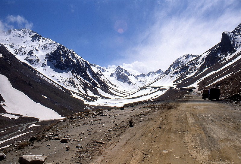
Salang Pass
For most of recorded history, getting from Kabul to northern Afghanistan meant a three-day journey over the Shibar Pass -- a long, circuitous route that exhausted travelers and animals alike. The Salang Pass offered something faster but far more dangerous: a direct line through the Hindu Kush at 3,878 meters, where the air thins and winter storms can descend without warning. Travelers and armies have been making that calculation for centuries, weighing speed against survival, and the mountain has collected its toll from those who chose wrong.
The Hinge of Afghanistan
The Salang Pass sits on the border between Parwan Province to the south and Baghlan Province to the north, and its geographic position makes it one of the most consequential mountain crossings in Central Asia. To the south lies Charikar and, beyond it, Kabul. To the north, the road descends toward Mazar-i-Sharif and Kunduz, the major cities of Afghanistan's northern plains. Just to the west stands the Kushan Pass, and together the two crossings have provided the most direct connections between the Kabul region and Tokharistan -- the ancient name for the lands north of the Hindu Kush -- since before the age of written records. The Salang River originates near the pass and flows southward, carving the valleys that early travelers followed upward toward the ridge.
Soviet Concrete Through Ancient Rock
In 1958, Soviet engineers began drilling into the mountain beneath the pass, and by 1964 they had completed the Salang Tunnel -- a 2.67-kilometer bore at approximately 3,400 meters elevation that allowed vehicles to cross the Hindu Kush without climbing to the exposed summit. The tunnel transformed Afghan logistics. What had been a 72-hour journey between Kabul and the north became a 10-hour drive, saving roughly 300 kilometers. But the infrastructure came with a political price: when the Soviet Union invaded Afghanistan in 1979, the tunnel it had built became the primary supply route for its own occupation forces. The pass and tunnel carried Soviet convoys south and, eventually, carried them back north in retreat. The road that connected Afghanistan also made it easier to control.
Destruction and Resurrection
In 1997, during the Afghan civil war, forces loyal to Ahmad Shah Massoud destroyed the tunnel to prevent Taliban fighters from advancing through it. The Hindu Kush once again became an obstacle instead of a corridor. Five years later, in 2002, the Russian Ministry of Emergency Situations organized repairs, and crews completed the reconstruction within a month -- a testament both to the tunnel's relative simplicity and to its irreplaceable importance. Without it, Afghanistan's north and south are functionally separate countries, divided by some of the most forbidding terrain on earth. The tunnel reopened, and traffic resumed -- far more of it than the passage was designed to handle.
The Mountain's Recurring Violence
The Salang Pass does not forgive overconfidence. In February 2010, a series of avalanches struck the approach roads in rapid succession, burying miles of highway and trapping vehicles inside the tunnel. Rescue crews from the Afghan National Army and NATO deployed helicopters to extract at least 2,500 stranded people, but by the time the road reopened on February 12, more than 160 bodies had been recovered. Radio Free Europe described the scene: the first avalanche blocked the tunnel entrance, and subsequent slides trapped vehicles in what reporters called a "deadly avalanche zone." It was not the first time -- avalanches had killed at least ten people in January 2009 -- and it would not be the last. The pass remains open year-round in theory, but winter closures from heavy snowfall are frequent, and each season brings the question of whether the road will hold or the mountain will reassert itself.
From the Air
Located at 35.31N, 69.04E in the Hindu Kush range of central Afghanistan. The pass sits at 3,878 meters (12,723 feet), with surrounding peaks rising higher. The winding approach roads on both sides are visible from altitude as pale switchbacks against dark rock and snow. In winter, heavy snow cover makes the pass and tunnel approaches particularly dramatic from the air. Nearest airports are Bagram Airfield (OAIX), approximately 60 km south, and Kabul International (OAKB), approximately 100 km south. Exercise extreme caution due to high terrain -- minimum safe altitude in this area should account for peaks exceeding 4,500 meters. Turbulence and rapidly changing weather are common.