Where the Rocks Remember the Sea
The rocks at Salt Point look like they have been eaten from the inside out. Honeycomb patterns riddle the sandstone cliffs - thousands of small cavities, each one sculpted by the patient chemistry of salt and wind. Geologists call these formations tafoni, and exactly how they form remains a matter of debate. What is certain is that salt spray infiltrates the stone, crystallizes, and pries grains loose one by one, creating intricate lace patterns in rock that was deposited on a seafloor forty to sixty million years ago. The Kashaya Pomo people, who inhabited this coast for centuries before Europeans arrived, had their own relationship with these salt-encrusted rocks. They scraped crystallized salt from the crevices using chisels fashioned from abalone shell - a harvest that gave the point its name.
A Seafloor Turned Sideways
The sandstone at Salt Point belongs to the German Rancho Formation, a thick sequence of coarse-grained sediment laid down in a submarine basin called the Gualala Basin. Forty to sixty million years ago, that basin lay roughly 250 miles to the south. The San Andreas Fault, which runs just offshore, has been grinding the Pacific Plate northward ever since, carrying these ancient seafloor sediments along for the ride. Turbidity currents - dense, sediment-laden flows triggered by earthquakes or storms - originally deposited the material in deep-sea fans at the mouths of submarine canyons. Tectonic forces have since tilted and uplifted those layers, so that rocks at the park's southern end are older than those to the north. Walking the six miles of Salt Point's coastline is, in geological terms, walking forward through time.
Quarries, Chutes, and Schooners
In 1853, Samuel Duncan and Joshua Hendy built a sawmill on the ridge above Salt Point, and within two years a San Francisco company was quarrying the sandstone itself. The stone paved streets and built walls in San Francisco, and it helped construct the naval facility at Mare Island. Drill holes from the quarrying operations remain visible in the rock at Gerstle Cove and on the marine terrace just north of it. In 1870, Duncan sold the property to Frederick Funcke and Lewis Gerstle, who shipped 5,000 cords of wood per year from the point. Lumber schooners arrived every two or three weeks. Loading cargo onto ships from these exposed cliffs required ingenuity: wire cables anchored to the cliffsides suspended loads over the water, and eventually two dedicated chutes - the Miller chute and the Funcke & Co. chute - streamlined the operation. A horse-drawn railroad connected the Miller sawmills to the loading point, feeding a mill that could produce 18,000 board feet per day.
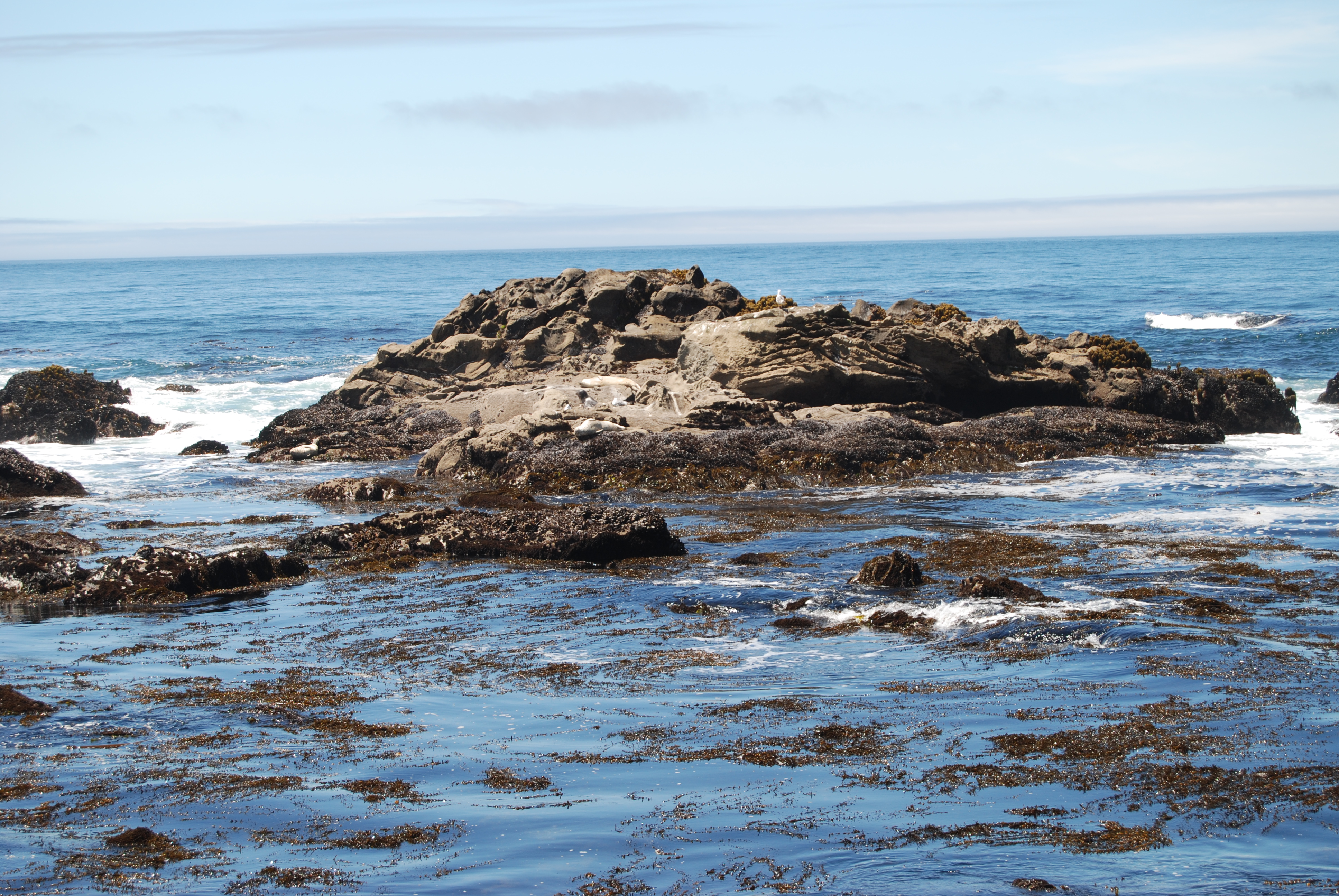
California's First Underwater Park
Gerstle Cove, where eyebolts from the old ship-loading operations still rust in the rock, became one of California's first underwater protected areas. No fishing is permitted inside the cove. Only small boats and scuba divers enter these waters, where the sandstone formations continue below the surface, creating a labyrinth of habitats for marine life. The ocean off this stretch of Sonoma County averages 52 degrees Fahrenheit - cold enough to support dense kelp forests and the slow-growing red abalone that once drew commercial divers from up and down the coast. It takes a red abalone ten years to reach seven inches in diameter. Decades of harvesting pushed the population into decline, and a long-term closure now prohibits collection entirely. Between December and April, gray whales migrate past the point on their way to breeding lagoons in Baja California, their spouts visible from the bluffs on clear days.
The Forest That Forgot How to Grow
Climb away from the coast and the landscape transforms in stages. Grassland and brush cover the marine terraces near sea level. Douglas fir takes over around a hundred feet of elevation, joined higher up by bishop pine and second-growth coast redwood. But at roughly 550 feet, something strange happens. The trees shrink. Mendocino cypress, bishop pine, and manzanita grow in a pygmy forest where mature specimens stand only a few feet tall. The cause is underfoot: a hardpan layer sits just below the soil surface, trapping water and creating extremely acidic, nutrient-starved conditions. The roots cannot penetrate the hardpan, and the chemistry stunts growth so severely that even coast redwoods - trees that elsewhere reach 350 feet - remain dwarfed. Higher still, at a thousand feet, the forest gives way to open prairie where elk once grazed. Black-tailed deer, bobcats, gray foxes, and the occasional mountain lion move through this mosaic of habitats. Pileated woodpeckers hammer in the fir groves, and Steller's jays raid unattended campsites with reliable enthusiasm.
Six Thousand Acres of Edge
Salt Point State Park covers 6,000 acres and more than six miles of some of the most rugged coastline in Northern California. Twenty miles of trails thread through the park, many of them ending at small rocky beaches bracketed by tide pools. At low tide, the pools reveal anemones, starfish, and the intricate ecosystems that form wherever rock meets cold water. Lingcod, cabezon, and rockfish draw sport fishermen between April and December. The park sits at a boundary - geologically, between two tectonic plates grinding past each other; ecologically, between marine, coastal, and forest worlds; historically, between the Kashaya Pomo homeland and the industries that reshaped it. An estimated 1,500 Kashaya people inhabited these lands before the Russian-American Company arrived on the Sonoma coast in the early nineteenth century. The salt crystals still form in the tafoni each summer, just as they did when the Kashaya scraped them free. The rocks remember the sea that made them, and the sea keeps working to take them back.
From the Air
Located at 38.57°N, 123.33°W on the Sonoma Coast, approximately 90 miles north of San Francisco. The park's six miles of jagged coastline are visible from altitude as a stretch of rocky headlands and small coves between Timber Cove to the south and Stewarts Point to the north. The tafoni-riddled sandstone formations and Gerstle Cove are best appreciated below 2,000 feet. Highway 1 traces the coastal bluffs through the park. Nearest airports: Charles M. Schulz-Sonoma County Airport (KSTS) approximately 35 nm southeast; San Francisco International (KSFO) approximately 85 nm south. Fog is frequent along this coast, especially in summer mornings.