Salt River Bay National Historical Park and Ecological Preserve
On November 14, 1493, Columbus sent a longboat ashore on the western point of a bay on St. Croix's north coast. His men were looking for fresh water and provisions. What they found was a Taino village -- and people who had no intention of welcoming them. A canoe intercepted the returning longboat, and in the skirmish that followed, one of its occupants was killed. The Spanish named the place Cabo de la Flecha: Cape of the Arrow. It was the first armed resistance by indigenous people against European invaders in the documented history of the Americas, and the people in that canoe were defending a home their ancestors had occupied since the 1300s. Today, Salt River Bay National Historical Park preserves that layered history alongside one of the Caribbean's rarest ecological treasures: a bioluminescent bay that glows in the dark.
The People Who Were Here First
Long before any European sail appeared on the horizon, the bay was the center of a thriving community. A Taino village and batey -- a ceremonial ball court -- stood here from the 1300s onward. The ball court is the only surviving example in the U.S. Virgin Islands, evidence of a sophisticated culture with its own sports, rituals, and governance. Around 1425, Carib forces conquered the settlement and enslaved many of the Taino inhabitants. When Columbus's men arrived in 1493, they encountered Taino people living under Carib control. The Spanish took some of the women and children with them -- an act of kidnapping that preceded the skirmish they would later use to justify further violence. By 1590, the indigenous population had vanished from the island, destroyed by disease, Spanish massacres, or displacement. The archaeological record at Salt River Bay spans every major period of human habitation in the Virgin Islands, reaching back through multiple South American Indian cultures to tell a story that long predates European contact.
Fort After Fort After Fort
After the indigenous people were gone, European powers fought over the bay like dogs over a bone. The English took St. Croix in 1641. The Dutch arrived the next year and built triangular earthworks they called Fort Flamand -- Flemish Fort. The French seized it in 1650 and renamed it Fort Sale, after their governor. That earthwork fortification still stands, the only known structure to survive from this early colonial period in the Virgin Islands. Each successive power left its mark, and each was eventually displaced by the next. The Danish acquired the island and held it until the United States purchased it in 1917. Congress created the national park in 1992, placing it under joint management of the National Park Service and the Virgin Islands government. The Columbus landing site had already been designated a National Historic Landmark in 1960, and in 2020, Salt River Bay was honored with its own America the Beautiful quarter -- the 53rd in the series.
Where the Water Glows
On dark nights, the water in the mangrove lagoon lights up. Dinoflagellates -- single-celled organisms called Pyrodinium bahamense -- produce bioluminescence when disturbed, turning every ripple and paddle stroke into a trail of blue-green fire. The bay is also home to bioluminescent comb-jellies and fireworms. Only seven year-round bioluminescent lagoons are known to exist in the entire Caribbean. "Any place that has a bioluminescent bay should cherish it like a natural wonder, like a treasure," says Dr. Michael Latz of the Scripps Institute of Oceanography. Red mangrove trees ring the lagoon, and researchers from the University of South Carolina, UNC Wilmington, and the University of the Virgin Islands have studied the water's nutrient composition and the distribution of dormant dinoflagellate cysts embedded in the sea floor. The National Park Service completed a comprehensive study of the bioluminescence phenomenon in 2014.
The Canyon Below
Just outside the bay, the seafloor drops away. Salt River Canyon is a prehistoric feature -- an ancient river and waterfall that carved two sheer walls facing each other across a quarter mile of blue water. The canyon plunges nearly 500 feet deep, well beyond recreational diving limits of 130 feet, though most boat moorings sit at a comparatively modest 25 to 45 feet. The underwater visibility here ranks among the top five in the Caribbean according to Sport Diver Magazine. Humpback whales nurse their calves in these waters during February and March. Nurse sharks and reef sharks patrol year-round. Dolphins pass through in pods. Above the waterline, the park encompasses some of the largest remaining mangrove forests in the Virgin Islands, along with coral reefs and the submarine canyon -- an interlocking ecosystem where saltwater and freshwater, land and sea, ancient geology and living biology exist in a balance that has sustained this place for millennia.
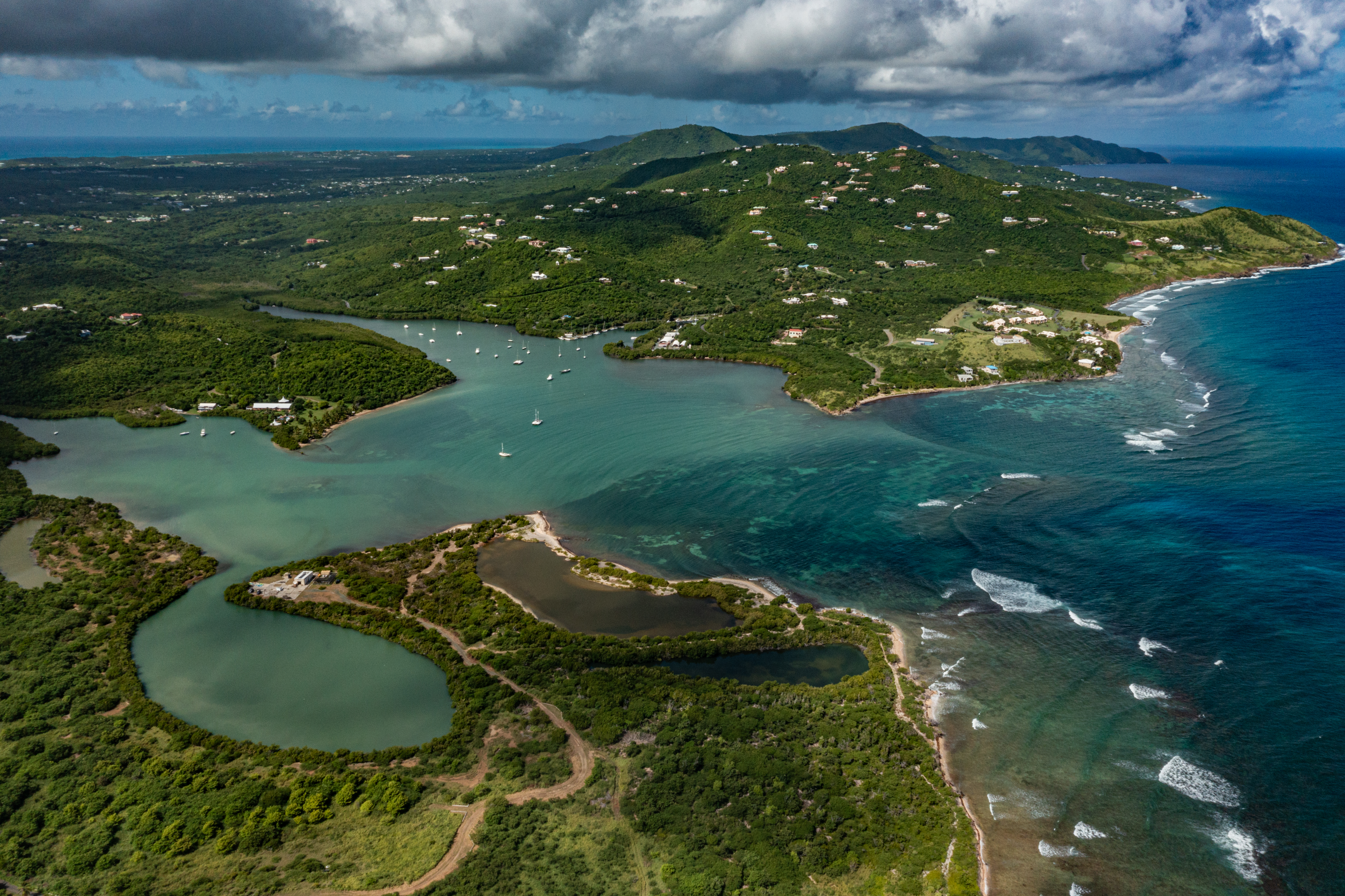
From the Air
Salt River Bay is on the north-central coast of St. Croix (17.779N, 64.759W). The bay is clearly visible from 2,000-4,000 feet AGL as a large inlet with mangrove-lined shores. The point on the western side of the bay is the Columbus landing site, marked by the earthworks of Fort Sale. Salt River Canyon extends offshore to the north. Nearest airport: Henry E. Rohlsen Airport (TISX/STX) approximately 9 miles south. Christiansted and its harbor are visible about 2 miles to the east. The mangrove lagoon where bioluminescence occurs is at the inner reaches of the bay.