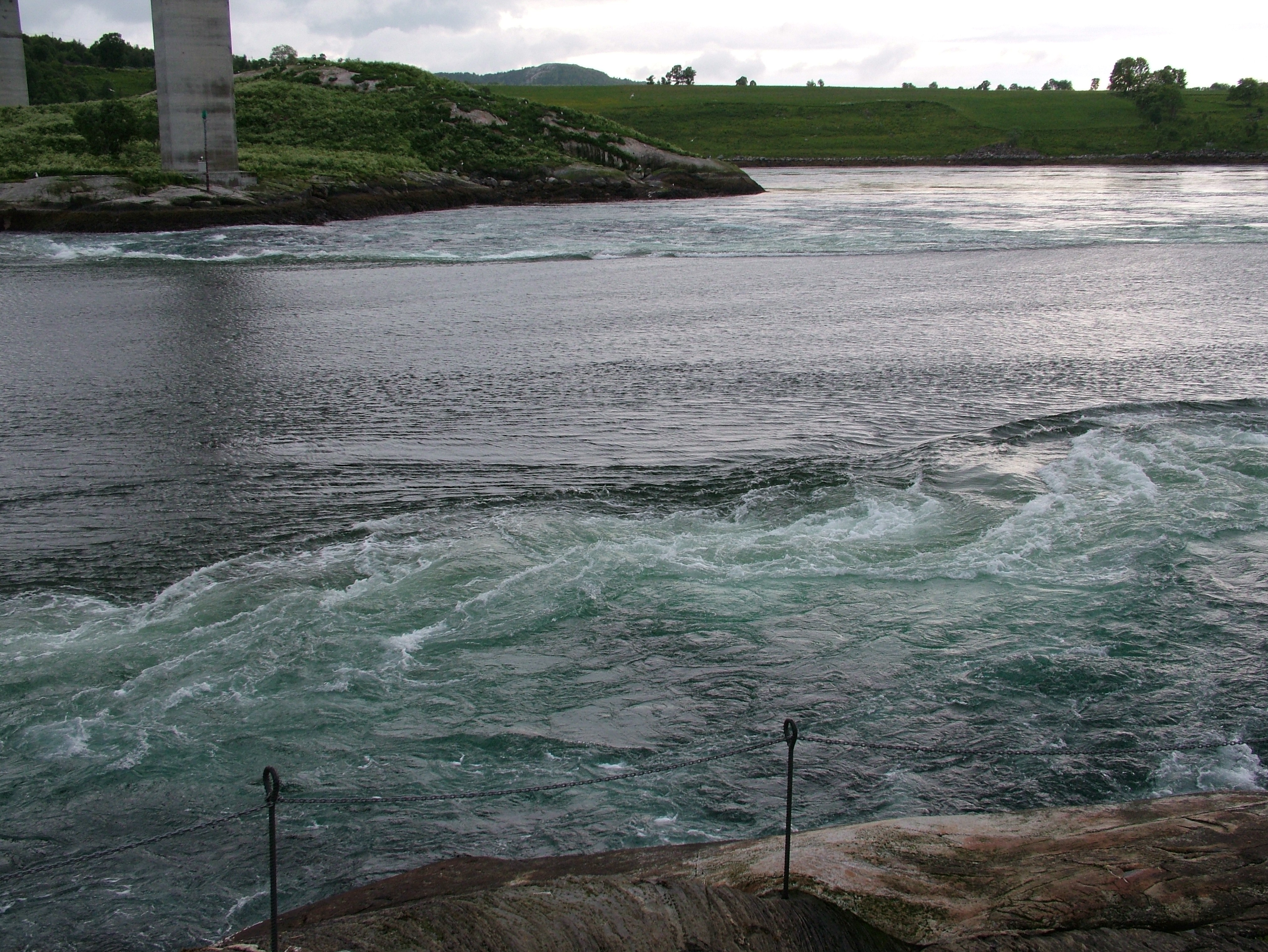
Saltstraumen
Every six hours, the sea decides to rearrange itself. Four hundred million cubic meters of seawater force through a channel barely 150 meters wide and 3 kilometers long, connecting the outer Saltfjorden to the vast Skjerstad Fjord. The result is Saltstraumen, located about 10 kilometers southeast of Bodø in Nordland county, Norway—one of the strongest tidal currents on Earth. Whirlpools up to 10 meters across and 5 meters deep spin into existence as the current peaks, and the water can reach speeds of over 8 knots on the outflow. This is not a gentle phenomenon. It is the ocean demonstrating what happens when enormous volumes of water have no room.
The Engine Beneath the Surface
The mechanics are deceptively simple. Twice a day, the tide attempts to fill Skjerstad Fjord through the only gap available—the narrow strait between the islands of Straumøya and Knaplundsøya. The height difference between the open sea and the fjord inside can reach a full meter, and that pressure differential drives the current with remarkable force. The greatest southbound (inflowing) current occurs roughly one and a quarter hours before high tide at Bodø, reaching about 7 knots. But the outflow is even stronger: about four and a half hours after Bodø high tide, the northbound current exceeds 8 knots as the fjord drains back toward the sea. Strong winds and snowmelt from surrounding mountains can alter the pattern, making the strait occasionally unpredictable. Between tidal surges, there are brief windows when the water calms enough for boats to navigate through—windows that local fishermen have learned to read for generations.
A Young Strait with Ancient Visitors
Saltstraumen itself is only two to three thousand years old. Before that, the landscape looked entirely different—post-glacial rebound was still reshaping the coastline, and the channel that would become the strait had not yet formed. But human presence here is far older than the current. The remains of a 10,000-year-old hunter settlement discovered nearby represent the oldest known traces of human habitation in the Bodø area and one of the oldest archaeological finds in all of Norway. These Stone Age hunters camped at the edge of retreating ice, drawn to these waters by the same force that draws visitors today: the extraordinary abundance of marine life that turbulent currents produce. Where water churns, nutrients rise, and where nutrients rise, fish gather. Ten millennia later, that fundamental equation has not changed.
Where the Fish Run Thick
Anglers travel from across Scandinavia and beyond to fish Saltstraumen, and the strait delivers. Saithe, cod, wolffish, rose fish, and halibut all thrive in these nutrient-rich waters, drawn by the constant upwelling that the tidal surge creates. Coalfish is the local specialty—the largest documented coalfish ever caught on a rod, weighing 22.7 kilograms, came out of Saltstraumen. The fishing is not casual. Timing matters enormously, because the current dictates when and where fish congregate. Cast at the wrong moment and you are fighting the water itself; cast at the right moment and the sea practically hands you dinner. Even the birdlife here reflects the power of the current. Eiders are the only birds capable of diving for mussels in the full force of the stream—every other species waits for calmer water.
The Name and the Bridge
The name Saltstraumen combines two elements: Salten, the surrounding district, and straum, the Old Norse word for stream or water flow. It is a name that describes exactly what it is—no embellishment needed. The Saltstraumen Bridge, carrying Norwegian County Road 17, spans the strait and offers a vantage point that has made this natural spectacle accessible to anyone willing to stop and look down. From the bridge, the vortices are visible as dark spiraling discs against the lighter water, spinning and dissolving and reforming in a continuous display that shifts with every tidal cycle. BBC's nature series "A Perfect Planet" captured unique underwater footage here, revealing a world beneath the surface where kelp forests bend flat in the current and marine life clings to rock faces against forces that would sweep anything else away. The strait has been depicted in Norwegian schoolbooks since at least 1837, appearing in illustrations that show the same churning water visitors see today.
From the Air
Saltstraumen lies at 67.23°N, 14.61°E, about 10 km southeast of Bodø. From the air, the strait is visible as a narrow channel between the islands of Straumøya and Knaplundsøya, connecting the outer Saltfjorden to Skjerstad Fjord. The Saltstraumen Bridge crossing the strait is a useful visual reference. The Børvasstindene mountain range rises in the background. Best viewed at lower altitudes (2,000–5,000 ft) when tidal currents are active—whirlpool patterns may be visible in clear conditions. Nearest airport: Bodø Airport (ENBO), approximately 10 km northwest.