San Francisco Bay Discovery Site
"From the summit of a peak we beheld the great estuary or arm of the sea." Franciscan missionary Juan Crespi wrote those words in his diary on November 4, 1769, and the bay he described would become one of the most consequential geographic features in American history. The Portola expedition had not been looking for it. They were searching for the Port of Monterey, described by Sebastian Vizcaino in 1602, and when they failed to recognize it, they kept walking north. What they found instead -- by accident, exhaustion, and stubbornness -- was San Francisco Bay.
The Wrong Turn That Changed Everything
The expedition had traveled north by land from San Diego, a grueling march through unfamiliar territory. When they reached Monterey, the landscape did not match Vizcaino's 167-year-old description closely enough for certainty, so the commander Gaspar de Portola decided to press on. The party reached San Pedro Creek on October 31, 1769, and camped for four nights. Scouts led by Jose Francisco Ortega climbed Sweeney Ridge while the main party rested below. On November 1, the scouts crested the ridge and looked east. The immense bay spread before them, far too large to ford or skirt. When they returned on November 3, they led the entire party up to see for themselves. The Golden Gate blocked further progress to the north. The expedition turned southeast and descended toward the bay.
A Ridge Between Two Worlds
Sweeney Ridge rises to 1,200 feet in northern San Mateo County, its summit covered with coastal scrub and grassland. To the west, the Pacific Ocean stretches to the horizon. To the east, San Francisco Bay opens wide. The ridge sits on the boundary between these two worlds, and in 1769 it served as the threshold across which European understanding of California's geography permanently shifted. The discovery of the bay would lead, within seven years, to the founding of the Presidio of San Francisco and Mission San Francisco de Asis. Within a century, the bay would anchor one of the world's great cities. The scouts who climbed the ridge could not have known any of this. They were tired, lost, and looking for a port that was behind them.
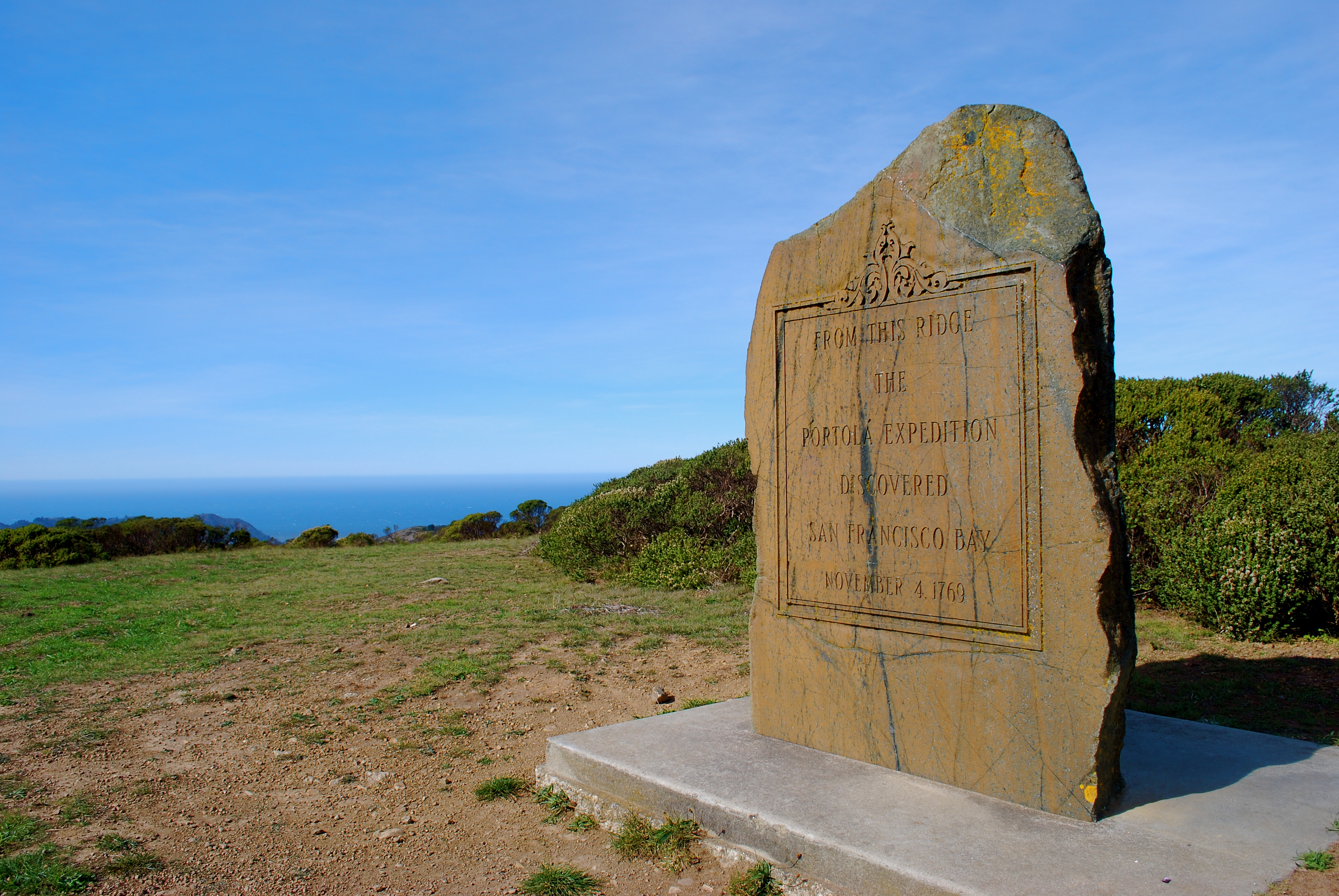
Monument and Memory
The San Francisco Bay Discovery Site is now part of the Golden Gate National Recreation Area. A marker on the ridge commemorates the moment, and the site holds dual designation as both a California Historical Landmark and a National Historic Landmark. Hikers reach it today via trails from Pacifica's Shelldance Nursery, from Fassler Avenue, or from Skyline College in San Bruno. The walk is moderate, climbing through coyote bush and lupine to the ridgetop, where on clear days the same panorama that astonished Ortega's scouts spreads out in every direction. It is one of the few places in California where you can stand at the exact spot where a pivotal moment in history occurred and see essentially the same landscape the participants saw, minus a few million people.
From the Air
Located at 37.60°N, 122.46°W on Sweeney Ridge between San Bruno and Pacifica. The ridge rises to 1,200 ft and is part of the Golden Gate National Recreation Area. San Francisco International (KSFO) is approximately 5 nm east. The discovery site marker is at the ridgetop and not visible from altitude, but the ridge itself is a prominent terrain feature.