San Juan Mountains
The name on the map says mountains, but the San Juans are really the ruins of volcanoes. Dozens of calderas, some stretching miles across, collapsed here millions of years ago, and the peaks that remain are what the eruptions left behind. One of those calderas, La Garita, produced what geologists consider one of the most powerful volcanic eruptions in Earth's history, obliterating the volcanoes that once stood in its place and scattering ash across much of North America. Today those same slopes glitter with wildflowers in summer and avalanche debris in winter, and the towns wedged into the valleys below still carry the names and scars of the silver and gold rush that dragged thousands of prospectors into this remote corner of Colorado.
Fortunes Carved from Stone
The San Juan Mountains sit squarely on the Colorado Mineral Belt, and for decades in the late 1800s, that meant everything. Mining camps sprang up at Creede, Lake City, Silverton, Ouray, and Telluride, each chasing veins of gold and silver through rock of volcanic origin. The Camp Bird and Smuggler Union mines, both tucked between Telluride and Ouray, became legendary producers. The Sunnyside Mine near Silverton held on until the late twentieth century, and the Idarado Mine on Red Mountain Pass did not close until the 1970s. But mining was never just about treasure. In 1903, operators across San Miguel, Ouray, and San Juan counties formed the San Juan District Mining Association specifically to block the eight-hour workday that 72 percent of Colorado voters had approved by referendum. The resulting standoff with the Western Federation of Miners provoked a bitter strike that echoed through the valleys.
Ghost Towns and Iron Horses
When the silver ran thin, the towns did not all vanish. Some became ghost towns, their abandoned houses slowly folding into the hillsides at places like Eureka and Gladstone. Others reinvented themselves. The narrow gauge railway between Durango and Silverton, once a lifeline for ore shipments, now carries tourists through the Animas River gorge in restored coaches. Off-roaders tackle the old mining trails that once connected camps across high passes, including the notorious Black Bear Road, a switchback descent so steep it makes experienced drivers grip their steering wheels. Silverton found a second calling as the home of the Hardrock 100 Endurance Run, one of the most punishing ultramarathons on Earth, where runners traverse 100 miles of terrain above 10,000 feet, crossing thirteen mountain passes along the way.
The Roof of the Colorado River
Water leaving the San Juans flows to two oceans. The Rio Grande drains the eastern slopes, eventually reaching the Gulf of Mexico. The western side feeds the San Juan, Dolores, and Gunnison rivers, all tributaries of the Colorado River. The highest summit in the range, Uncompahgre Peak, also claims the distinction of being the highest point in the entire Colorado River drainage basin. The Weminuche Wilderness, Colorado's largest wilderness area, sprawls across the southern San Juans, and 152 miles of the Continental Divide Trail wind along the range's spine. The San Juan and Uncompahgre National Forests blanket much of the terrain, preserving a landscape where elk still outnumber people and alpine tundra begins above treeline at roughly 11,500 feet.
High Altitude Living
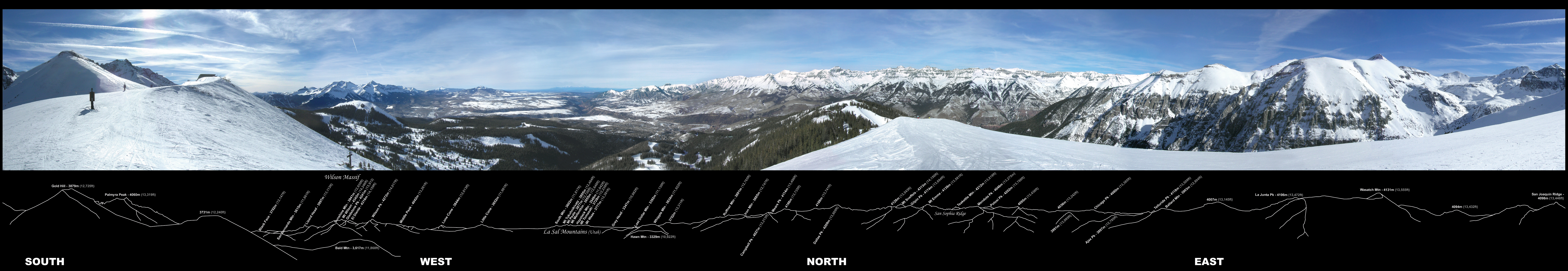
The San Juans are defined by their sheer vertical reach. Telluride Airport sits at 9,070 feet, making it the highest commercial airport in the United States with regularly scheduled service. Telluride itself has become a major ski resort, while Purgatory Resort serves skiers 26 miles north of Durango, and Wolf Creek ski area perches atop Wolf Creek Pass, famous for the deepest snowpack in Colorado. Silverton Mountain, a no-frills ski area with no groomed runs, draws expert skiers seeking untracked powder. In summer, mountain bikers and trail runners converge on the same terrain. The old mining camps have become seasonal communities, their Victorian-era buildings now housing galleries and restaurants. Yet the mountains remain uncompromising. Avalanches close passes every winter, afternoon thunderstorms build with startling speed above treeline, and the thin air at 13,000 feet reminds every visitor that these peaks set their own terms.
From the Air
The San Juan Mountains are centered near 38.07N, 107.45W in southwestern Colorado. Peaks exceed 14,000 feet, so maintain altitudes well above that for safe overflights. Telluride Regional Airport (KTEX) at 9,070 feet is the highest commercial airport in the US. Durango-La Plata County Airport (KDRO) at 6,685 feet offers an alternate approach from the south. Mountain wave turbulence and rapid weather changes are common. The narrow gauge railway route along the Animas River between Durango and Silverton is visible from altitude, as are the distinctive red slopes of Red Mountain Pass and the remnants of mining operations scattered across the range.