Sanaa Governorate
The capital of Yemen sits inside a province that does not actually contain the capital. Sanaa Governorate wraps around the city of Sanaa - which was carved out as its own administrative unit called Amanat Al-Asemah - and extends outward across 16 districts in a rough ring of highlands, wadis, and escarpments. In 2004 the governorate counted 2.9 million people. Somewhere in the Bani Matar district rises Jabal An-Nabi Shu'ayb, also called Jabal Hadhur, the highest mountain in Yemen and the highest in the entire Arabian Peninsula.
The Mountain That Outranks All Others
Jabal An-Nabi Shu'ayb reaches 3,666 meters - higher than any peak in Saudi Arabia, Oman, or the other Arabian nations. Its summit belongs to the Haraz subrange of the Sarawat mountains. The name attaches to the prophet Shu'ayb, identified in Islamic tradition with the Jethro of the Hebrew Bible, Moses's father-in-law. Villagers on its slopes have told pilgrims about this association for centuries. The mountain's southern face drops dramatically toward the Red Sea coast. Its northern slope rolls into the central highlands where wheat, sorghum, and qat are cultivated on terraces that climb in tight rings up hillsides and have been maintained by essentially the same methods for millennia.
Rings of Districts
The governorate is divided into 16 districts arranged roughly by cardinal direction. Northern districts - Nihm, Arhab - reach toward the desert border with Al Jawf. Western districts include Hamdan, Bani Matar, Al Haymah Ad Dakhiliyah, Al Haymah Al Kharijiyah, Manakhah, and Sa'fan - the cool, terraced, mountain heartland of classical Yemeni agriculture. Eastern districts - Bani Hushaysh, Sanhan, Bilad Ar Rus, Attyal, Jihanah, Al Husn, Khwlan, and Bani Dhabyan - lean toward the gravel plains and basaltic outcrops that eventually fall away toward Marib. Each district is further subdivided into sub-districts and villages, and each carries its own dialect, its own feuds, its own tribal compacts that predate and survive every central government that has tried to rule them.
The Villages
The populated places list for Sanaa Governorate runs to hundreds of names - Bayt Baws, Bayt Naamah, Bayt Kahin, Bayt Shu'ayb, Hababah, Haddah, Kushar, Manakhah, Ghayman, Madhbah. Many are built on basalt plugs or defensible crags, small fortified communities of stone tower houses that date in some cases to pre-Islamic times. Others cluster in wadis where underground water makes cultivation possible. The architecture is continuous across the governorate - multi-story houses in earth and basalt, upper floors decorated with plasterwork, the distinctive qamariya windows above each room catching the high light of the Yemeni sun. These are the villages that feed and surround the capital. The rural economy here - subsistence grain, livestock, and qat - sustains a population that has largely resisted urbanization despite the pressures of decades of conflict.
A Province Under Siege
Since the 2014 Houthi takeover and the 2015 start of the Saudi-led intervention, Sanaa Governorate has been under de facto Houthi control. Airstrikes have damaged infrastructure throughout. The water system, already stressed - Sanaa draws from the Tawilah aquifer at rates that exceed natural recharge by several hundred percent - has deteriorated further. Fuel shortages have pushed farmers back toward hand labor on terraces their grandfathers cultivated the same way. Humanitarian aid, when it arrives, passes through checkpoints in villages whose names outsiders cannot pronounce. Cholera returned in 2017 in what the World Health Organization called the worst outbreak in modern history. The rural population has absorbed all of this with the stoicism that mountain peoples tend to develop over long centuries, and the governorate continues to function - in the ways that matter locally - as it has for generations.
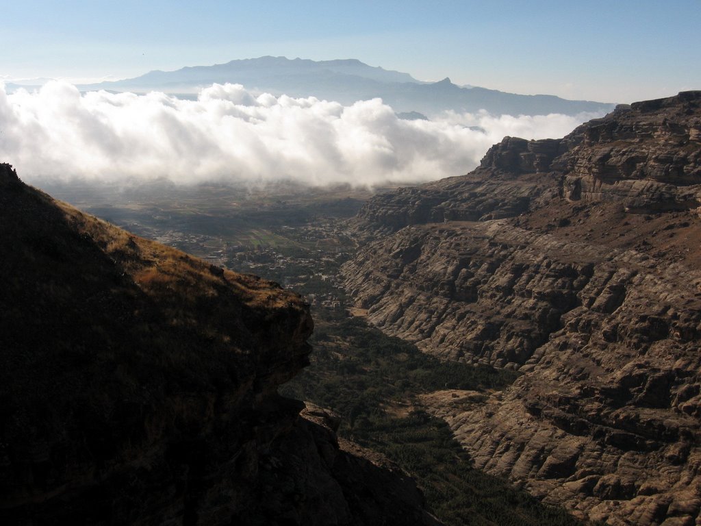
Aerial Views
From altitude the governorate resolves into terraced slopes, cultivated wadis, and the massive volcanic bulk of Jabal An-Nabi Shu'ayb rising above the central plateau. The provincial ring runs around Sanaa city like a hand cupping the capital. Agricultural patterns show clearly - the green of khat plantations in the western highlands, the tan of dryland grain in the east, the fractured basalt tablelands to the north. Villages appear as tight stone clusters on hilltops. Roads snake through canyons. In clear winter air, visibility from 10,000 meters can extend to the Red Sea coast, the mountain casting a visible rainshadow to the east.
From the Air
Located at 15.35°N, 44.20°E centered on the Yemeni central highlands. Active conflict zone - no general aviation access. Sanaa International Airport (OYSN/SAH) lies within the governorate. Recommended viewing altitude FL300+ for overview. Jabal An-Nabi Shu'ayb (3,666m) in the Bani Matar district is the tallest peak in the Arabian Peninsula and is clearly visible from altitude. Haze common in summer, clearer visibility in winter months.