.jpg)
Sangkae River
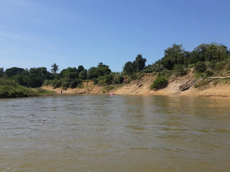
Stand a three-metre pole upright in the Sangkae in March and most of it stays dry. Come back in September and you would need one more than twice as long. Measurements taken by Battambang's Department of Water Resources put the river's average depth at 2.35 metres in the dry season and 6.79 metres at the height of the rains - a river that effectively becomes a different river twice a year, and a province that has organised its farming, fishing and building around knowing exactly when the change comes. The Sangkae runs roughly 250 kilometres from the Cardamom foothills near the Thai border down through six districts and twenty-seven communes of Battambang province, and it does more work per kilometre than almost any waterway in Cambodia.
The City the River Made
Battambang exists because of this water. The settlement began as a fishing village on the Sangkae in the eleventh century, and for most of its history the river, not any road, was the way in and out. Siam annexed the region in 1795 and ran it as the capital of Inner Cambodia; by 1880 the town held around 2,500 people and the Sangkae was its main link to Phnom Penh and Saigon. When the province was ceded to France in 1907 the colonial administration laid a grid of streets, cut open canals, and in 1917 threw two bridges across to tie the banks together - the layout that survives as Battambang's heritage conservation area today. A railway to Phnom Penh followed in 1926. The river has since been overtaken as a transport artery, but the city it produced is now Cambodia's third largest, and was named a UNESCO City of Gastronomy in 2023.
Two Branches and a Great Lake
Five kilometres south of central Battambang, at Khwaeng pagoda, the river divides. The smaller fork swings east and passes through Sangkae village, six kilometres from the city centre, lending its name to Sangkae District. The main branch runs on into the Tonlé Sap floodplain about five kilometres below Preak Trob village, where it takes in the Serei Sophorn river at Prey Chas; the two branches find each other again at Thvang. From there the Sangkae stops behaving like a river at all. It spreads into the seasonally flooded forest of the western Tonlé Sap Biosphere Reserve and arrives at the lake near Prek Toal - a 42,000-hectare bird sanctuary declared a Ramsar wetland on 2 October 2015, and in the dry months one of the great waterbird gatherings of Southeast Asia. Whatever the Sangkae carries down from the mountains ends up here.
Arrow Traps and a Closed Season
Along the banks, fishing is done with nets and with arrow-shaped traps set into the current, funnelling fish into a chamber they cannot reverse out of - a design that costs almost nothing and works without an engine. The river also gives villages their route to the lake's far richer fisheries. Upstream, the Sangkae system supplies drinking water and irrigation to roughly a million people before it ever reaches the Tonlé Sap. Because the whole system depends on fish that spawn in the flood, industrial fishing is closed during the wet-season peak from June to October. Human works have added their own complications. The Seksak hydropower plant sits on the river near Traeng, about 45 kilometres southwest of Battambang, and its dam has raised an artificial lake with a tourism resort on the shore - though by 2015 local people were arguing that the rising water was undermining the very attraction it created.
What Comes Downstream
Industry has settled along the lower river, and the river has been sending back reports. In 2021 the provincial authorities opened an investigation into suspected chemical pollution after dead fish were found downstream. Two years later one company was fined 500,000 US dollars for dumping liquid waste into the Sangkae, and on 4 August 2023 the Provincial Administration announced a separate chemical leak from another plant. For a waterway that feeds drinking supplies, irrigated rice, a subsistence fishery and a Ramsar bird colony in a single 250-kilometre run, these are not local incidents. There is still a ferry that leaves Battambang and takes five or six hours to reach Siem Reap by way of the Sangkae and the open lake. It remains the best way to understand the river - not as a line on a map, but as the thing all of this is balanced on.
From the Air
The Sangkae rises in the Cardamom foothills near 12.32N, 102.87E and runs northeast for about 250 km to the Tonlé Sap, entering the lake near Prek Toal at roughly 13.22N, 103.70E. From the air it is one of the clearest navigational features in northwestern Cambodia: a dark meandering line through paddy, splitting into two visible branches south of Battambang and dissolving into flooded forest at the lake margin. Seasonal contrast is dramatic - the floodplain can double in width between March and October. Recommended viewing altitude is 3,000-6,000 ft to follow the channel, or 10,000 ft for the full run to the Tonlé Sap. Battambang Airport (VDBG) sits 3 km from the city centre on the river; Siem Reap-Angkor International (VDSA) lies across the lake to the northeast, and Techo International at Phnom Penh (VDTI) about 240 km southeast. Haze is common in the March-April burning season.
Nearby Stories
- Central Cardamom Mountains National Park 25 km away
- Battle of Pailin 33 km away
- Khlong Yai 40 km away
- Pursat 63 km away
- Tonlé Sap 81 km away
- U-Tapao: The Airfield Built on a Shipyard 141 km away
- The Sanctuary of Truth: One Man's Unfinished Cathedral 167 km away
- Lampi Island Marine National Park 465 km away