Sangre de Cristo Mountains
According to legend, the words "sangre de Cristo" were the last uttered by a priest killed in the mountains, and whether or not the story is true, anyone who has watched sunrise ignite these snow-covered ridges in crimson and amber understands why the name endured. The Sangre de Cristo Mountains are the southernmost subrange of the Rocky Mountains, running from Poncha Pass in south-central Colorado southeast and south for roughly 220 miles to Glorieta Pass near Santa Fe, New Mexico. Before the Spanish name took hold in the early 19th century, these peaks were called La Sierra Nevada, La Sierra Madre, or simply The Snowies by English speakers. The mountains they described are anything but simple.
Fourteeners and Forbidden Summits
The Colorado portion of the Sangre de Cristos bristles with peaks above 14,000 feet. The Crestones, a cluster of four fourteeners rising above the tiny community of Crestone, rank among the most technically demanding summits in the state. Blanca Peak, the range's highest point, anchors the Sierra Blanca massif at the northern end. Further south, in the Culebra Range, sits Culebra Peak, the only fourteener in Colorado on private land. Climbers wishing to stand on its summit must pay a fee of $150 per person, and the number allowed each year is strictly limited. Culebra is also the most southerly fourteener in the U.S. Rockies, marking the point where the truly towering heights of the range begin their descent toward New Mexico.
The Wall Between Two Worlds
The Sangre de Cristos serve as a dramatic natural barrier. The northern section, the Sangre de Cristo Range proper, runs 75 miles along the eastern edge of the Rio Grande rift, forming a high ridge that separates the arid San Luis Valley on the west from the Arkansas River watershed on the east. The Spanish Peaks, a pair of mountains in Huerfano County, were designated a National Natural Landmark in 1976 as one of the finest examples of igneous dikes anywhere in the world. Visible from as far away as Colorado Springs to the north and Raton, New Mexico to the south, these twin peaks served as critical landmarks for 19th century travelers on the mountain branch of the Santa Fe Trail.
Land Grants and Lasting Disputes
The western slope of the Culebra Range and the San Luis Valley lie within the Sangre de Cristo Land Grant, dating back to the 1840s. The town of San Luis, Colorado, one of the oldest communities in the state, sits in an arid landscape that receives minimal annual precipitation. The surrounding area, watered by Culebra Creek, has supported agriculture for generations. But the land grant's legacy is tangled. Since the 1860s, descendants of Hispanic settlers and Anglo ranchers have clashed over ownership and access rights in disputes that continue to shape the pattern of land ownership across the grant.
Sacred Ground at Taos
South of the Colorado border, the Taos Mountains form the range's most culturally significant section. Wheeler Peak, the highest point in New Mexico, anchors the Wheeler Peak Wilderness. Pueblo Peak rises dramatically above Taos Pueblo, and much of the central Taos Mountains lies on Pueblo land, sacred and largely closed to outsiders. Taos Ski Valley sits just west of Wheeler Peak, offering some of the steepest lift-served terrain in the southern Rockies. From the town of Taos below, the entire massif is simply called Taos Mountain, a singular name for a range that dominates the horizon in every direction.
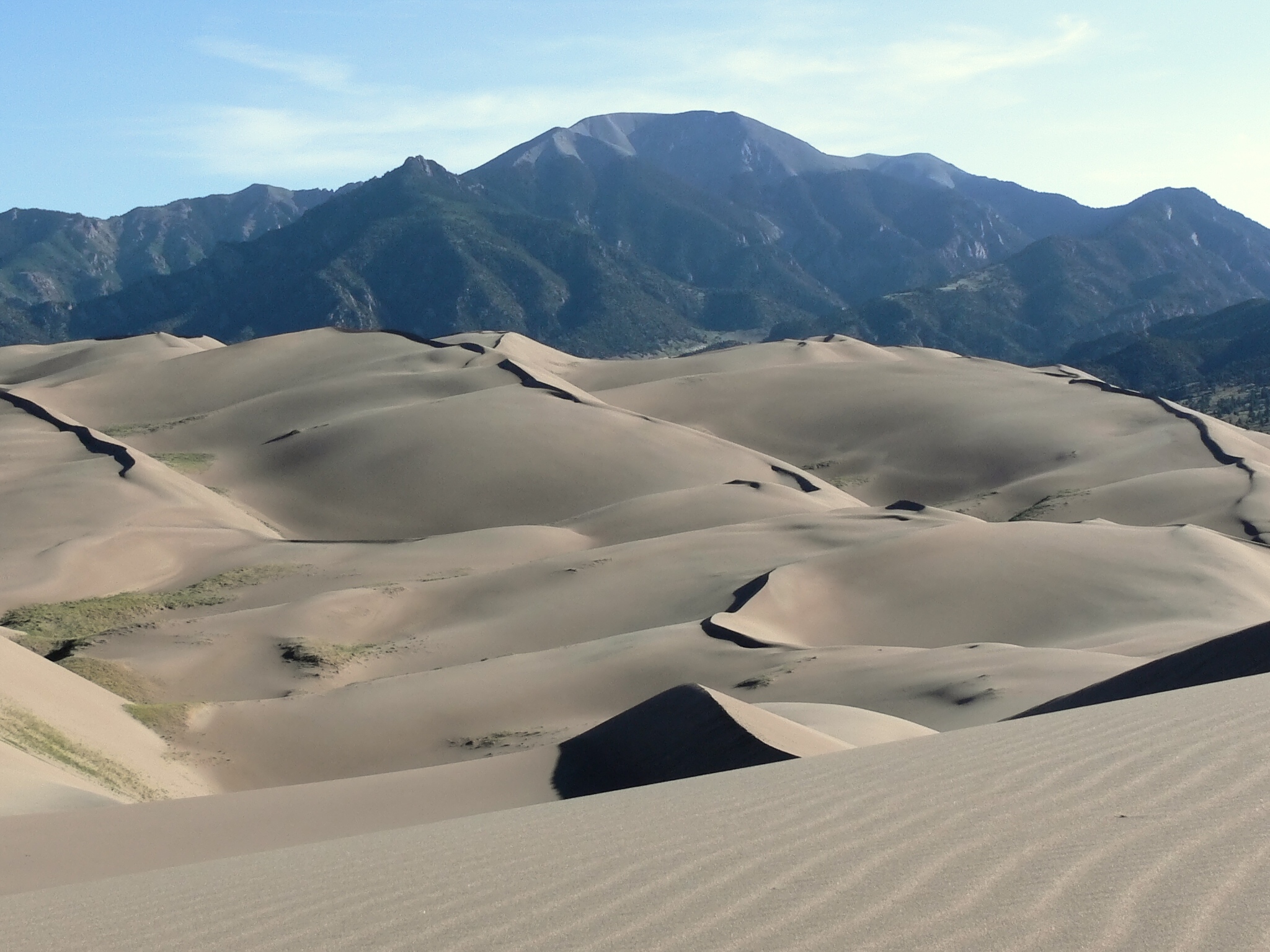
Wild Country, Public Land
Much of the Sangre de Cristos is managed by the U.S. Forest Service across four national forests: the Rio Grande and San Isabel in Colorado, the Carson and Santa Fe in New Mexico. Two major wilderness areas protect the range's wildest country: the Sangre de Cristo Wilderness in Colorado and the Pecos Wilderness in New Mexico, along with smaller areas like the Latir Peak Wilderness. On the range's southwest flank, the Great Sand Dunes National Park and Preserve occupies a surreal landscape where North America's tallest sand dunes pile against the base of 13,000-foot peaks. Hikers, climbers, mountain bikers, and skiers all find their terrain here, drawn by a range that offers everything from desert dunes to alpine ice.
From the Air
The Sangre de Cristo Mountains extend roughly 220 miles from Poncha Pass (38.5N) to Glorieta Pass near Santa Fe (35.6N), with the coordinates 37.58N, 105.49W marking the central Colorado portion near the Sierra Blanca massif. Blanca Peak rises to 14,345 feet and is visible from considerable distances. The Great Sand Dunes are unmistakable on the southwest flank. The range forms a continuous high wall separating the San Luis Valley from the plains to the east. Nearest airports: San Luis Valley Regional/Bergman Field (KALS) in Alamosa approximately 25nm west, Pueblo Memorial (KPUB) approximately 60nm northeast. Expect strong mountain wave turbulence along the ridgeline, particularly with westerly flow. Minimum safe altitude should account for peaks above 14,000 feet in the northern section.