Sani Pass
The road, if you can call it that, crosses no fewer than switchbacks carved into raw cliff face, climbing from the green foothills of KwaZulu-Natal to the windswept highlands of Lesotho. Sani Pass is the kind of road that makes passengers grip their armrests and stare at the drop. It was first crossed by vehicle in 1953, and more than seventy years later it still demands four-wheel drive, low range, and nerve. At the top, where South Africa falls away behind you and Lesotho's treeless plateau stretches to the horizon, a small lodge claims to serve drinks at Africa's highest pub. The altitude is 2,874 meters. The beer is cold. The view is worth every white-knuckled kilometer.
The Road That Refused to Be Tamed
Sani Pass connects the town of Underberg in KwaZulu-Natal with the highlands of Lesotho, climbing the Drakensberg escarpment through a series of hairpin turns that gain over 1,300 meters in elevation. The route follows the path of old bridle trails used by traders and Basotho herdsmen long before anyone attempted it in a vehicle. That first motorized crossing in 1953 proved the road could be driven, but decades of use have not domesticated it. Rain loosens the gravel surface, fog erases the edge of the road, and in winter, ice turns the switchbacks into something best left to the imagination. The South African side requires a 4x4, and several companies in Underberg operate guided tours for those who prefer someone else to handle the steering. You will need your passport, and for children, birth certificates. This is an international border crossing, even if the customs post at the top feels like it belongs in another century.
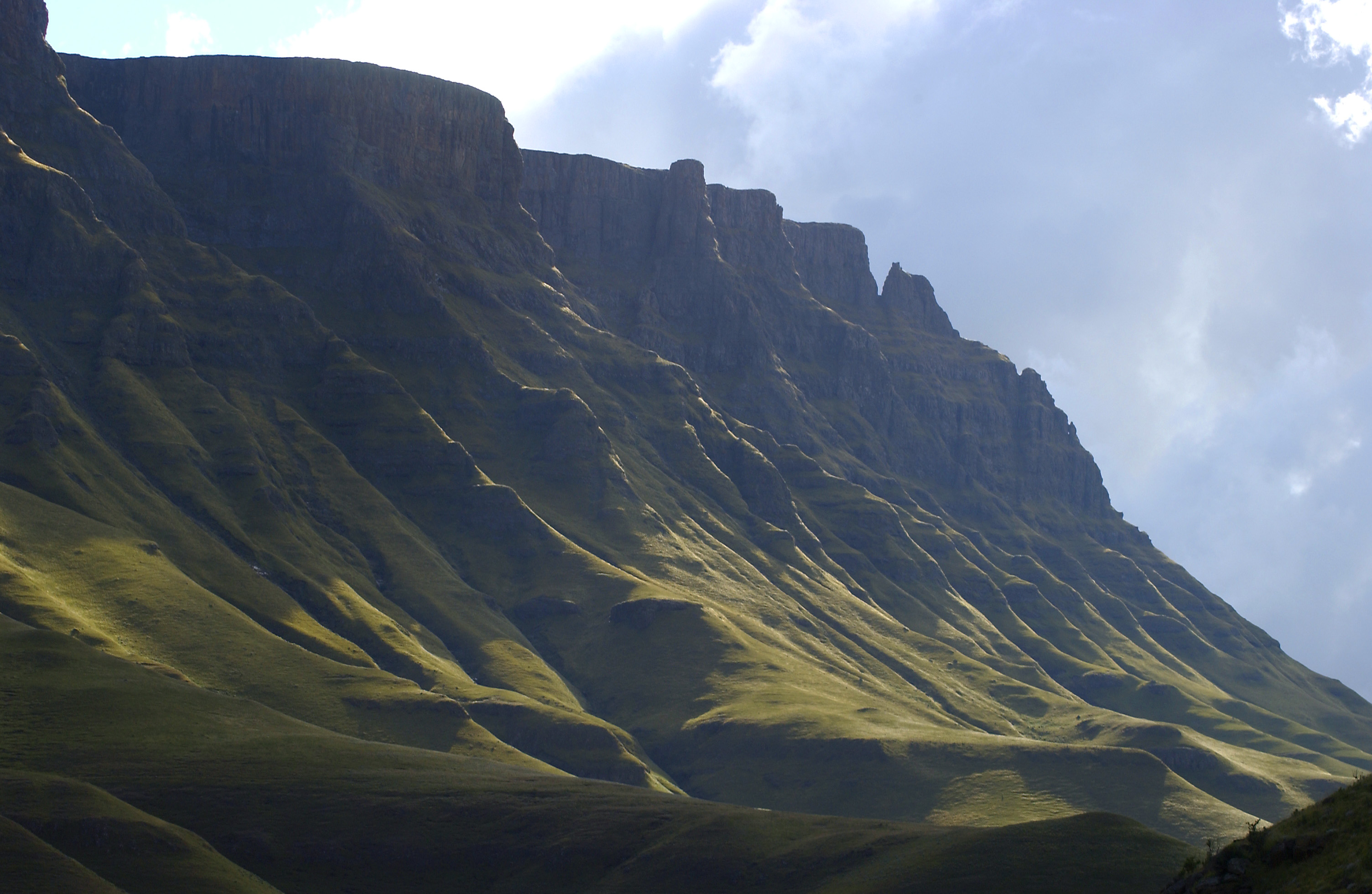
Between Two Worlds
The transformation as you climb is dramatic. At the base, the landscape is green and subtropical, with sugarcane fields and mist-belt forests giving way to montane grassland. By the time you reach the top, the vegetation has thinned to hardy tussock grasses and the air has a bite that surprises visitors who left the coast in shorts. Lesotho's highlands are a different country in every sense. The Basotho people who live here wrap themselves in traditional blankets against the cold and ride sturdy mountain ponies across terrain where vehicles cannot follow. From Sani Mountain Lodge at the summit, the Drakensberg escarpment drops away to the east in a wall of basalt cliffs and buttresses that stretches north and south as far as the eye can reach. On clear days, the haze lifts enough to reveal the patchwork farmland of KwaZulu-Natal far below, a green world that feels impossibly distant from this windswept plateau.
Walking the Rooftop
The hiking from the top of Sani Pass is superb, if you can handle the altitude. To the north lies Thabana Ntlenyana, the highest peak in southern Africa at 3,482 meters. The terrain is not technically difficult, but the thin air at this elevation turns a straightforward walk into a lung-burning affair. The round trip from Sani Mountain Lodge takes a minimum of eight hours, and hikers should set off early enough to return before dark, when temperatures plummet and navigation becomes treacherous. Closer options lie to the south. A pyramid-shaped peak is visible from the lodge, reachable in about 75 minutes. Beyond it, three more summits beckon, and an ambitious walker can bag all four and return within six hours. The landscape up here has a stark, lunar quality, all rock and grass and enormous sky, interrupted only by the occasional Basotho shepherd leading a flock across the plateau.
Cold Beer at the Edge of the Sky
Sani Mountain Lodge is the social heart of the pass. It serves lunch to day-trippers and provides accommodation ranging from warm rondavels with fireplaces and en-suite showers to backpacker dormitories where hot water and electricity arrive only in the evening. Horse riding and mountain biking are available, and in a quirk that delights visitors, horses are cheaper to rent than bicycles. The lodge's pub, perched at 2,874 meters, has long claimed the title of Africa's highest bar, though the ski resort at Afriski, further into Lesotho at 3,222 meters, disputes the honor. The debate hardly matters when you are sitting with a beer, watching the afternoon light turn the Drakensberg escarpment gold, and listening to the wind carry sounds from a valley that is, by the altimeter, nearly a vertical mile below.
From the Air
Coordinates: 29.59°S, 29.29°E, on the Drakensberg escarpment at the border between KwaZulu-Natal, South Africa, and Lesotho. The pass climbs from roughly 1,500 m to 2,874 m at Sani Top. From the air, the switchbacks are visible as a pale scar zigzagging up the dark basalt escarpment. The Drakensberg wall runs north-south and is one of the most visually dramatic features in southern Africa from altitude. Nearest airports: Pietermaritzburg (FAPM) approximately 100 nm northeast; Moshoeshoe I International (FXMM) at Maseru approximately 100 nm west. Terrain rises sharply; maintain safe altitude above the 3,000 m ridgeline. Turbulence and orographic cloud common along the escarpment, especially in afternoon.