Santa Ana Volcano
The Pipil people called it Ilamatepec -- "old woman mountain" -- and for a century it honored that name, sitting quiet and grandmotherly above the coffee plantations of western El Salvador. Then, on October 1, 2005, the old woman woke up. Santa Ana Volcano hurled car-sized lava bombs into the sky, sent a flood of boiling mud cascading down its flanks, and blasted ash 14 kilometers into the atmosphere. It was a reminder that the highest point in El Salvador, at 2,381 meters, keeps its own schedule.
A Volcano Inside a Volcano
Santa Ana's summit is a geological nesting doll. Four calderas sit inside one another, each the scar of a different collapse, each marking an epoch of destruction and rebuilding. At the innermost center lies a small crater lake, roughly 200 meters across, its water an otherworldly shade of turquoise tinted by dissolved sulfur and volcanic gases. Before the 2005 eruption, the lake's pH hovered between 0.7 and 2.0 -- acidic enough to dissolve metal. After the blast reshaped the crater, temperatures in the lake climbed as high as 66 degrees Celsius and the water turned even more corrosive. Scientists monitoring the lake's chemistry treat it as a window into the volcano's mood: when the water heats up and the pH drops, something is stirring below.
The Eruption That Broke the Silence
For 101 years after its last eruption in 1904, Santa Ana gave little cause for alarm. Fumaroles hissed along the crater rim, the lake steamed gently, and hikers made the summit trek a weekend tradition. The phreatomagmatic eruption of October 2005, rated VEI 3, shattered that calm. The blast ejected rocks, superheated water, and ash in a column visible across the country. Lahars -- rivers of volcanic mud -- swept down the slopes toward communities on the western side. Two people died, dozens were injured, and roughly 2,000 residents were evacuated from surrounding villages including Naranjos, Nahuizalco, Juayua, Ahuachapan, and La Hachadura. Ash fell on towns across western El Salvador, coating rooftops and choking the air for days.
Living in the Shadow
Since the 16th century, at least 12 eruptions have been documented at Santa Ana, which means it erupts on average every 42 years. That rhythm gives surrounding communities enough time to forget the danger, but not enough to be truly safe. Coffee farms climb the lower slopes, benefiting from the rich volcanic soil that makes Salvadoran beans among Central America's finest. The town of Santa Ana, El Salvador's second-largest city, sits just 15 kilometers to the northeast. The Acajutla debris avalanche, a massive ancient edifice collapse, left deposits that scientists have studied to understand the catastrophic potential of the mountain's steeper flanks. For the people who farm and live here, the volcano is both provider and threat -- fertile soil above a restless heart.
The Climb to the Crater
Today, hikers approach Santa Ana through the Cerro Verde National Park, ascending through cloud forest where orchids cling to moss-covered branches and the air thins noticeably. The trail passes the neighboring cone of Izalco, once called the "Lighthouse of the Pacific" for its near-continuous eruptions visible to ships at sea. From the rim of Santa Ana's outermost caldera, the view stretches across the Coatepeque caldera lake to the south and, on clear days, all the way to the Pacific coast. The crater lake itself shimmers far below, its color shifting between green and turquoise depending on the light and the volcanic gases rising through it. It is a landscape shaped entirely by fire -- every ridge, every valley, every lake the product of eruptions stretching back into the Pleistocene.
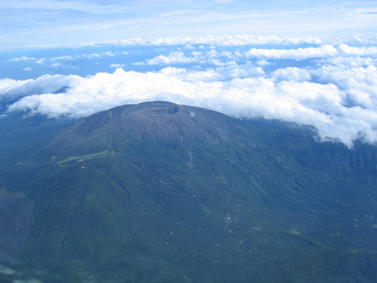
From the Air
Santa Ana Volcano (Ilamatepec) is at 13.853N, 89.630W, elevation 2,381 m (7,812 ft). It is the highest point in El Salvador and a prominent landmark for navigation across western El Salvador. The nested summit calderas and turquoise crater lake are visible from altitude. Nearby Coatepeque caldera lake lies to the south. Nearest major airport is El Salvador International (MSLP) approximately 65 km to the southeast. Be aware of potential volcanic gases and mountain weather including sudden cloud formation at summit level.