Santa María Volcano
The K'iche' Maya called it Gagxanul, the Naked Mountain, long before Spanish boots touched Guatemalan soil. The name fits. Santa María rises about 1,400 meters above the plain where Quetzaltenango sprawls, its cone stripped of the dense forest cover that blankets neighboring peaks. For thousands of years it stood so still that everyone, including the scientists, forgot it could move. Then, on October 24, 1902, it reminded them with one of the largest volcanic eruptions the modern world has ever seen.
Built by Collision
Santa María belongs to the Sierra Madre volcanic range running along Guatemala's western edge, separated from the Pacific Ocean by a broad coastal plain. The engine behind these mountains lies deep underground: the Cocos tectonic plate dives beneath the Caribbean Plate, generating the heat and pressure that feeds the Central America Volcanic Arc. Eruptions at Santa María began roughly 103,000 years ago. The cone grew in four distinct phases, the last ending around 25,000 years ago, after which the volcano settled into long silences punctuated by small lava flows. That quiet spell lasted so long that by the time European record-keeping arrived, Santa María appeared to be nothing more than an impressively tall, entirely harmless mountain.
The Day the Cone Broke Open
A seismic swarm in January 1902 gave the first warning. By April, a major earthquake had leveled parts of Quetzaltenango. Then, on October 24, the southwest flank of Santa María blew out. Over two days, the volcano ejected an estimated eight cubic kilometers of magma, producing a VEI-6 eruption, one of only three that large in the entire twentieth century, alongside Novarupta in 1912 and Mount Pinatubo in 1991. Pumice blanketed 273,000 square kilometers, and ash drifted 4,000 kilometers to San Francisco. The blast carved a crater roughly one kilometer across and 300 meters deep into the mountainside, a wound that is still clearly visible from the air. Darkness enveloped the surrounding region for 53 hours. Thousands of people died.
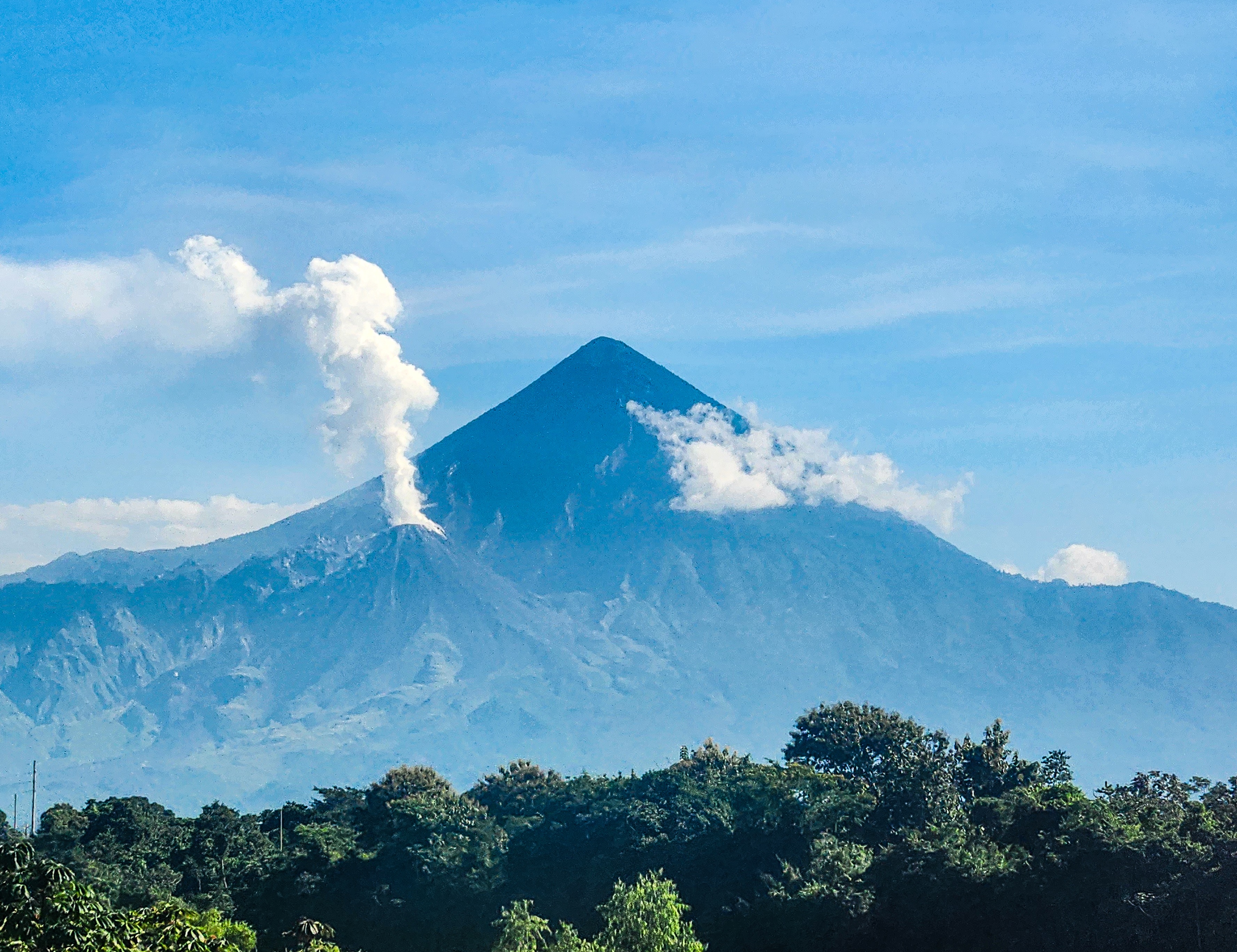
Santiaguito: The Volcano Within a Volcano
After twenty years of silence, something new began growing in the 1902 crater. Starting in 1922, a lava dome complex called Santiaguito pushed upward from the wound, and it has never stopped. More than one cubic kilometer of lava has erupted from Santiaguito so far, building four overlapping domes named El Caliente, La Mitad, El Monje, and El Brujo. The active vent today is El Caliente. Early lava was dacite, matching the chemistry of the 1902 blast, but by 1990 the composition had shifted to andesite, likely drawn from deeper layers of a stratified magma chamber. Activity runs in cycles spanning a decade or more: high-extrusion phases produce long lava flows, while quieter intervals yield short, collapsing flows near the vent. The most recent high phase ran from 2011 to 2015. Visitors who hike to Santa María's summit can watch Santiaguito erupt with near-daily regularity.
Living in the Shadow
For the communities below Santa María, the danger is constant and comes in many forms. Lahars, fast-moving rivers of volcanic debris mixed with rainwater, are the most frequent threat, surging down river valleys every rainy season. The town of El Palmar, just ten kilometers from Santiaguito, has been destroyed by lahars twice and was ultimately relocated to Nuevo El Palmar. Roads, bridges, and infrastructure along the rivers have been repeatedly damaged, with lahar deposits reaching all the way to the Pacific Ocean. Scientists also watch a longer-term hazard: the 1902 crater left the southern flank of Santa María severely oversteepened above the growing Santiaguito dome. A strong earthquake or large eruption could trigger a catastrophic landslide covering up to 100 square kilometers. The possibility, while considered unlikely in the near term, keeps this mountain on the Decade Volcano list, a designation identifying it as a priority target for volcanological research and hazard mitigation.
From the Air
Located at 14.756°N, 91.552°W in Guatemala's western highlands, summit elevation approximately 3,772 meters (12,375 feet). The 1902 crater scar and active Santiaguito dome complex are visible on the southwest flank, often producing steam and ash plumes. Nearest major airport is Quetzaltenango (MGQZ). Approach from the south for the best view of the crater and dome complex. Maintain safe altitude above 15,000 feet; volcanic emissions and orographic turbulence are common. The Sierra Madre chain stretches northwest and southeast with numerous peaks above 3,000 meters.