Saratoga Passage
The water between Whidbey Island and Camano Island carries the name of a warship that never sailed it. Saratoga Passage was named by Charles Wilkes during his 1838-1842 United States Exploring Expedition, honoring the USS Saratoga, Thomas MacDonough's flagship at the Battle of Lake Champlain during the War of 1812. Wilkes had originally named the neighboring island MacDonough Island, but five years later, when British naval officer Henry Kellett reorganized the Admiralty charts, that name was erased and replaced with Camano, honoring the Spanish explorer Jacinto Caamano. Wilkes' name for the passage, however, stuck. In the Pacific Northwest, water holds its names longer than land does.
Charting the Passage
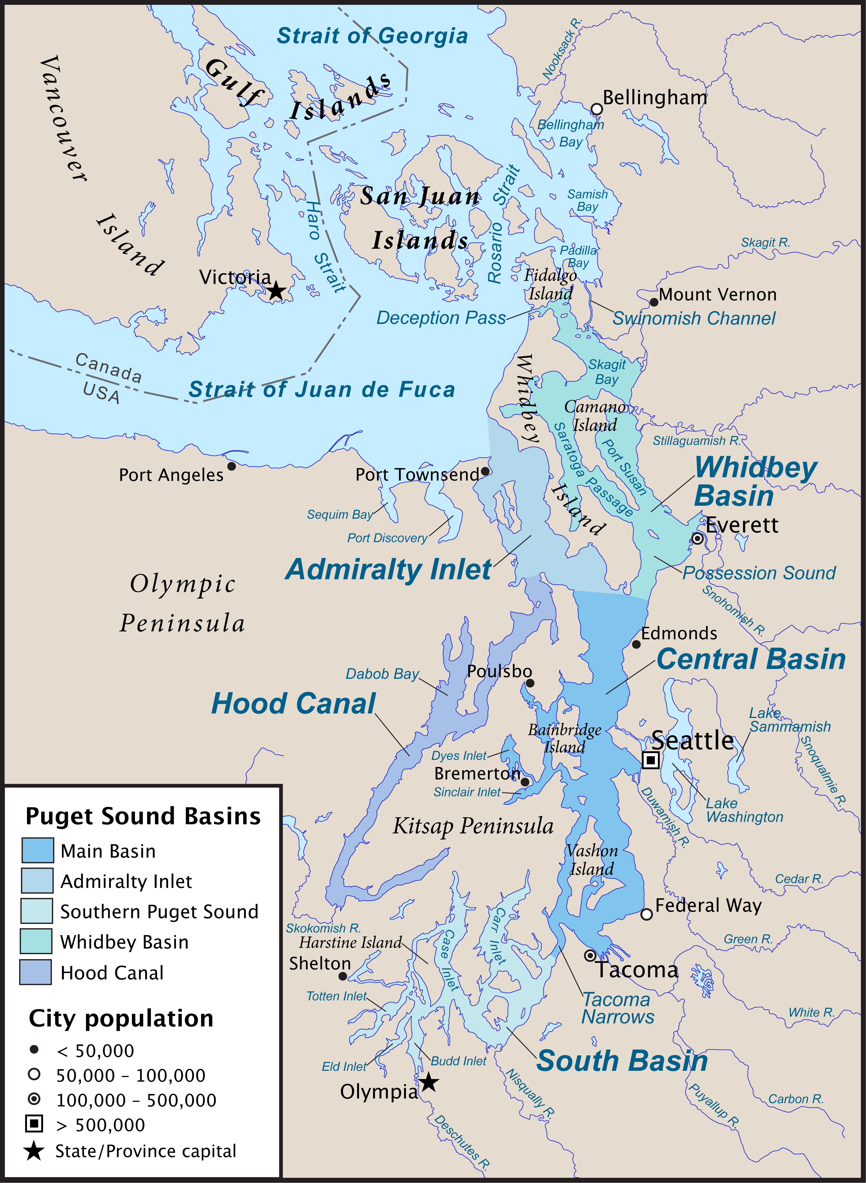
Saratoga Passage extends 18 miles in a northwesterly direction from its entrance between Sandy Point on the Whidbey side and Camano Head on the opposite shore. At the southeastern entrance, the water drops to about 600 feet. By the time it reaches Crescent Harbor at its northern end, the depth has shallowed to roughly 90 feet. The passage connects to Penn Cove and leads east into Skagit Bay, creating a network of protected waterways that made this area valuable to both native peoples and European settlers. George Vancouver had sailed through in 1792 and named the entire waterway Port Gardner, honoring Vice-Admiral Sir Alan Gardner. That name migrated south and now belongs to the bay and harbor of Everett. Port Susan, the water east of Camano Island, was also named by Vancouver, honoring Lady Gardner, Sir Alan's wife. The geography is a palimpsest of Spanish, British, and American claims written in water.
Forested Banks and a Single Town
Most of the waterfront along Saratoga Passage rises into high banks of forested sand and clay, giving the passage a walled quality from the water. On the Whidbey side, four low-bank communities break the pattern: Sandy Point, Langley, Bells Beach, and Fox Spit. Of these, only Langley qualifies as a city, making it the sole incorporated municipality on either island's shore along the entire 18-mile stretch. The beaches are gravel and sand, and at low tide the water retreats a considerable distance, exposing flats where clam diggers and shorebirds compete for the same quarry. The passage feels surprisingly uncrowded for a waterway so close to Seattle, a quality that has made it a favorite of recreational boaters and kayakers who prefer protected water to the open swells of the Strait of Juan de Fuca.
What the Water Lost
Dungeness crab, clams, and flatfish remain abundant in Saratoga Passage. But the salmon are largely gone. Strong runs once passed through these waters on their way to the rivers of the mainland, and the fishing sustained both indigenous communities and settler economies for generations. The salmon's decline brought the collapse of the candlefish and herring populations that had served as bait, unraveling an entire food web that had once defined the passage's ecology. Most fishing in southern Whidbey has shifted to the island's western shore: Possession Sound, Mutiny Bay, Double Bluff. The passage is quieter now than it was a century ago, the silence of absent fish replacing the noise of a once-thriving fishery.
Traffic and Shelter
Despite its relative calm, Saratoga Passage carries considerable maritime traffic. Recreational boats and fishing vessels make up the majority, but tugboats bound for Deception Pass or the Swinomish Channel pass through regularly, and high-speed passenger ferries running between Seattle, Victoria, and Friday Harbor use the passage and Deception Pass as an alternative route when rough weather makes the Strait of Juan de Fuca dangerous. The passage provides a sheltered corridor through island geography that would otherwise require long detours through exposed open water. For centuries, this protective quality has drawn travelers: indigenous canoe routes, early settler supply ships, and now weekend sailors all using the same geography for the same reason. The islands block the wind, the depths are navigable, and the water between Whidbey and Camano remains, as it has always been, a good place to pass through.
From the Air
Saratoga Passage runs NW-SE between Whidbey Island (west) and Camano Island (east), centered at approximately 48.15°N, 122.54°W. The passage is visible as a distinct channel separating the two islands. Langley is the small town on the Whidbey shore at the southern end. At the northern end, the passage opens into Skagit Bay. Best viewed from 3,000-5,000 ft AGL. Nearest airports: W10 (Whidbey Airpark, 5 nm W), KNUW (NAS Whidbey Island, 8 nm NW), KPAE (Paine Field, 18 nm S).