Sarmizegetusa Regia
Nobody knows exactly what the name means. Scholars have proposed "Citadel on the Rock," "City of the Warm River," "Palace Illuminating the World of Life," and half a dozen other translations from a language that left no dictionary behind. What is certain is that Sarmizegetusa Regia -- perched at 1,200 meters in Romania's Orastie Mountains -- was the capital, religious heart, and final stronghold of the Dacian civilization. When Emperor Trajan finally conquered it after two brutal wars, he demolished the citadel. Then Emperor Hadrian did something revealing: he named the new Roman capital Sarmizegetusa too, 40 kilometers away, because the original name still carried that much weight.
Running Water on a Mountaintop
The fortress sat on a hill commanding views in every direction, its hexagonal citadel walls -- 3 meters thick, up to 10 meters tall -- built in the distinctive murus dacicus technique of stone faces braced with timber beams. But Sarmizegetusa was far more than a military installation. Below the citadel, civilian settlements spread across artificial terraces covering 3 kilometers, with dwellings, workshops, warehouses, barns, and water reservoirs. Ceramic pipes channeled running water to the residences of the nobility -- a plumbing system that would have been remarkable in a lowland city, let alone one perched on a Carpathian summit. The archaeological inventory found at the site demonstrates a society with a surprisingly high standard of living, one that had absorbed Greek and Roman knowledge without losing its own identity.
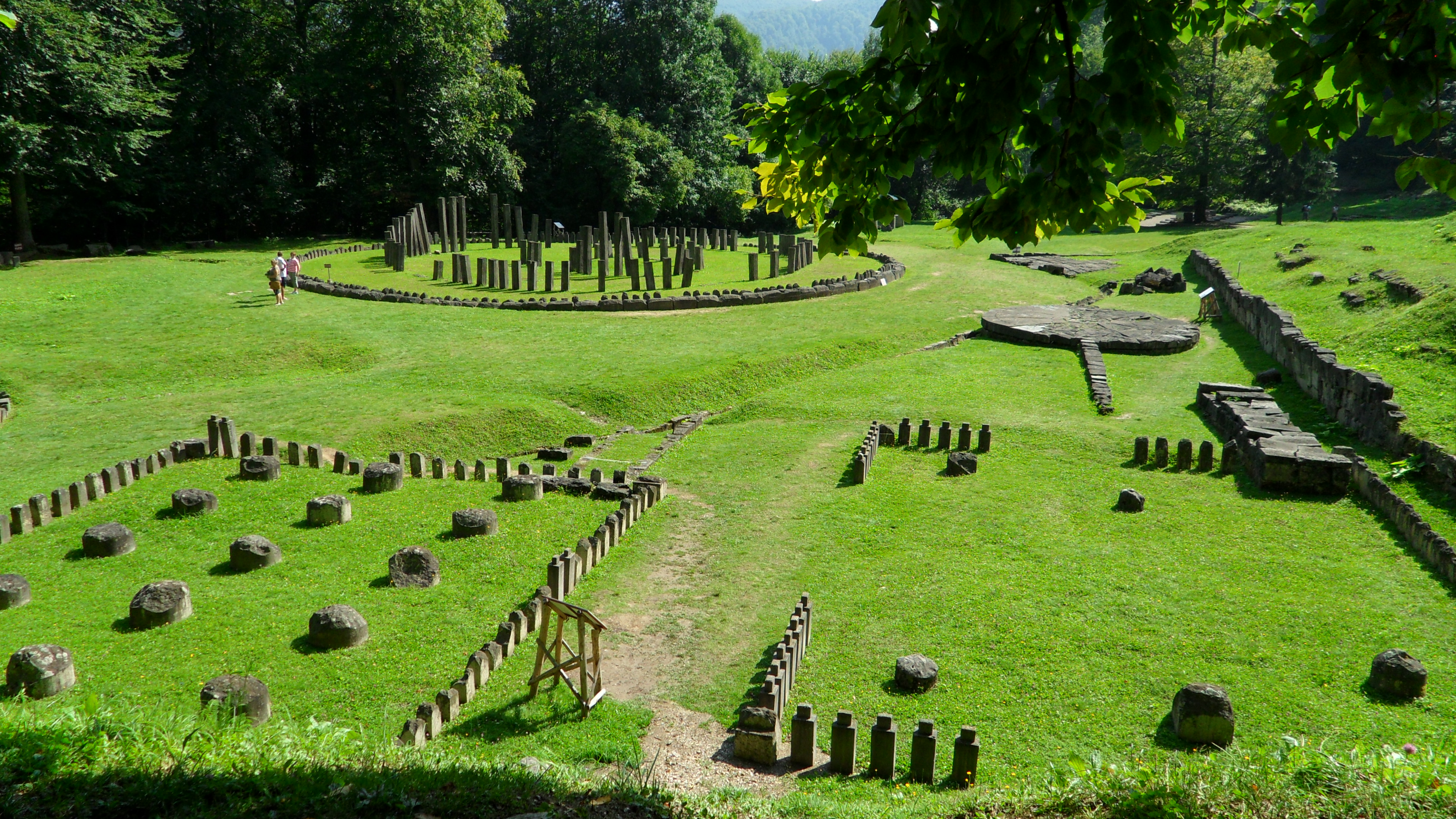
The Sanctuary That Echoes Stonehenge
East of the citadel gate, connected by a paved road, stood the sacred zone. Among its rectangular temples -- seven or eight, though Roman destruction makes the exact count uncertain -- the most striking structure is the great circular sanctuary. Timber posts arranged in a D-shape stood within a timber circle, itself ringed by a low stone kerb, in a layout that bears a genuine resemblance to Stonehenge. Nearby, an artifact called the Andesite Sun appears to have served as a sundial, evidence that Dacian contact with Hellenistic Greece had introduced astronomical and geometric knowledge. The god Zalmoxis and his chief priest held central roles in Dacian society, and the scale of these sacred structures -- among the largest circular and rectangular sanctuaries in the Dacian world -- suggests a civilization in which religion, science, and political power were deeply intertwined.
What the Earth Gave Up
Archaeology at Sarmizegetusa has yielded finds that rewrite assumptions about "barbarian" societies on Rome's frontier. A medical kit in a brassbound wooden box contained a scalpel, tweezers, powdered pumice, and miniature pharmaceutical pots. A massive vase -- 0.6 meters tall, over a meter across -- bore an inscription in the Roman alphabet: DECEBAL PER SCORILO, meaning "Decebalus, son of Scorilus." Gold coins stamped KOSON turned up among the ruins. North of the sanctuary, smithies produced some 400 metallic artifacts: scythes, sickles, hoes, plowshares, carpenters' tools, as well as weapons including the curved Dacian scimitar and metre-long tongs. These were not primitive hill people. They were skilled metalworkers, literate administrators, and sophisticated builders who happened to stand in Rome's path.
Conquest and Erasure
Sarmizegetusa reached its peak under King Decebalus, who turned the citadel and its ring of six satellite fortresses into a defensive system formidable enough to force Rome into two separate wars. The First Dacian War ended in AD 102 with partial Roman victory; the walls were partly dismantled but Decebalus remained on his throne. The second war, in AD 105-106, ended the kingdom. Roman forces besieged and took the capital, then systematically dismantled it -- not just militarily but symbolically, tearing down the physical architecture of Dacian power. A military garrison replaced the sacred precincts. Yet the name survived, transplanted to the new Roman capital 40 kilometers south. Today, Sarmizegetusa Regia is a UNESCO World Heritage Site, but preservation remains a struggle. In 2011, a construction company bulldozed part of the site to build a parking lot without archaeological supervision. The citadel now sits under 24-hour surveillance to deter looters and vandals.
From the Air
Located at 45.62N, 23.31E atop a 1,200-meter peak in Romania's Orastie Mountains. The site is in dense Carpathian forest; from altitude, look for cleared terraces and stone foundations on a prominent hilltop. Mountain weather can be unpredictable. Nearest major airport is Sibiu International (LRSB), approximately 70 km east. The Roman successor city of Ulpia Traiana Sarmizegetusa lies about 40 km south in the Hateg Depression, also visible from altitude as archaeological ruins in open farmland.