Sarushima: The Phantom Fortress in Tokyo Bay
A white monkey saved a holy man here, or so the legend goes. In 1253, the Buddhist monk Nichiren was caught in a storm while crossing Tokyo Bay. His boat washed ashore on a small, uninhabited island, and according to tradition, a white monkey appeared from the trees to guide him to shelter in a cave. The island has carried the name ever since: Sarushima, Monkey Island. There are no monkeys here now. There never were, really, apart from that one spectral guide. What the island does hold, hidden beneath a canopy of subtropical overgrowth, is something far more surprising -- an elaborate military fortress built to be invisible from the sea.
A Secret Carved from Stone
The genius of Sarushima's fortifications lies in their concealment. When the Tokugawa shogunate built the island's first artillery battery in 1847, they were responding to increasing Western encursions into Japanese waters. Six years later, Commodore Matthew C. Perry's Black Ships would anchor nearby, and Perry himself would name this rock "Perry Island." But the real fortress came after the Meiji Restoration. In 1877, the island passed to the Imperial Japanese Navy, and in 1881 the Army took over and began construction in earnest. By 1884, they had created something remarkable: a fortress built by digging down from the island's summit, carving out tunnels, gun batteries, and powder magazines entirely below the surface. From the water, passing ships saw only green hillside. The cannons hidden within could open fire before an enemy even knew the island was armed.
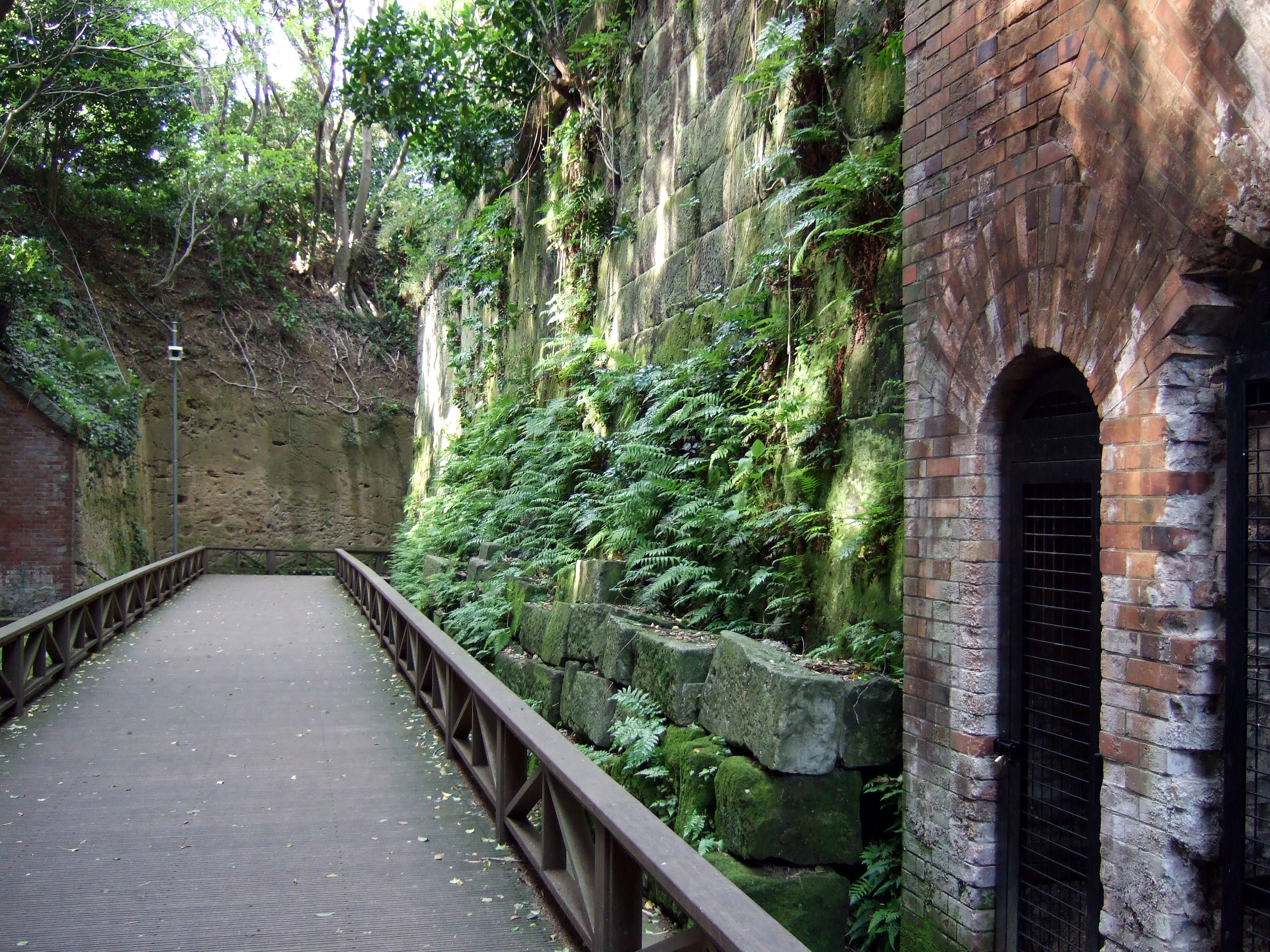
Brick and Vine
Walk through Sarushima today and the effect is startling. Brick-lined tunnels stretch through the island's interior, their arched ceilings stained with moisture, their walls built in the French architectural style that Japan's military adopted during the Meiji era. Gun battery recesses open onto views of the bay, their iron hardware long since removed but the stone emplacements intact. Abandoned watchtowers stand half-swallowed by vegetation. The fortified pathways that once connected firing positions now serve as atmospheric hiking trails, the red brick softened by decades of moss and creeping vines. The combination of military ruin and lush overgrowth has drawn comparisons to Studio Ghibli landscapes -- the island feels like a place where nature is slowly, patiently reclaiming what humans built.
Wars Hot and Cold
Sarushima's military career spanned nearly a century. During the Edo period, it served as the shogunate's first line of defense at the mouth of Tokyo Bay. After the Meiji Restoration in 1868, the island was incorporated into the Yokosuka Navy Yard complex and upgraded with modern fortifications. During World War II, the Japanese military added new artillery points around the older structures, pressing the island back into active service as a coastal defense position. When American forces occupied the area in 1945, they stripped the island of all functional military equipment, ending Sarushima's life as a fortress. The island remained under American control until 1961, when it was returned to Japan. The tunnels, bunkers, and gun emplacements were left standing, empty monuments to a century of coastal defense.
Barbecues Among the Ruins
The transformation from military installation to public park began after the island's return. Today, Sarushima is uninhabited and accessible only by a short ferry ride from Yokosuka's Mikasa Park. The southern beach -- a rare stretch of natural sand in urbanized Tokyo Bay -- draws swimmers and sunbathers in summer. Fishing is popular along the rocky shoreline. The island's most unexpected feature may be its barbecue areas, where visitors grill seafood within sight of crumbling fortifications. A small Buddhist statue sits enshrined in the cave where legend says Nichiren sheltered from the storm nearly eight centuries ago. The island is tiny -- you can walk its perimeter in well under an hour -- but it packs a remarkable density of history, atmosphere, and natural beauty into its compact footprint. It remains the only natural island in all of Tokyo Bay, a distinction that grows more remarkable with every passing decade of urban development on the surrounding shores.
From the Air
Located at 35.286°N, 139.694°E in Tokyo Bay, approximately 1 nautical mile off the coast of Yokosuka. The island is small but distinct -- the only visible natural landmass in the bay south of the reclaimed port areas. Best viewed at 1,500-3,000 feet AGL on approach from the east or north. The nearby Yokosuka naval facilities (both U.S. and JMSDF) are prominent landmarks along the Miura Peninsula coastline. Tokyo Haneda (RJTT) lies approximately 25 nautical miles to the north-northwest. Yokota Air Base (RJTY) is further inland. The Uraga Channel narrows visibly just south of the island, marking the entrance to Tokyo Bay.