Scarborough Shoal
The highest point is 1.8 meters above sea level. That is all it takes, apparently, to ignite a geopolitical crisis that draws in superpowers, triggers international arbitration, and displaces entire fishing communities. Scarborough Shoal is a triangle-shaped chain of reefs and rocks enclosing a lagoon, 150 square kilometers of water ringed by coral that barely qualifies as land. It sits 119 nautical miles west of Luzon in the Philippines, named after a British merchant ship that ran aground here in 1748 and somehow managed to sail on to China. The shoal has gone by many names since: Bajo de Masinloc to the Spanish, Huangyan Island to China, Panatag Shoal in Filipino. Each name is a flag planted in language, a claim staked before the lawyers ever arrived.
A Rock by Any Other Name
The atoll's English name belongs to Captain Philippe D'Auvergne of the East India Company, whose ship Scarborough grounded on one of the rocks on September 12, 1748. But the shoal appears on charts far older than that. A 1734 map by the Spanish Jesuit Pedro Murillo Velarde shows three features off the coast of central Luzon labeled Galit, Panacot, and Lumbay, words that translate from Filipino as anger, threat, and gloom. In 1808, the Spanish colonial government published the Carta General del Archipelago Filipino, placing Scarborough Shoal within Philippine territory. Chinese scholars trace their claim to the Yuan dynasty astronomer Guo Shoujing, who in 1279 conducted a survey at a point called Nanhai, though whether that location was the shoal, the Paracels, or central Vietnam remains debated by historians. The Republic of China classified the atoll as part of the Zhongsha Islands in 1935 and gave it the name Minzhu Jiao in 1947.
The Standoff That Changed Everything
Before April 2012, Filipino and Chinese fishermen operated around the shoal with little interference from either government. Then the Philippine Navy attempted to apprehend eight Chinese fishing vessels near the reef, and China responded by sending maritime surveillance ships. What followed was a months-long standoff that reshaped the balance of power in the South China Sea. The Philippines claimed that under a deal mediated by the United States, both nations agreed to withdraw. Manila pulled its ships back. Beijing did not. By July 2012, China had erected a barrier at the entrance to the lagoon. Chinese government vessels began turning away Filipino boats. The access that fishing communities in Zambales and Pangasinan had relied on for generations was suddenly restricted, forcing fishermen to travel farther offshore at higher cost and greater risk.
Law of the Sea
In January 2013, having exhausted diplomatic options, the Philippines initiated arbitration against China under the United Nations Convention on the Law of the Sea. China refused to participate. On July 12, 2016, the Permanent Court of Arbitration ruled decisively: China's historic rights claims within its nine-dash line had no legal basis. The tribunal classified Scarborough Shoal as a rock under Article 121(3), meaning it generates no exclusive economic zone, and it affirmed that both Filipino and Chinese artisanal fishermen held traditional fishing rights at the shoal. The ruling did not address sovereignty directly. China rejected the decision, calling it ill-founded. Taiwan rejected it too. The arbitration established legal principles but changed nothing on the water. Chinese Coast Guard vessels continued patrolling the lagoon entrance, and the shoal remained under de facto Chinese control.
Water Cannons and Floating Barriers
The years after the ruling brought escalation, not resolution. In 2014 and again in 2015, Chinese Coast Guard vessels fired water cannons at Filipino fishing boats and seized their catch. By April 2021, an estimated 287 Chinese fishing vessels were operating at the shoal, suspected of taking more than 260 tons of fish. In April 2024, Chinese Coast Guard ships fired water cannons at a Philippine Coast Guard vessel and a fisheries ship accompanied by journalists, causing damage. Then in August 2025, an incident that seemed almost scripted for its absurdity: a China Coast Guard cutter collided with a Chinese Navy destroyer while both were attempting to expel a Philippine ship, the BRP Suluan. The Philippine crew offered assistance by radio. No response came. The 42 crew members of the Suluan were later awarded the Coast Guard Bronze Cross Medal. In September 2025, China announced the creation of the Huangyan Island National Nature Reserve on the shoal, prompting fresh protests from Manila.
The Fishermen in Between
Lost in the diplomatic cables and naval maneuvers are the people who depend on these waters for a living. Scarborough Shoal is a critical fishing ground for coastal communities across Zambales and Pangasinan provinces. After 2012, restricted access caused catch volumes to fluctuate, and the economic damage radiated outward through supply chains that had operated for generations. When Philippine President Rodrigo Duterte pursued warmer ties with Beijing in 2016, China granted Filipino vessels some access for fishing. But the arrangement was fragile. Reports from 2018 described Chinese Coast Guard personnel taking Filipino fishermen's catch and paying them two bottles of mineral water, worth about twenty Philippine pesos, for every three thousand pesos' worth of fish. The shoal remains what it has always been: a place where the sea provides, when politics allows it.
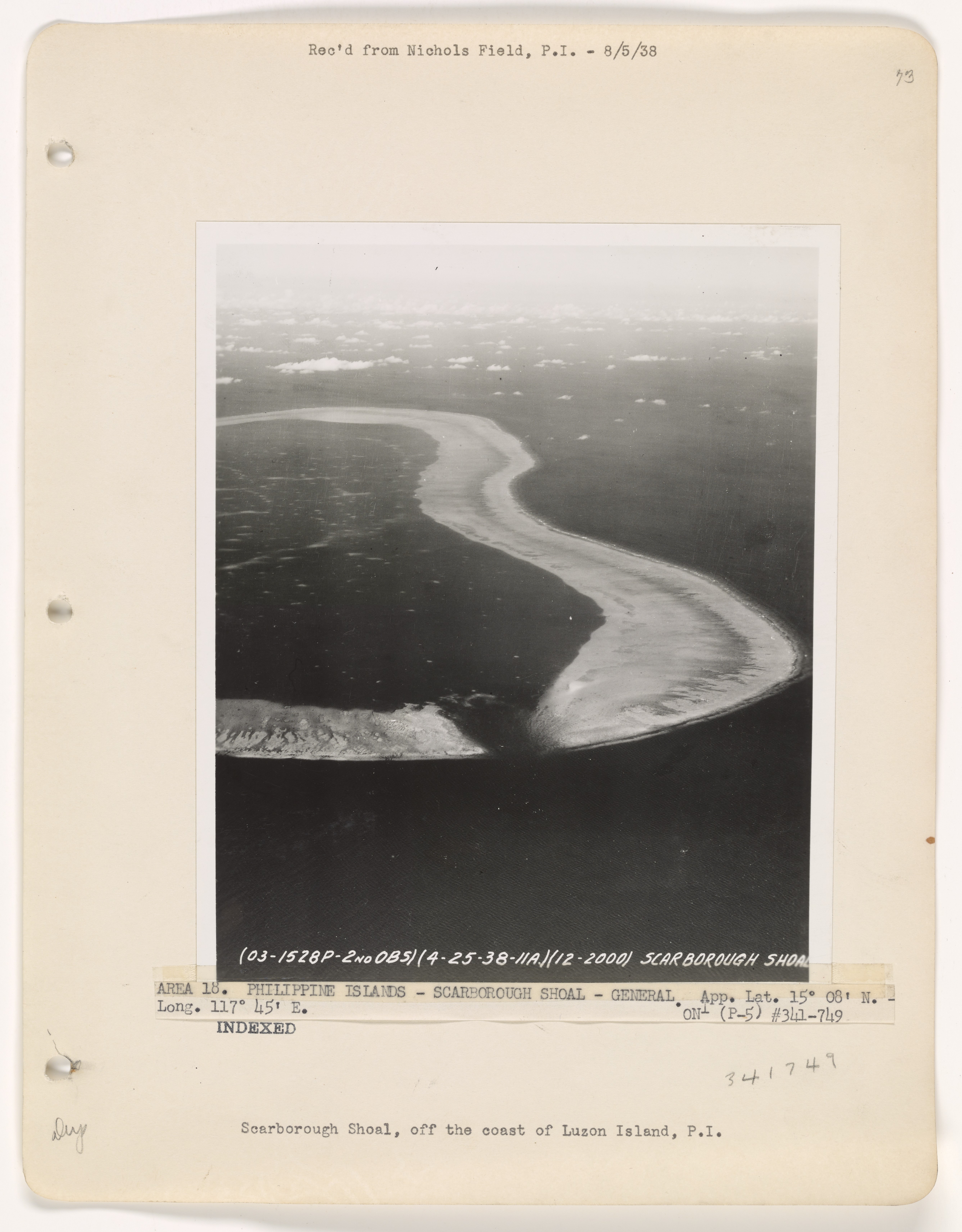
From the Air
Scarborough Shoal is located at approximately 15.18N, 117.77E, about 119 nautical miles west of Luzon in the Philippines. The atoll forms a visible triangular shape from altitude, with a perimeter of 46 km enclosing a turquoise lagoon. South Rock, the highest point at 1.8 meters, is difficult to spot from high altitude, but the reef ring and lagoon contrast sharply against the deep ocean. The nearest major airport is Clark International (RPLC) on Luzon, roughly 220 km east. Manila's Ninoy Aquino International Airport (RPLL) is about 350 km southeast. Expect Chinese military and coast guard vessel presence. The area falls within contested airspace and is under de facto Chinese maritime control.