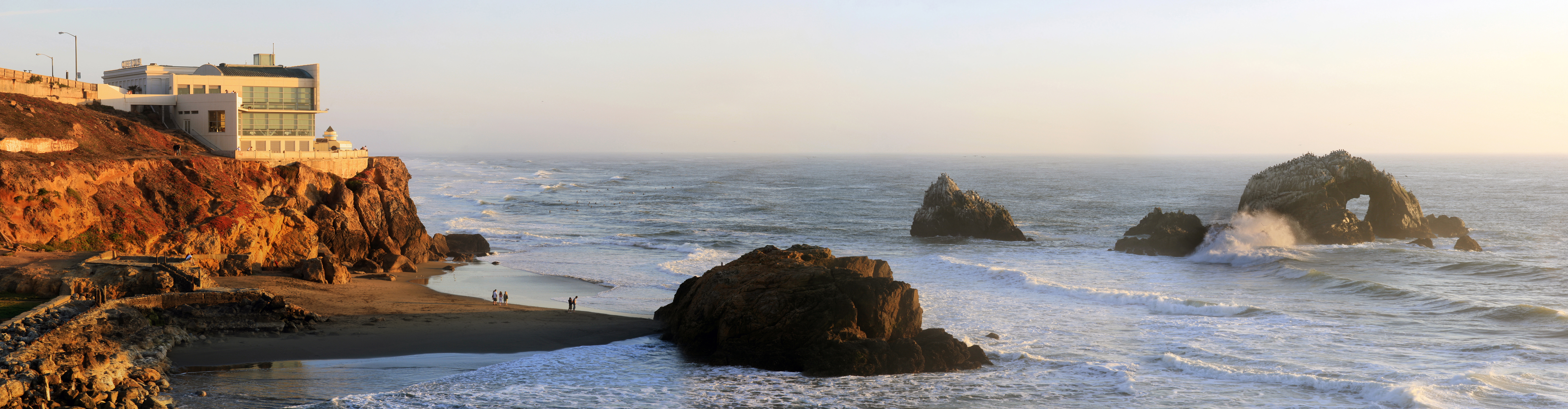
Seal Rocks
The barking carries across the water before you see them. Hundreds of sea lions -- Steller's and California -- sprawl across the wave-lashed rock formations just offshore from Lands End, their calls a foghorn chorus that has greeted every ship approaching San Francisco's western shore for centuries. These small rocky islands, visible from the Cliff House and the ruins of the Sutro Baths, are among the oldest continuously occupied wildlife habitats in the city. They are also a reminder of what San Francisco looked like before the grid arrived: barren sand dunes stretching from the beach to Twin Peaks, with nothing between the sea lions and the inland hills but wind.
Ice Age Remnants
Five thousand years ago, these rocks were not offshore islands at all. During the last ice age, the coastline extended eight to twenty-five miles further west, and the formations now called Seal Rocks were inland features of a much larger landmass. As glaciers melted and sea levels rose, the Pacific swallowed the coastal plain and left these rocky outcrops stranded in the surf. The geology beneath the adjacent Ocean Beach tells the story in layers: placed fill from a century of construction, dune sands, and below that the Colma and Merced Formations -- poorly sorted sandy deposits laid down during earlier periods of high sea levels. Bedrock lies 350 feet or more beneath the surface. The rocks themselves are part of the northern extension of the Santa Cruz Mountains, the same geological spine that forms the entire San Francisco Peninsula.
The Sea Lions' Domain
Both Steller's sea lions and California sea lions use the rocks as haul-out sites, resting between foraging trips in the rich waters of the outer coast. The larger Steller's, which can weigh over 2,000 pounds, are the ones whose deep bellowing carries the farthest. California sea lions are smaller and more numerous, their higher-pitched barking providing the constant background noise visitors hear from the Cliff House overlook. Despite being called Seal Rocks, no true seals typically inhabit the formation -- both species are technically sea lions, members of the family Otariidae, distinguished from seals by their external ear flaps and ability to rotate their hind flippers forward for walking on land. The formations and their wildlife are protected within the Golden Gate National Recreation Area.
The View from Above
Carleton Watkins photographed the rocks around 1868, capturing the Cliff House perched above while sea lions covered every available surface below. Alexander Gardner may have photographed them in 1869 for his series documenting the Kansas Pacific Railway route across the continent, titling his image the "last scene of all in this strange, eventful history" -- a Shakespeare quote marking the Pacific as the final frontier. The first known map of the coastline, made by the United States Coast Survey in 1852, describes the area as entirely unaltered by humans. Within decades, Adolph Sutro would build his baths, the Cliff House, and the rail line along the cliffs. Today only the rocks and the sea lions remain unchanged, the oldest residents of a neighborhood that has reinvented itself above them.
From the Air
Seal Rocks sits at 37.78N, -122.52W, just offshore from the Cliff House at the northwestern corner of San Francisco. From the air, the dark rocky formations are clearly visible in the surf zone, often covered with the brown and tan forms of hauled-out sea lions. The adjacent Sutro Baths ruins and Ocean Beach provide context. The rocks mark the transition from the Pacific coast to the entrance of the Golden Gate. Nearest airports: KSFO 14nm south, KOAK 13nm east. Best viewed at low altitude on a clear day.