Sedona
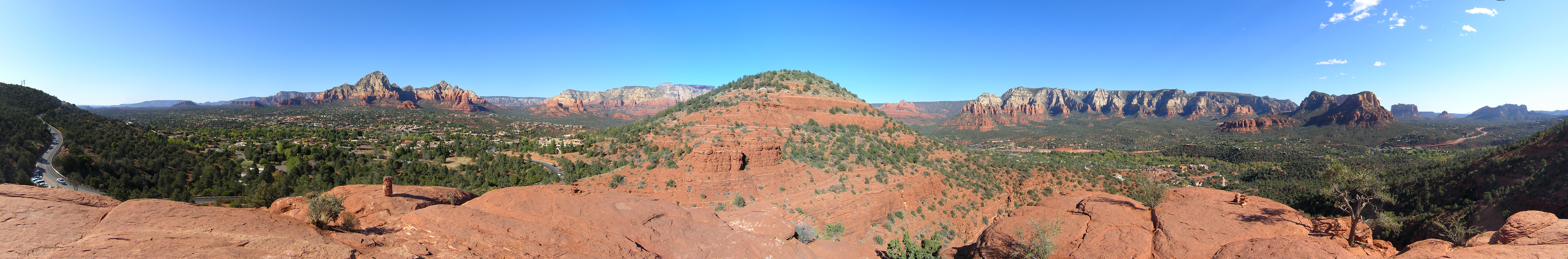
Sedona exists at the intersection of geology and belief. The red rock formations surrounding this Arizona town - sculpted by millions of years of erosion into spires, buttes, and natural cathedrals - attract two million visitors annually, some drawn by the pure visual spectacle, others convinced the area contains unusual spiritual energy. The Yavapai and Apache peoples considered these lands sacred long before New Age practitioners declared certain spots 'vortexes' of electromagnetic power. Whether you come for hiking, mountain biking, Jeep tours, photography, art galleries, or chakra alignment, Sedona delivers landscapes that feel genuinely otherworldly. The red rock derives its color from iron oxide - rust - in the Permian-era sandstone, and when the setting sun catches these formations, they blaze with colors that no photograph fully captures. This is Arizona at its most Arizona: vast desert vistas, ancient Native American ruins, Spanish colonial history, and Western legends, all set against a backdrop that looks like another planet.
Red Rock Country
The geology that makes Sedona famous began 330 million years ago when this region lay beneath a shallow sea. Layer upon layer of sediment accumulated over geological time: sandstone, limestone, mudstone, compressing and solidifying into rock thousands of feet thick. The uplift of the Colorado Plateau raised these layers above sea level; erosion carved them into the formations we see today. Cathedral Rock, Bell Rock, Courthouse Butte, Coffee Pot Rock - each named for what imagination sees in its shape - represent harder rock left standing while softer material weathered away. The red color comes from iron oxide in the Schnebly Hill Formation, named for the family whose road provides some of Sedona's best sunset viewpoints. The geology here differs from the Grand Canyon's deeper, older exposures, but the erosion processes are similar: water, frost, and time sculpting stone into impossible shapes.
Vortex Phenomena
Beginning in the 1980s, Sedona became famous - or infamous - as a center for New Age spirituality. Practitioners identified four primary 'vortex' sites where the earth's energy supposedly concentrates: Airport Mesa, Cathedral Rock, Bell Rock, and Boynton Canyon. The theory holds that these locations produce measurable electromagnetic anomalies that affect human consciousness, promote healing, or facilitate meditation. Scientists find no evidence supporting these claims; the vortex phenomenon is better understood as a cultural rather than geological feature. Yet the belief persists, generating tourism, supporting businesses, and drawing seekers who report genuine experiences at these sites. Whether you attribute that to energy fields or to the psychological impact of stunning natural beauty in a peaceful setting, Sedona's vortex reputation has become inseparable from its identity.
Ancient Inhabitants
Long before vortex seekers arrived, the Sinagua people built cliff dwellings throughout Sedona's red rock canyons. Honanki and Palatki heritage sites preserve their architecture and rock art, accessible via dirt roads north of town. The Sinagua farmed the Verde Valley from roughly 650 to 1400 CE before dispersing to other pueblos; their descendants may include today's Hopi and Zuni peoples. Later, Yavapai and Apache bands hunted and gathered here, considering specific formations sacred. Spanish missionaries arrived in the 1600s; American settlers followed in the 1800s. The town itself dates only to 1902, named for the postmaster's wife. But human connection to this landscape extends back millennia, and traces of that history remain visible for those who know where to look.
Outdoor Adventures
Sedona offers some of the best hiking and mountain biking in the American Southwest. Trails range from easy walks along Oak Creek to demanding scrambles up Cathedral Rock's slickrock slopes. The Devil's Bridge trail leads to a natural sandstone arch; Soldier Pass features multiple sinkholes and ancient ruins. Mountain bikers come specifically for the world-class singletrack, technical terrain through red rock landscapes unlike anywhere else. Jeep tours access backcountry areas closed to regular vehicles, bouncing up Broken Arrow trail or along Schnebly Hill Road. Oak Creek Canyon north of town provides swimming holes at Slide Rock State Park, where natural waterslides have polished the creek bottom smooth. The Forest Service requires Red Rock passes for parking at most trailheads - available at local vendors and online.
Practical Sedona
Sedona sprawls across three areas: Uptown Sedona with its concentration of galleries and tourist shops, West Sedona with more local businesses and services, and the Village of Oak Creek to the south. Phoenix Sky Harbor airport lies two hours south via Interstate 17 and Highway 179, itself designated a National Scenic Byway through the red rock terrain. Flagstaff to the north provides an alternative gateway, connected by the dramatic switchbacks of Oak Creek Canyon along Highway 89A. Accommodation ranges from camping at Forest Service sites to luxury resorts; prices run high during peak seasons. The arts scene that began with sculptors and painters drawn to the light has expanded to nearly a hundred galleries. Restaurants have improved dramatically as the town evolved from roadside stop to destination. Plan visits for spring or fall; summer brings extreme heat, winter occasional snow.
From the Air
Located at 34.87°N, 111.76°W in north-central Arizona. Sedona is visible from altitude as a developed area surrounded by distinctive red rock formations in the Verde Valley. Cathedral Rock, Bell Rock, and other major formations are identifiable landmarks. The winding Oak Creek Canyon is visible extending north toward Flagstaff. Phoenix Sky Harbor International Airport (PHX) lies 120 miles south. Flagstaff Pulliam Airport (FLG) is 28 miles north. The Verde River winds through the valley to the southwest.