Sedona, Arizona
Her mother made the name up because it sounded pretty. That is the entire origin story of Sedona, Arizona, one of the most photographed landscapes in the American West. When Theodore Carlton Schnebly needed a name for the new post office he was establishing in 1902, he submitted his wife's name, Sedona, a word her mother Amanda Miller had simply invented. There were 55 residents at the time. Today over 10,000 people live among the pink sandstone towers and mesas of the northern Verde Valley, and roughly three million visitors arrive each year to see the formations that glow amber and rose when the desert sun hits them at the right angle. The geology is 270 million years old. The town is barely older than a century. The tension between ancient landscape and recent human presence is the thing that makes Sedona endlessly interesting.
Stone Written in Deep Time
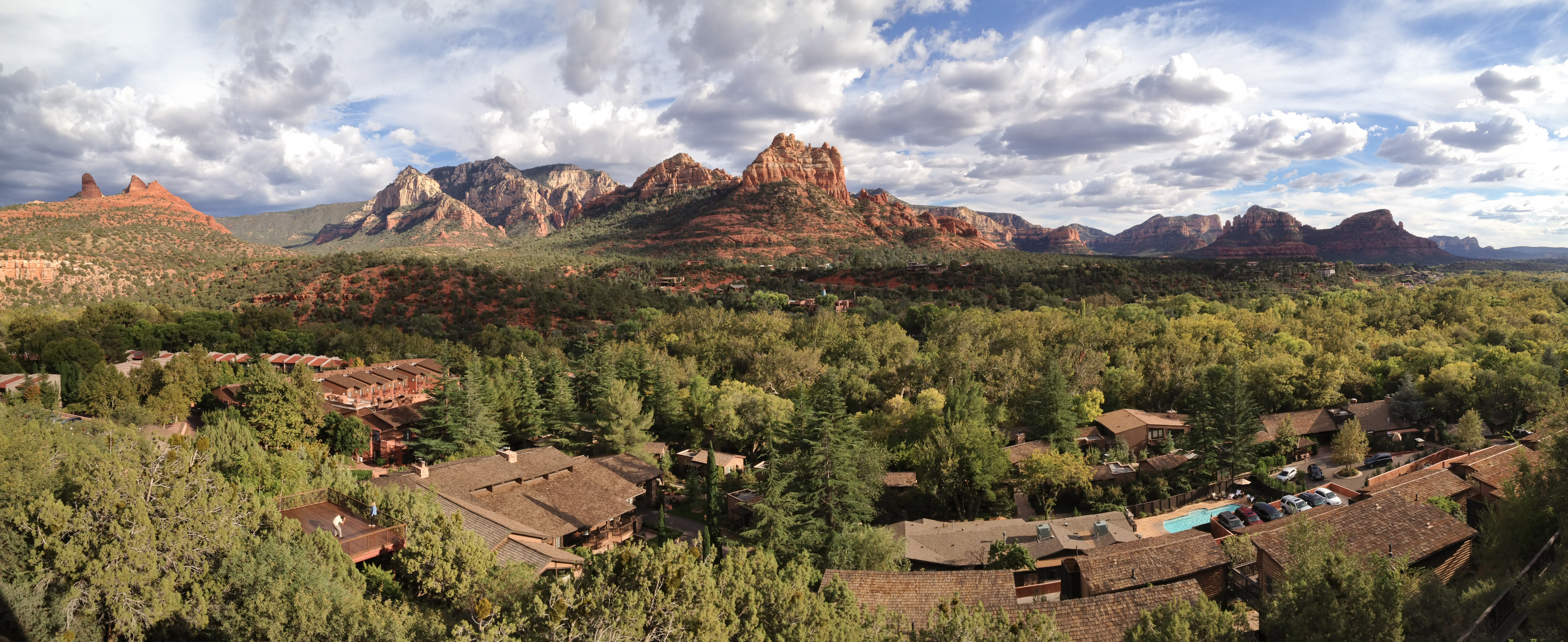
The pink and red rock that defines Sedona is a single geological unit: the Schnebly Hill Formation, a thick layer of sandstone deposited during the Permian Period, roughly 270 million years ago. It belongs to the Supai Group and is found only in the Sedona vicinity. Over millions of years, erosion carved this formation into the landmarks that now carry names both sacred and whimsical: Bell Rock, Cathedral Rock, Capitol Butte, Courthouse Butte, the Seven Sacred Pools, the Devil's Kitchen Sinkhole, and Wilson Mountain, the tallest of them all. The city sits within the Coconino National Forest, straddling the county line between Coconino and Yavapai. Its climate is cold semi-arid, classified BSk, making it a high desert with mild winters and warm summers. The vegetation is interior chaparral and Great Basin conifer woodland, and the landscape feels simultaneously lush and stark depending on the season and the angle of light.
Arizona's Little Hollywood
From 1923 into the 1970s, Sedona hosted more than sixty Hollywood productions. Major westerns including Angel and the Badman, Johnny Guitar, 3:10 to Yuma, and Broken Arrow were filmed against the pink rocks, though audiences were told they were seeing Texas, California, Nevada, or the Canadian border. The cinematic legacy faded when production economics shifted, but Sedona's relationship with the arts only deepened. The Sedona Arts Center, founded in 1958, is the oldest in northern Arizona. Surrealist painter Max Ernst moved to Sedona when the population was under a hundred people, bringing international art-world attention to a place most Americans had never heard of. His wife Dorothea Tanning, a painter, writer, and feminist icon, was part of that creative colony. Oscar-winning film composer James Horner, who scored Titanic, Braveheart, and Avatar, studied at the Verde Valley School between Sedona and the Village of Oak Creek. The Sedona International Film Festival, established in 1995, carries the cinematic tradition forward.
Vortices and Convergences
In 1987, Jose Arguelles organized the Harmonic Convergence in Sedona, and the New Age tourism industry that followed has never left. Believers identify four primary energy vortices in the area: Bell Rock, Airport Mesa, Cathedral Rock, and Boynton Canyon. Whether or not one subscribes to the metaphysics, the sites happen to be among the most stunning viewpoints in the region, which ensures that spiritual seekers and skeptical hikers end up standing in the same places, looking at the same extraordinary scenery. The New Age economy coexists with a robust outdoor recreation culture. Hundreds of hiking and mountain biking trails thread through the red rock country. The Sedona Wetlands Preserve draws birders. Annual events range from a marathon to a hummingbird festival to solstice celebrations. The Chapel of the Holy Cross, completed in 1956, rises out of a redrock cliff south of town, its massive cross visible from the road below, offering a different kind of spiritual architecture in a landscape already charged with meaning.
From Orchards to Overtourism
The first European-American settler, John J. Thompson, arrived in Oak Creek Canyon in 1876 to farm peach and apple orchards. For decades, Sedona was a ranching and farming community so remote that parts of it lacked electricity until the 1960s. Tourism development began in the 1950s, and most of the built environment visible today dates from the 1980s and 1990s. As of 2007, no large tracts of undeveloped land remain. The city was incorporated in 1988, merging Uptown Sedona, the Gallery District, the Chapel area, and West Sedona into a single municipality. The unincorporated Village of Oak Creek, several miles south, functions as part of the greater Sedona community. The population skews older, with a median age of 50 at the 2000 census, and the economy tilts heavily toward services, recreation, and retail. Sedona's growth has been a transformation from frontier isolation to one of Arizona's most visited destinations in barely a human lifetime.
Red Rock Country From Above
From the air, Sedona's red rock formations are unmistakable against the green of the surrounding national forest. Cathedral Rock and Bell Rock stand like sentinels south of town, while the flat mesa of Airport Mesa, topped by Sedona Airport, is visible as a plateau jutting out from the western edge of the settlement. The airport itself is a non-towered general aviation field perched dramatically atop the mesa, one of the most scenic approaches in American aviation. Oak Creek Canyon cuts northward toward Flagstaff, a deep green slash through the red terrain. The town spreads along State Route 89A, with development concentrated in the valley floor between the rock formations. In late afternoon light, the entire landscape shifts toward crimson and gold, a daily spectacle best witnessed from an altitude where the full sweep of the formations can be appreciated at once.
From the Air
Sedona is at 34.870°N, 111.761°W in the northern Verde Valley at approximately 4,350 feet MSL. Sedona Airport (KSEZ) sits dramatically atop Airport Mesa within city limits, a non-towered GA field with runway 03/21. Nearest commercial airports: Flagstaff Pulliam (KFLG) to the north, Prescott Regional (KPRC) to the southwest, Phoenix Sky Harbor (KPHX) approximately 115 nm south. The red rock formations are best appreciated from the east or southeast at 6,000-7,000 feet. Late afternoon provides the most dramatic coloring. Oak Creek Canyon visible as a deep notch running north toward Flagstaff. Watch for terrain on all sides; the Mogollon Rim rises sharply to the northeast.