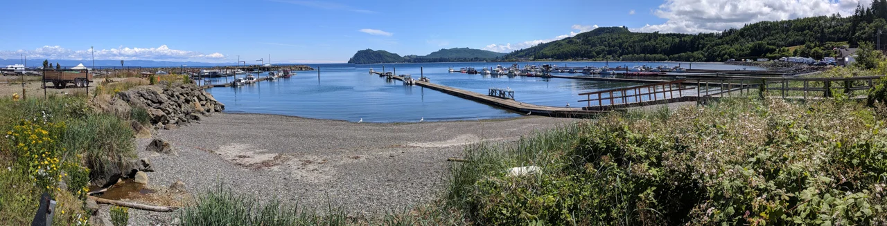

Sekiu, Washington
The 2020 census counted twenty-four people in Sekiu. On a good July morning the boat ramp can move more bodies than that before the coffee has cooled. This is a village that breathes seasonally: a scatter of cabins, docks and motels along the west side of Clallam Bay, looking out across the Strait of Juan de Fuca toward the low blue ridge of Vancouver Island. Across the water on the bay's east shore sits its twin, the community of Clallam Bay. Between them they account for most of what passes for a town along this stretch of Washington's far northwest coast.
A Mark on a Chart
Before Sekiu was a place on land, it was a point on paper. The name first surfaces as "Sekou Pt" on Henry Kellett's chart of 1846, inked by a Royal Navy surveyor mapping a coast he would never live on. Settlement followed three decades later. In 1879 J.A. Martin arrived and set about establishing a salmon cannery here, a reasonable bet on a strait that funnels returning fish straight past the doorstep. Leather tanning came next, and logging after that. Those two industries shaped much of the early Olympic Peninsula economy, and they shaped Sekiu: a working shoreline, a few buildings, and a population that has never needed a second stoplight because it has never needed a first.
What the Strait Provides
The fishing never stopped here. It simply changed hands, moving from canneries and cold storage to charter boats and trailered skiffs. What fills Sekiu now is the water immediately offshore, where salmon, halibut, lingcod and rockfish hold along the ledges with the rest of the bottomfish. Small boats leave in the grey half-light and are back by mid-morning, and the talk on the dock is all depth and tide. Divers work the kelp edges and rock walls. Kayakers trace the shoreline east and west. Birdwatchers come because the strait is a flyway as much as a fishery, a corridor that migrating flocks follow the way the boats follow the fish. And from the Sekiu overlook, without leaving the pavement, you can sometimes watch whales pass offshore.
Ninety-Five Inches
The weather here is less dramatic than the numbers make it sound. Average temperatures run from roughly 41 degrees Fahrenheit in winter to 58 in summer, a narrow band held close by an ocean that refuses to let the thermometer swing. What the ocean does deliver is rain: about 95 inches a year, close to eight feet of water falling annually on a village of two dozen people. Climatologists file this as Cfb under the Koppen system, marine west coast, the same category that covers coastal Ireland and the west of Scotland. In practice it means moss on everything, green that never entirely switches off, fog that arrives without announcing itself, and a short bright summer that residents and visitors alike have learned to use hard.
The Road That Runs Out
Highway 112 is the thread that holds this coast together, and it is not in a hurry. It hugs the strait, climbs over headlands, and drops back to sea level at each bay, delivering drivers to Clallam Bay and then to Sekiu, and then continuing west until the pavement reaches Neah Bay and the territory of the Makah Nation. Beyond that lies Cape Flattery, the northwesternmost point of the contiguous United States, where the continent simply stops. There is a particular quality to towns near the end of a road. Nobody passes through Sekiu on the way to somewhere else. Everyone who arrives has decided to.
The Runway Above the Water
A mile west of the village, Sekiu Airport lays a 2,997-foot lighted runway across a shelf 350 feet above the strait, with a visual approach indicator to help pilots pick it out against the timber. It is owned by the Port of Port Angeles and carries the identifier 11S. For a community of this size, a lighted runway with approach guidance is a remarkable piece of infrastructure, and it says something true about how people actually reach this coast. The highway is beautiful and slow; the air is neither. Pilots come for the same reasons the boats do, which is to say the fish, the quiet, and a shoreline that has not fundamentally changed its outline since Kellett drew it.
From the Air
Sekiu sits at 48.2606 N, 124.303 W on the south shore of the Strait of Juan de Fuca, roughly 15 nautical miles east of Cape Flattery. Best viewing altitude is 2,000 to 3,500 feet AGL, low enough to pick out the twin communities on either side of Clallam Bay and the boat traffic working the kelp lines offshore. Key visual landmarks: the deep notch of Clallam Bay itself, the Strait of Juan de Fuca running east-west with Vancouver Island's shoreline clearly visible 12 to 15 nm across the water, and the dark unbroken forest of the Olympic Peninsula filling the horizon to the south. Sekiu Airport (11S) lies one mile west of the village with a 2,997-foot lighted runway at 350 feet elevation. Nearby fields include William R. Fairchild International at Port Angeles (KCLM) about 45 nm east and Quillayute State (KUIL) near Forks to the south. Expect marine layer, low stratus and fog, particularly in summer mornings; ceilings along this coast can drop quickly, and the terrain rises steeply inland.
Nearby Stories
- Red Creek Fir 8.2 km away
- Quillehuyte County, Washington 9 km away
- MV Diamond Knot 9.2 km away
- The Malahat: Vancouver Island's Cliff-Hanging Highway 15 km away
- Clo-oose 15 km away
- Olympic National Park 19 km away
- SS Pacific (1850) 21 km away
- Juan de Fuca Channel 55 km away