Selja Gorges
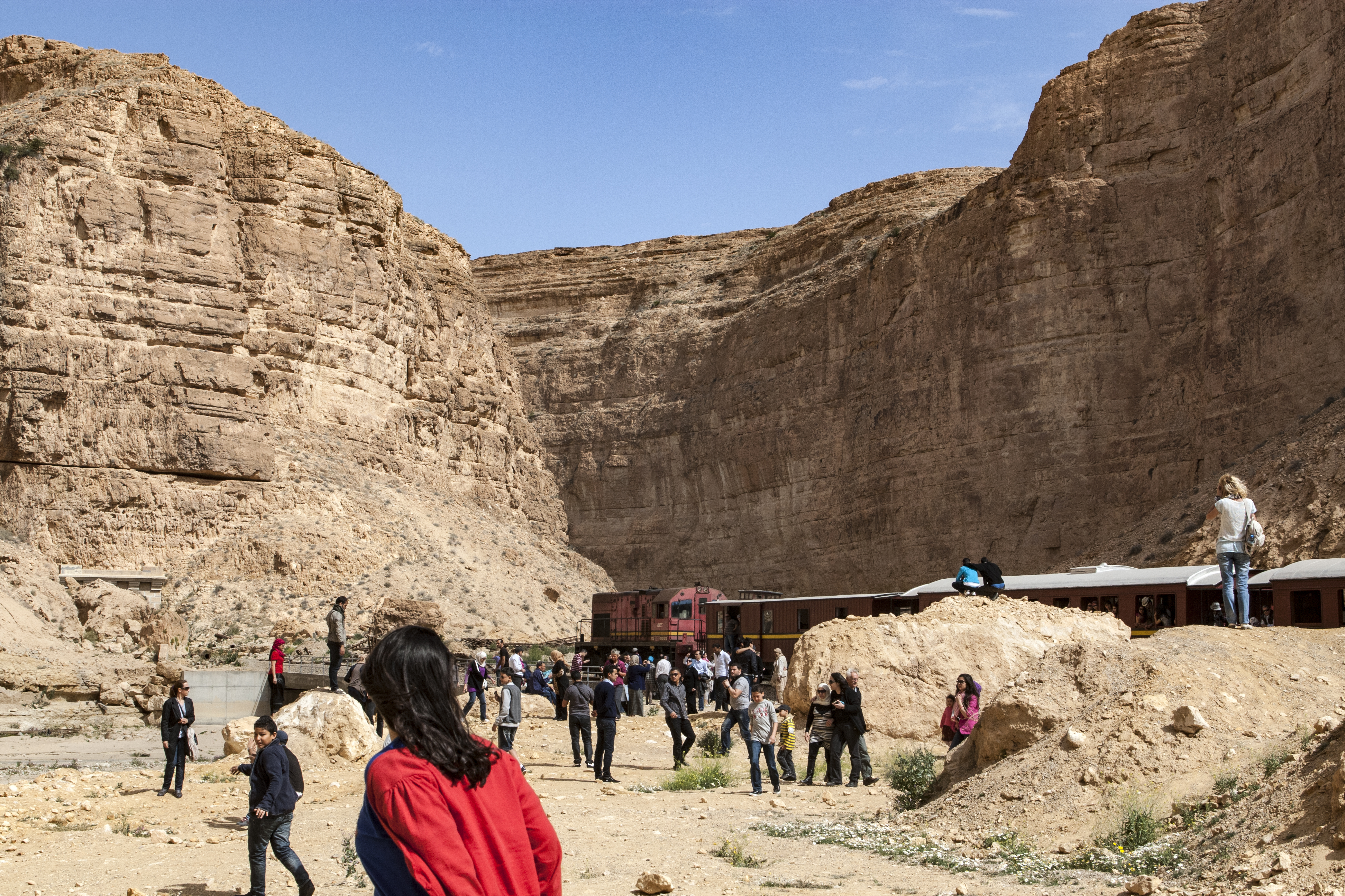
They called it the Red Lizard, and the name was perfect. The refurbished mining train snakes through the Selja Gorges in a sinuous red streak, winding between sandstone walls that glow ochre and crimson under the Tunisian sun. Passengers lean from open windows, cameras clicking at scenery that has no business existing in the arid foothills of the Saharan Atlas. Yet here it is: a lush, improbable ribbon of green cutting through some of the driest terrain in North Africa, where the Thelja Wadi carves its ancient path toward the salt flats of Chott El Gharsa.
A River Through Stone
The Selja Gorges link the Gafsa Valley with the Redeyef plateau in southern Tunisia's Gafsa Governorate, threading several kilometers through deep ravines at altitudes between 210 and 450 meters. The surrounding landscape is mountainous and arid, a fragment of the Saharan Atlas range where rainfall is rare and vegetation clings to survival. But the Thelja Wadi flows year-round, however thinly, sustaining a corridor of life that stands in stark contrast to the parched terrain on either side. An area of 675 hectares has been designated a Ramsar wetland, recognizing its outsized ecological importance. French tamarisks and esparto grass line the banks. Giant canes grow thick where the water pools. Capers flower among the rocks.
Wings and Scales
What makes the gorges remarkable is the wildlife sheltering within them. Endangered golden eagles ride the thermals above the canyon rims, and Eurasian eagle-owls hunt the twilight hours from rocky ledges. Below, the spiny-tailed lizard Uromastyx acanthinura basks on sunbaked stones, its physiology adapted to endure temperatures that would kill most reptiles. The gorges harbor spotted hyenas, the extremely rare Ruppell's sand fox, African wildcats, and the Tunisian tortoise. Desert monitors patrol the rocky terrain while Saharan horned vipers coil beneath overhangs, perfectly camouflaged against the sand-colored stone. Barbary partridges call from the scrub, and European bee-eaters flash iridescent plumage between the cliffs. It is a place where North Africa's biodiversity concentrates in a narrow band, sustained by the persistence of water where water has no obvious right to exist.
Iron Rails Through the Canyon
In 1896, engineers faced a challenge: how to connect the phosphate mines of the Redeyef plateau with the processing facilities at Gabes and the port of Sfax. The answer was to lay track directly through the gorge, an undertaking that demanded numerous tunnels and bridges along its sinuous course. The mining railway transformed the canyon into an industrial corridor, and for more than a century, trains heavy with phosphate ore rumbled through scenery that belonged in a national park. The Red Lizard tourist train eventually repurposed old mining carriages for scenic rides from Metlaoui into the heart of the gorges, giving visitors a view of red buttes and carved rock faces from vintage rolling stock.
The Flood and the Future
In September 2009, massive rains overwhelmed the Redeyef plateau and sent a flood surge roaring through the Selja Gorges. The waters tore up track, swept away wagons, and closed the railway line for a year while crews rebuilt. The episode underscored the gorges' vulnerability: upstream phosphate mining threatens the water quality that sustains the wetland ecosystem, while tourism-related construction encroaches on fragile habitat. A presidential programme launched in 2009 aims to preserve the biotopes and reinforce biodiversity, balancing ecological tourism with scientific research. For now, the golden eagles still circle above the red cliffs, the wadi still trickles through stone, and the Red Lizard still threads its improbable path through a canyon that belongs equally to industry and wilderness.
From the Air
Located at 34.36N, 8.34E in southern Tunisia's Gafsa Governorate. The gorges are visible as a narrow green-brown canyon cutting through arid terrain between the Gafsa Valley and the Redeyef plateau. Best viewed at 3,000-5,000 feet AGL. Nearest airports: Tozeur-Nefta International (DTTZ) approximately 80 km west, Gafsa-Ksar (DTTF) approximately 30 km east. Terrain is mountainous with peaks up to 450 meters. Expect clear, dry conditions most of the year.