Selkirk Lift Bridge
On April 29, 1937, a local man named Ed Maloney decided he had waited long enough. The brand-new vertical-lift bridge spanning the Red River at Selkirk, Manitoba, had been finished for nearly a year, but no level of government would claim ownership -- and without an owner, the bridge sat with its deck raised, barricaded with timbers, useless to the people it was built to serve. So Maloney walked out to the mechanism, cranked the lift span down by hand, and opened the bridge to traffic himself. Federal officials arrived to close it. The community pushed back. Within days, engineers inspected the structure, and on May 3, 1937, the Selkirk Lift Bridge was officially opened at 12:45 p.m. A few excited locals celebrated by cutting a hole in the river ice and jumping in.
Depression-Era Defiance
Before 1934, residents of Selkirk and the neighboring Rural Municipality of St. Clements relied on a busy ferry to cross the Red River. When the Canadian government allocated $40 million to a national infrastructure program to combat Great Depression unemployment, Manitoba received $4 million, and $250,000 was earmarked for a bridge connecting the two communities. Engineer Arthur John Showell Taunton designed the structure: a steel truss bridge measuring 740 feet long by 26 feet wide, with five fixed spans and a central vertical lift span that could rise to let ships pass beneath. Construction ran from 1935 to early 1937. But a bureaucratic absurdity was building alongside the steel. The federal government had funded construction, yet maintenance and upkeep were left to the municipalities. Neither Selkirk, St. Clements, nor the Province of Manitoba wanted the financial burden. The completed bridge sat idle, its span deliberately raised to prevent any crossing.
The Man Who Opened a Bridge
Ed Maloney's solution was beautifully direct. He placed wood planks against the bridge approaches and manually lowered the lift span so pedestrians and vehicles could cross. His unauthorized act of civic engineering forced the issue: Ottawa could no longer ignore a bridge that people were already using. Authorities briefly raised the span again, allowing only pedestrians, but Maloney lowered it once more. The newspapers dubbed the saga the 'War of Selkirk Bridge.' When the official opening finally came on May 3, 1937, it arrived with minimal fanfare -- no ribbon-cutting ceremony, no politicians taking credit. The real celebration had already happened when Maloney turned the crank. The bridge was eventually administered by St. Clements before ownership transferred to the Province of Manitoba in 1967, when it was designated Manitoba Provincial Road 204.
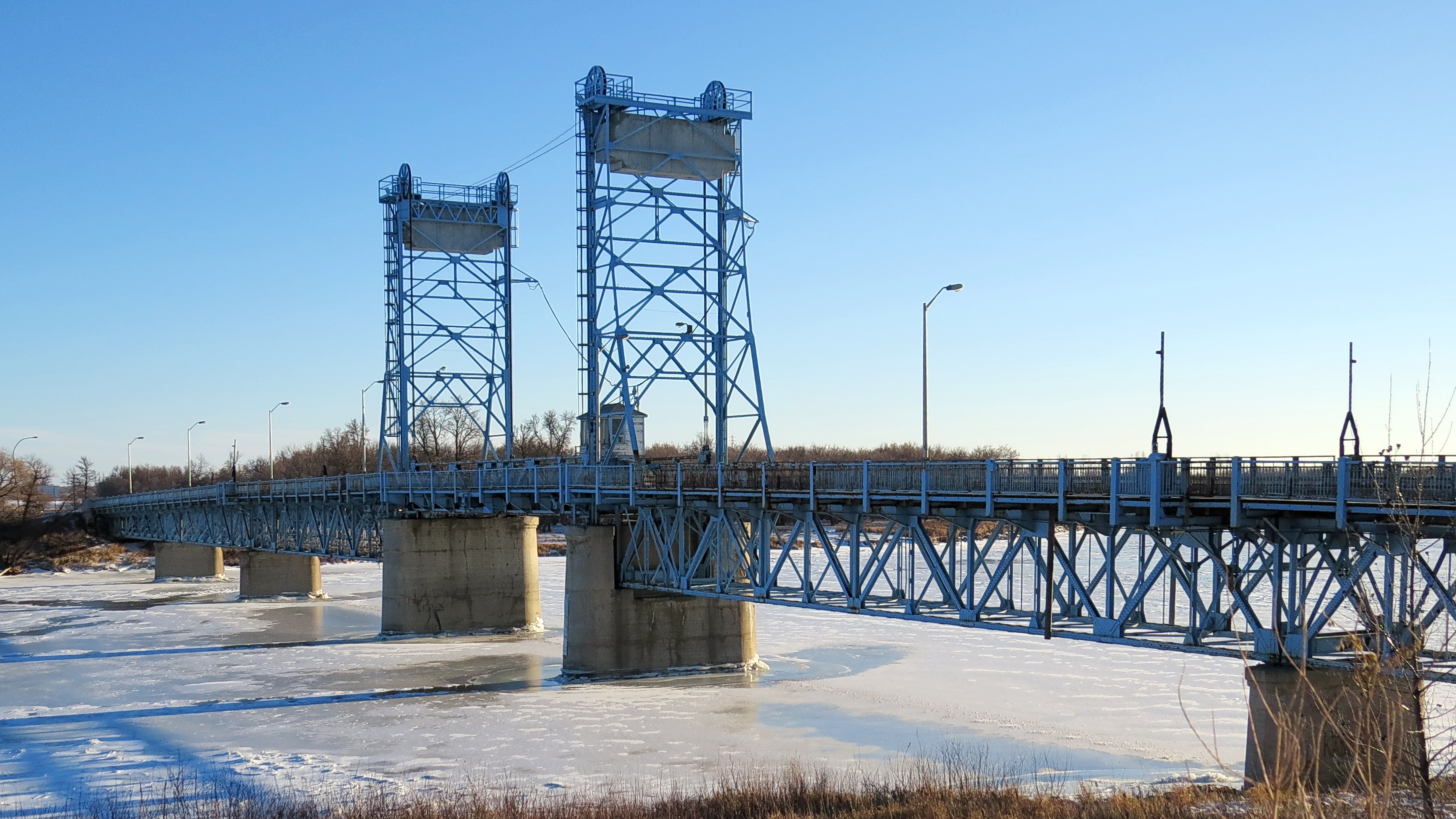
Steel and Water
The Selkirk Lift Bridge is a vertical-lift design, meaning its central span rises straight up between two towers rather than swinging or drawing apart. This allows large vessels -- including the steamships and freight boats that once plied the Red River -- to pass through while the raised deck hangs suspended above the waterway. During the 1938 navigation season, the lift span was raised for boats more than 125 times. The bridge connected Selkirk's main commercial district on the west bank to agricultural land and communities on the east, transforming daily life for residents who had depended on ferry schedules and river conditions. The Red River itself is a defining feature of the region, flowing north through the Manitoba plains toward Lake Winnipeg, prone to dramatic spring flooding that has shaped settlement patterns for centuries.
Weathering the Decades
By the 1970s, decades of Manitoba winters, spring floods, and heavy use had taken their toll. Multiple repair campaigns addressed corrosion and structural wear. In 1990, a Provincial Highways Department official described the bridge's condition as 'disgraceful.' On January 6, 1992, the bridge closed for a $2.8 million rehabilitation -- a sum more than eleven times its original construction cost. It reopened on September 12, 1992. The Selkirk Lift Bridge endures as a working piece of Depression-era infrastructure and a symbol of the community it was built to connect. It has survived floods, bureaucratic neglect, and the slow assault of time and weather. But its most enduring story remains the day Ed Maloney decided that a bridge built for the people should be used by the people, and cranked it open himself.
From the Air
Located at 50.141°N, 96.869°W, the bridge spans the Red River at Selkirk, Manitoba, approximately 35 km north-northeast of downtown Winnipeg. The vertical-lift structure is recognizable from the air by its two steel towers flanking the central lift span, crossing the Red River which flows northward toward Lake Winnipeg. Winnipeg James Armstrong Richardson International Airport (CYWG) is roughly 40 km to the south-southwest. St. Andrews Airport (CKL5) lies approximately 12 km south along the river. Best viewed at 1,500-3,000 feet AGL, where the bridge's steel truss structure and lift towers are clearly visible against the flat prairie landscape. The Red River provides an unmistakable navigation line running north-south through the region.