Seoraksan
Koreans call it the backbone of their country, and the metaphor fits. Seoraksan rises along the Taebaek mountain range on South Korea's eastern flank, its peak Daechongbong reaching 1,708 meters above the coastal city of Sokcho. Only Hallasan on Jeju Island and Jirisan to the south stand taller. But raw height is not what draws more than three million visitors a year. It is the granite -- spires, cliffs, and bizarre formations sculpted by weathering into shapes that have inspired folk legends for centuries. UNESCO designated the mountain a biosphere reserve in 1982, recognizing an ecosystem where Asiatic black bears and mountain goats still roam forests that shift from broadleaf warmth near the coast to subalpine severity on the ridgeline.
Three Faces of a Mountain
Seoraksan divides itself into three distinct zones, each with its own character. Oeseorak, Outer Seorak, faces the East Sea and the city of Sokcho. Its trails are the most accessible, threading past Biryong Falls -- the 'Flying Dragon' waterfall -- and Yukdam Falls within an easy walk of the main car park. This is the zone most visitors know. Naeseorak, Inner Seorak, belongs to the Inje-gun region in the northwest, where Baekdam Valley and the Cheonbul-dong Valley -- the Valley of a Thousand Buddhas -- wind through terrain named for the rock formations lining its sides, which resemble rows of seated Buddhas. Namseorak, South Seorak, completes the triad. Between them, the three zones harbor ecosystems shaped by contrasting climates: the seaward slopes carry a marine influence with steep, exposed rock, while the inland slopes hold thick soil and dense forest.
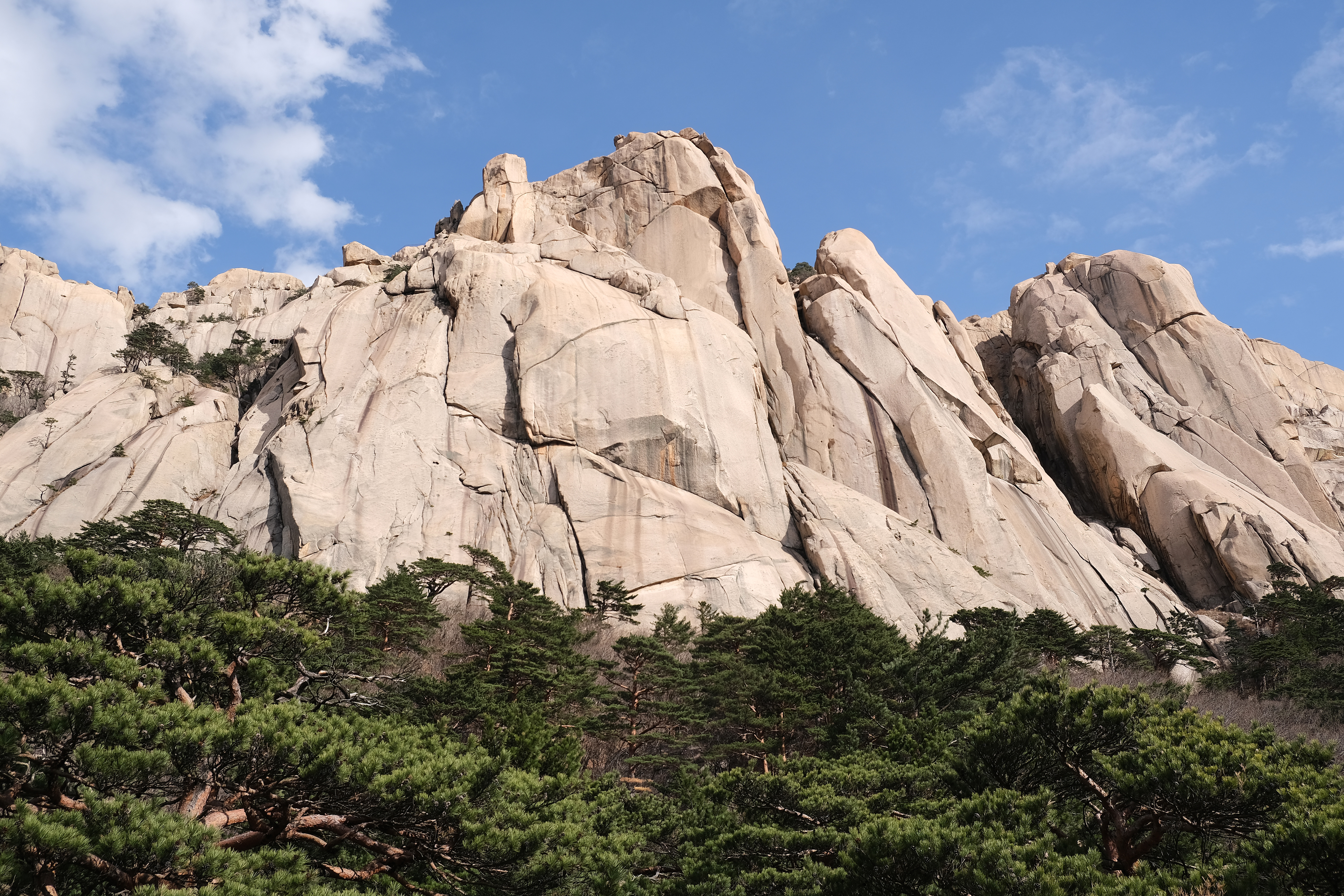
The Rock That Stayed
Ulsanbawi is the mountain's most famous formation -- six granite peaks standing 873 meters above sea level, their sheer cliffs rising 200 meters with a circumference of four kilometers. Reaching them requires climbing 888 steps, but the real attraction is the legend. According to Korean folklore, when the god of mountains was assembling the twelve thousand peaks of Mount Kumgang, he summoned the finest rocks from across the peninsula. A great rock from the southern city of Ulsan set off northward but arrived too late; there was no room. Ashamed to return home, the rock settled in Seorak and never left. Along the path to Ulsanbawi stands Heundeulbawi, a spherical boulder five meters tall perched atop a larger rock. Thousands of visitors have tried to push it off. Nobody has succeeded, though with effort, you can feel it wobble.
Where Dinosaurs Walk the Ridgeline
Running from Madeungyeong pass to Sinseonam, the Dinosaur Ridge earns its name honestly. Its jagged peaks silhouette against the sky like the spiked spine of a stegosaurus. Designated Korea's 103rd scenic treasure in 2013, the ridge is also one of the country's most punishing hikes -- 5.1 kilometers that the park signs estimate at five hours, though a full traverse from the eastern entrance can stretch beyond ten. The approach alone requires a steep climb to the Madeungyeong pass or the Huiwoongak shelter before the exposed ridge even begins. Remote, steep, and demanding scrambling in places, the Dinosaur Ridge has claimed lives. In December 1993, two university students lost their way after dark and died of hypothermia on its slopes. Winter ice and summer rain make the route treacherous, but those who complete it find some of the most dramatic mountain scenery on the Korean Peninsula.
Bronze Buddha and Ancient Temples
Near the main entrance to Seoraksan National Park, the Sinheungsa temple complex announces itself with a 14.6-meter bronze Buddha statue, completed in 1997 after a decade of work. Called the Unification Great Buddha, it was built to embody the hope of Korean reunification -- a potent symbol given that Seoraksan sits just 50 kilometers from the border with North Korea. The temple itself traces its founding to 652 CE, when the monk Jajang established a precursor temple in these mountains. Fire destroyed it in 698. The monk Uisang rebuilt it in 701 under a new name, Seonjeongsa. Through centuries of destruction and renewal, the site has persisted. Surrounding it, smaller hermitages like Gyeongjoam, dating to 655, and Anangyam, established in 1785, dot the forested slopes. At a mountain where the granite endures and the temples keep rebuilding, permanence and impermanence exist side by side.
From the Air
Seoraksan (38.12N, 128.47E) is the dominant peak in the Taebaek range on South Korea's northeast coast, visible from altitude as a rugged granite massif rising to 1,708m. The nearby city of Sokcho lies on the coast. Yangyang International Airport (RKNY) is approximately 30 km to the south. Expect mountain weather with rapid visibility changes. The Dinosaur Ridge and Ulsanbawi formations are distinctive from the air.