Severn Bridge
For 137 years, anyone wanting to drive between England and South Wales at this point had to wait for the Aust Ferry. The crossing was slow, weather-dependent, and frequently congested. When Queen Elizabeth II opened the Severn Bridge on 8 September 1966, she ended an era of frustration and connected two nations with a single sweep of steel and concrete. The bridge cost eight million pounds and took three and a half years to build. Its engineering innovations, particularly its aerodynamically shaped deck, influenced bridge design around the world.
Replacing the Ferry
The Aust Ferry had operated since 1829, carrying vehicles across the Severn Estuary between Aust in Gloucestershire and Beachley in Monmouthshire. By the mid-twentieth century, the service was hopelessly inadequate for growing traffic. Vehicles queued for hours, and high winds or tides regularly suspended operations. Plans for a road bridge had been discussed since the 1930s, but World War II and postwar austerity delayed construction. When work finally began in 1961, the engineering challenge was formidable. The Severn Estuary has one of the highest tidal ranges in the world, its currents are fierce, and the exposed location subjects any structure to powerful winds.
The Bridge That Changed Bridges
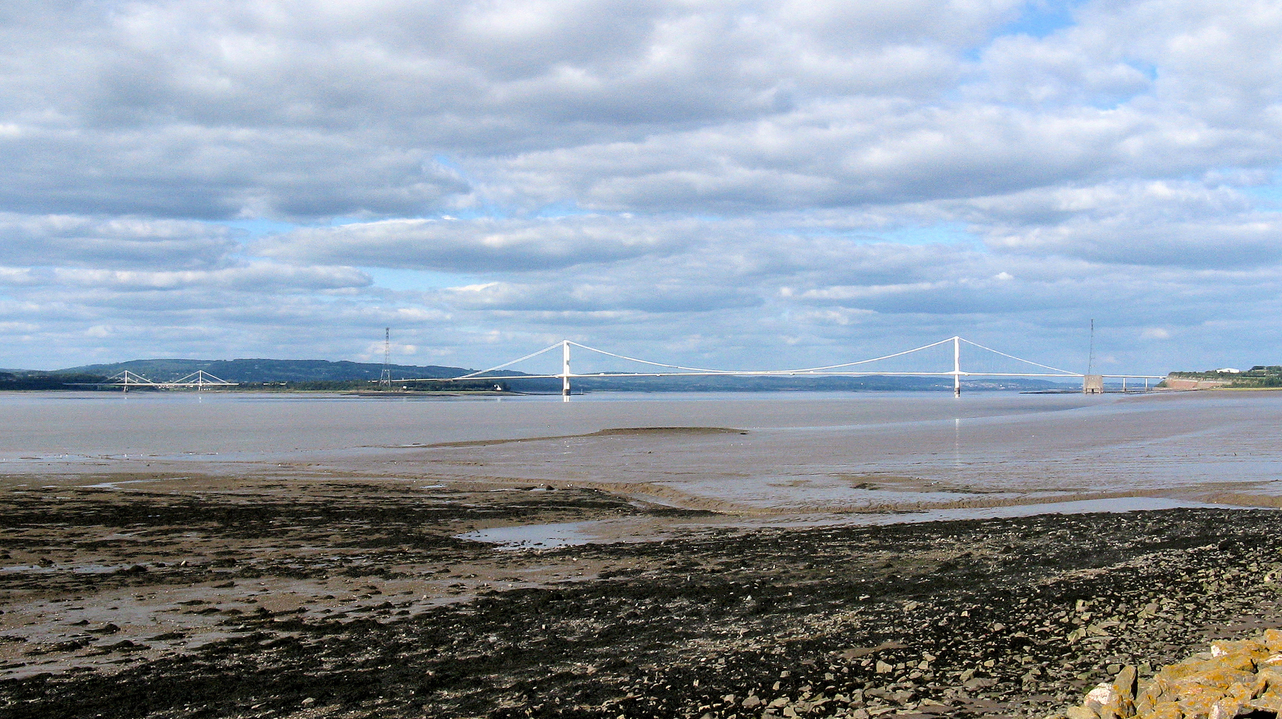
The Severn Bridge's most significant innovation was its deck. Rather than using a conventional deep truss, the designers created a streamlined, aerodynamic box girder only ten feet deep, shaped to slice through wind rather than resist it. This was a direct response to the 1940 collapse of the Tacoma Narrows Bridge in Washington State, which had been destroyed by wind-induced oscillation. The Severn Bridge's slender profile reduced the wind loading on the structure and allowed for a lighter, more elegant design. The approach was so successful that it became the model for long-span suspension bridges worldwide. The main span stretches 3,240 feet between the two towers, with the road deck suspended 100 feet above the water at high tide.
A Toll-Free Crossing
For over fifty years, the Severn Bridge charged tolls, initially to repay the construction costs and later under a concession agreement. When the Second Severn Crossing opened in 1996, the original bridge was redesignated to carry the M48 motorway rather than the M4. Both bridges continued charging tolls until December 2018, when the crossings became free, ending charges that had risen to 6.70 pounds for cars. The removal of tolls transformed the economic relationship between South Wales and southwest England, making commuting and commerce across the border significantly easier. The bridge was granted Grade I listed status in 1999, recognition of its engineering and historical importance.
Two Bridges, One Estuary
The Severn Estuary is now spanned by two crossings. The original 1966 bridge and the Second Severn Crossing, opened thirty years later, carry different motorways and serve complementary traffic flows. From the air, both bridges are dramatically visible, thin lines of engineering spanning the brown tidal waters where the Severn meets the Bristol Channel. The original bridge's graceful suspension cables curve between its towers, while the newer cable-stayed crossing downstream has a more angular geometry. The estuary itself is a landscape of mudflats, sandbanks, and treacherous currents, a reminder of why the ferry crossing lasted as long as it did, and why the bridges that replaced it are regarded as some of the most important transport infrastructure in Britain. The original bridge also hosts a weekly parkrun along its deck, a use that its 1960s engineers could hardly have anticipated.
From the Air
Located at 51.609N, 2.638W, spanning the Severn Estuary between Aust (South Gloucestershire) and Chepstow (Monmouthshire). Both Severn crossings are prominent visual landmarks from the air. Nearest airports: EGGD (Bristol, 12 nm south), EGFF (Cardiff, 25 nm west). The estuary's extreme tidal range creates dramatically different appearances between high and low tide. Recommended viewing altitude 2,000-5,000 ft for both crossings in context.