Seward Park
The parrots arrive without warning. A flash of green and red erupts from the Douglas firs, and suddenly a dozen scarlet-fronted conures are wheeling above Lake Washington, screeching in a language that belongs to the Andes, not the Pacific Northwest. They have lived here since at least 2004, freed or escaped pets who found in Seward Park's old-growth canopy something worth staying for. They are not the only unlikely residents. Two pairs of bald eagles nest in the ancient trees, launching from branches that were already thick when Seattle was still a mudflat logging camp. This 300-acre peninsula, named for the secretary of state who bought Alaska, is a place where the wild and the improbable have always coexisted.
Ten Thousand Years on the Rocky Noses
People have been coming to Bailey Peninsula since the end of the last glacial period, roughly 10,000 years ago. The Duwamish people, specifically a subgroup that gathered resources here, knew the landform by its Lushootseed name, which referred to the rocky points, or "noses," at the north and south tips of the peninsula. The marshy neck of land connecting it to the mainland had its own Lushootseed name meaning just that: "neck." Before the Lake Washington Ship Canal was completed in 1916 and lowered the lake's water level, those rocky noses jutted more dramatically from the shoreline, and the isthmus that tethered the peninsula to the mainland was a soggy, seasonal affair. The landscape people see today is a drained and reshaped version of what the Duwamish knew.
The Olmsted Vision and a $322,000 Bet
Seattle first considered buying Bailey Peninsula in 1892, but the idea stalled. The peninsula felt too remote, too far from the bustling downtown waterfront. It took the Olmsted Brothers, the legendary landscape architecture firm that shaped parks across America, to see the potential. When the Olmsteds drew up their plan for Seattle's park system, they wove Bailey Peninsula into the design. In 1911, the city paid $322,000 for the land and named it after William H. Seward, the secretary of state who negotiated the Alaska Purchase in 1867. Seward never visited the park or the Pacific Northwest, but his name stuck to a place defined by the same quality his most famous deal possessed: audacious vision applied to wild, distant territory.
Gifts Across the Pacific
At the park's entrance, tucked in a wooded island between the circular entrance and exit roads, stands a taiko-gata stone lantern. It was a gift from the City of Yokohama in 1931, given in gratitude for Seattle's aid after the devastating Great Kanto earthquake of 1923. Nearby, a Japanese-style wooden torii once marked the gateway to the park, originally built for Seattle's Potlatch festival in 1934 and moved to the entrance in 1936. Designed by Kichio Allen Arai, the first Asian American architect credited for his work in Seattle, the torii stood for nearly fifty years before decay forced its removal in the mid-1980s. A replacement, built with stone columns and timber cross beams, was completed in early 2021 and formally dedicated in 2022, closing a gap that had lasted nearly four decades.
The Forest That Remembers
Seward Park's old-growth grove is one of the last surviving tracts of ancient forest within Seattle's city limits. The oldest trees here are more than 250 years old, though many are younger, placing the forest's origins well before the founding of the city. By pre-settlement standards this is a young woodland: Seattle's original forests typically reached ages of 1,000 to 2,000 years before logging erased them. A trail bisected by granite markers winds through the interior, and the canopy overhead filters light into green-gold columns. The forest earned a presidential visit on April 22, 2022, when Joe Biden came to Seward Park and signed an executive order directing an inventory of "mature and old-growth trees" across the nation for conservation purposes.
Perimeter Loop and Panoramas
The most popular route in the park is the flat, car-free perimeter trail that loops around the peninsula. Repaved in 2007, the path draws walkers, runners, cyclists, and rollerbladers past small beaches and viewpoints that open onto Mount Rainier to the southeast, Mercer Island across the lake, and the ridgeline of Leschi and Mount Baker to the north. The largest beach sits on the southwest side, at Andrews Bay, flanked by a broad lawn. Above it, the park's Tudor-style inn, a designated Seattle city landmark originally called the Seward Park Inn, was renovated in 2008 and now houses the Seward Park Audubon Center. The center runs school and youth programs, environmental education, and community events, and its library, laboratory, and exhibits anchor the park's identity as a place where urban life meets genuine wilderness.
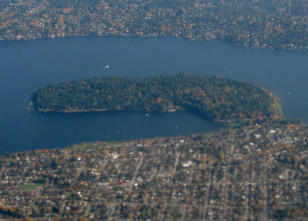
From the Air
Seward Park occupies Bailey Peninsula at 47.555N, 122.250W, jutting westward into Lake Washington from Seattle's southeast side. From the air, the dense forest canopy contrasts sharply with the surrounding residential neighborhoods, making the peninsula easy to spot. Look for the oval-shaped landmass connected to the mainland by a narrow isthmus. Andrews Bay lies to the southwest. Mount Rainier is visible to the southeast on clear days. Nearest airports: Boeing Field/King County International (KBFI) 4nm west-northwest, Renton Municipal (KRNT) 4nm south, Seattle-Tacoma International (KSEA) 10nm south-southwest.