Shomyo Falls
The sound reaches you before the sight does. Walking the forest path toward the cliff face in Tateyama, Toyama Prefecture, a low rumble builds through the trees -- not thunder, not machinery, but water falling 350 meters in a single unbroken cascade. The people who named this place heard something sacred in that sound. Shomyo is the Japanese word for Buddhist liturgical chanting, and the falls earned their name because the deep, resonant roar of water striking rock after a 1,148-foot descent reminded listeners of monks intoning sutras in a vast stone temple. It is Japan's tallest waterfall, and standing at its base, the comparison feels less poetic than literal.
Four Stages of Descent
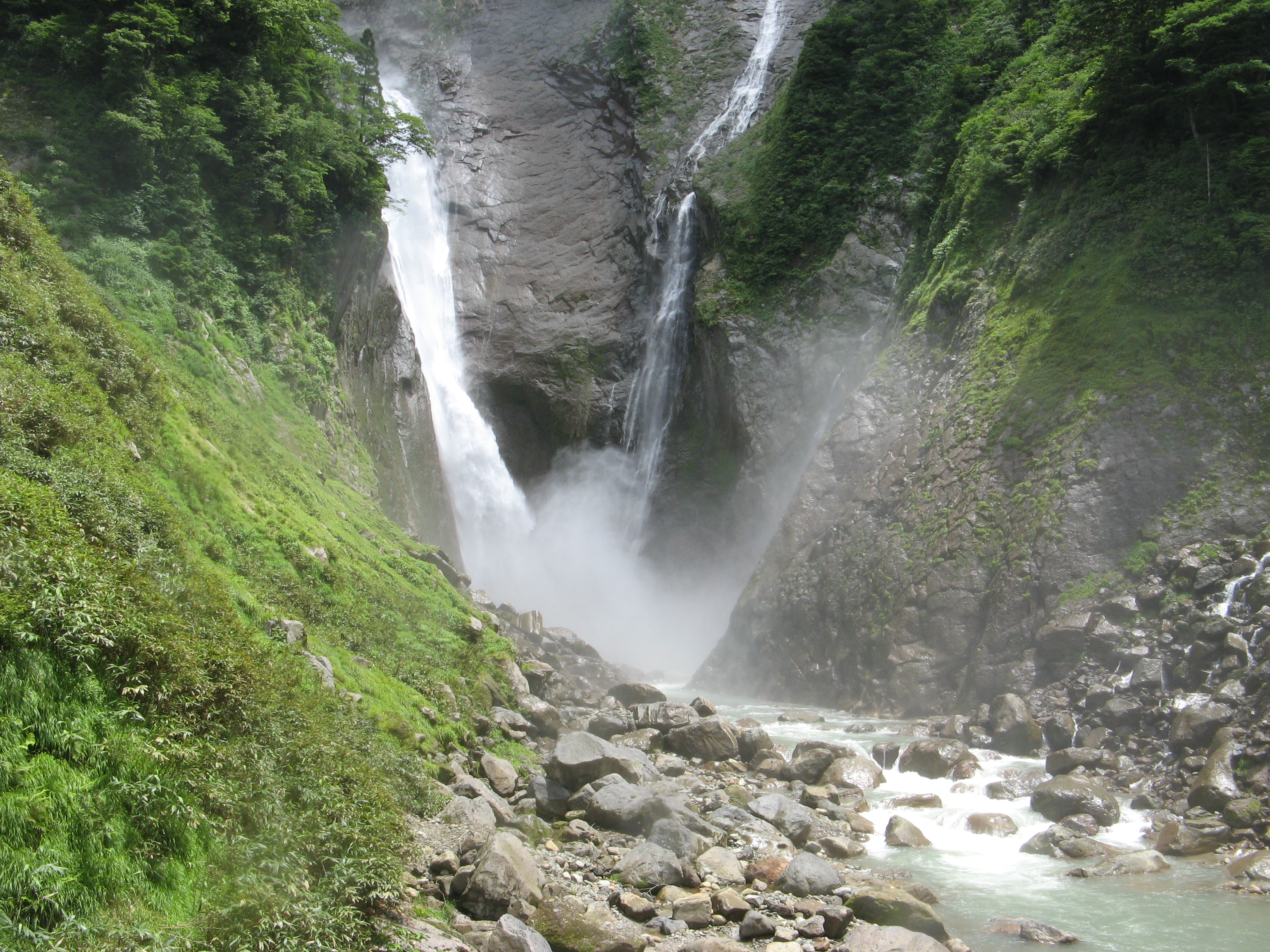
Shomyo Falls does not simply drop. It descends in four distinct stages, each with its own character. The first stage plunges 70 meters off the upper cliff, a clean vertical sheet of white. The second falls 58 meters over a slightly angled face. The third -- the longest single drop at 96 meters -- is where the water accelerates into a roaring curtain, spray billowing outward in the mountain wind. The final stage, 126 meters, delivers the cascade into the pool below with enough force to shake the observation platform. The total drop of 350 meters has earned Shomyo Falls designation as a National Scenic Spot and Natural Monument, and its thundering voice was selected as one of Japan's 100 best soundscapes.
The Ghost Twin
For most of the year, Shomyo Falls stands alone on its cliff face. But from April to July, when the snowpack on the Midagahara plateau above begins its annual melt, a second waterfall materializes beside it. Hannoki Falls appears as if summoned, a seasonal twin cascading 497 meters down an adjacent rock face -- taller than Shomyo itself, and technically Japan's highest waterfall during the brief months it exists. The two falls face each other almost like mirror images, separated by a narrow rock ridge, their combined spray creating a perpetual mist that rainbows pass through on sunny mornings. By midsummer, as the snow supply exhausts itself, Hannoki thins to a trickle, then vanishes entirely, leaving Shomyo to reign alone until the next spring thaw.
A Landscape Shaped by Snow
The volume of water pouring over Shomyo Falls varies dramatically with the seasons, and the falls are at their most powerful in early to mid-summer when the deep snowfields of the Tateyama Mountains release their stored water. This is the same snow that creates the famous Yukino-otani snow walls along the Tateyama Kurobe Alpine Route nearby, where plowed corridors cut through drifts that can tower 20 meters high. Shomyo Falls is visible across the valley while traveling the road from Tateyama Station to Murodo Plateau, a fleeting glimpse of white against dark volcanic rock that hints at the scale only apparent up close. The trail to the falls takes about 30 minutes on foot and is free to walk, though the road and path close from late November through spring under heavy snow -- the same snow that will, months later, feed the cascade all over again.
Listening to the Mountain
Shomyo Falls exists within a landscape deeply shaped by religious tradition. Mount Tate, the peak that anchors the Tateyama range above the falls, is one of Japan's three sacred mountains, a site of mountain ascetic worship for over a thousand years. The name Shomyo itself bridges the natural and the spiritual -- a reminder that in the Japanese aesthetic tradition, the boundary between the two has always been thin. Visiting the falls is a sensory experience that goes beyond the visual. The air near the base is thick with mist, cold even in summer. The sound oscillates between a steady roar and something almost musical, particularly when wind shifts the curtain of water against the rock face. The observation platform provides a direct view up the four stages, the uppermost stage dissolving into clouds on overcast days. It is the kind of place where standing still for a few minutes feels more rewarding than any photograph.
From the Air
Located at 36.575N, 137.523E in the Tateyama Mountains of Toyama Prefecture, Japan. The falls face roughly east on a steep cliff face within a deep valley. Best viewed from the east at altitudes of 5,000-8,000 feet, though the narrow valley and surrounding peaks (Mount Tate rises to 3,015 meters / 9,892 feet) demand caution and awareness of mountain weather. The seasonal Hannoki Falls will be visible alongside Shomyo from April to July. Nearest airport: Toyama Airport (RJNT), approximately 25nm east-northeast. The Tateyama Kurobe Alpine Route and Kurobe Dam are visible nearby to the south and east. Expect orographic cloud formation and turbulence near the ridgeline, particularly in afternoon thermal conditions.