Shan State
In the Shan language, they call it Muang Dai -- "our country" -- and the possessive is deliberate. For centuries, this highland plateau straddling the borders of Myanmar, China, Laos, and Thailand has belonged less to any central government than to the dozens of ethnic groups who farm its terraced hillsides, fish its lakes, and occasionally fight over its future. Covering 155,800 square kilometers, nearly a quarter of Myanmar's total land area, Shan State is the country's largest administrative division. It is also, in many ways, its most ungovernable. East of the Salween River, entire districts operate on Chinese Standard Time and trade in yuan. Elsewhere, ceasefire agreements hold together a fragile peace between ethnic armies and the central military. And yet amid this complexity, Shan State contains some of Southeast Asia's most extraordinary landscapes and cultures.
A Plateau of Kingdoms
The Shan Plateau rises like a rumpled tablecloth above the central Myanmar lowlands, its surface cut by the deep gorge of the Salween River and studded with hills that reach into the clouds. The Tai people who give the state its name arrived with the Mongol armies after the fall of the Pagan Kingdom in 1287, staying to establish a constellation of princely states from the Kachin Hills to the Thai border. The most powerful -- Mohnyin, Mogaung, Hsenwi, and Hsipaw -- competed for dominance in a shifting mosaic of alliances and betrayals. A Mohnyin-led confederation conquered the Ava Kingdom in 1527, but within decades King Bayinnaung reversed the equation, subjugating all the Shan states by 1557. He permitted the Saophas, the hereditary Shan rulers, to keep their regalia and feudal rights, but required their sons to live as hostages in his court. This arrangement, in various forms, persisted for more than three centuries.
Contested Ground
Shan State's modern borders were drawn at the Panglong Conference of February 1947, where Shan leaders negotiated a unified state within an independent Burma -- crucially securing the right of secession after ten years. That promise was never honored. Instead, the state became a theater of Cold War proxy conflict when Chinese Nationalist KMT forces, driven from the mainland, invaded in 1950 and nearly captured the capital Taunggyi in 1953. The opium trade financed their operations and those of the warlords who followed, establishing Shan State as one vertex of the infamous Golden Triangle. According to the United Nations, the state still produced 82 percent of Myanmar's opium in 2020 -- 331 metric tons -- though cultivation has declined each year since 2015. Today the drug economy has shifted toward methamphetamine, much of it manufactured in labs along the Chinese and Thai borders.
Inle's Floating World
At the heart of southern Shan State lies Inle Lake, a shallow expanse of water stretching 14 miles long and 7 miles wide. The Intha people who inhabit its floating villages are famous for a technique found nowhere else: rowing their longboats by wrapping one leg around a single oar, leaving both hands free to manage fishing nets. Their gardens float too -- built on mats of water hyacinth anchored to the lake bed with bamboo poles, producing tomatoes and flowers that supply markets across the region. Nearby, the Pindaya Caves shelter over 8,000 Buddha images accumulated over centuries in vast limestone chambers. Itinerant markets rotate through the surrounding towns on a five-day cycle, setting up in a different village each day, a tradition older than any government that has tried to administer this land.
Where Borders Blur
Shan State's identity has always been defined by proximity. It borders China's Yunnan province to the north, Laos to the east, and Thailand's Chiang Rai, Chiang Mai, and Mae Hong Son provinces to the south. At Muse, the largest border trading center on the Myanmar-China frontier, commerce flows in both directions despite political tensions. At Tachileik on the Thai border, another economy hums. Between them, hundreds of thousands of Chinese immigrants have settled in upper Burma since the 1990s, funding hydropower dams, rubber plantations, and mining operations. The Wa and Kokang regions in the northeast function as virtual Chinese enclaves. The state is home to Chin, Kachin, Wa, Ta'ang, Lisu, Lahu, Pa O, and Kayah communities alongside the Shan majority -- a demographic complexity that no single constitution has managed to resolve.
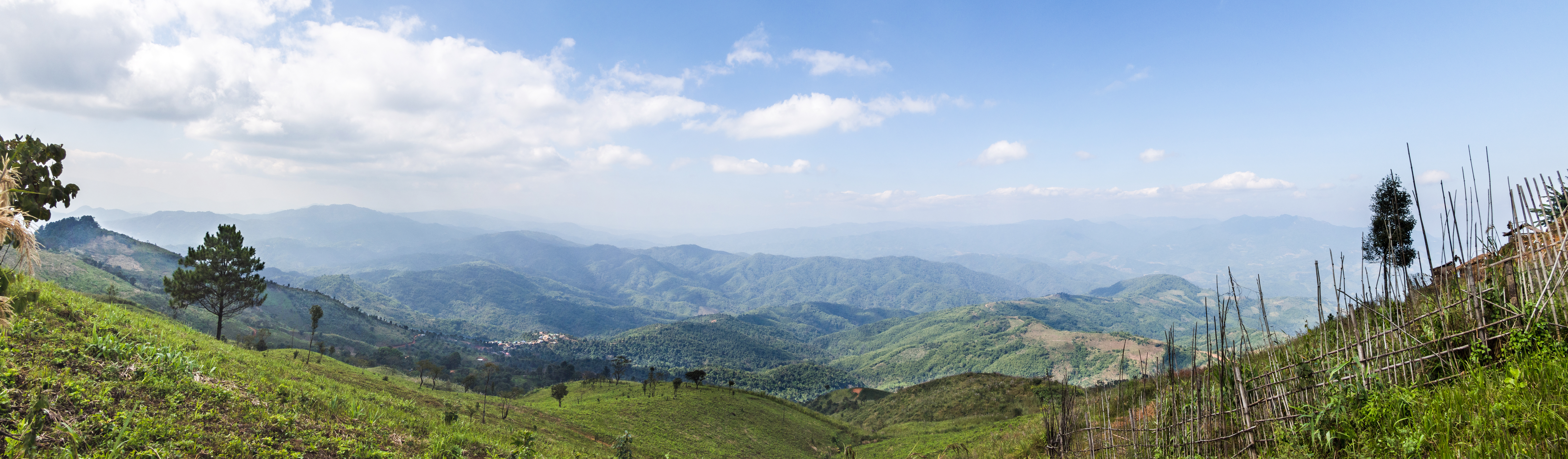
The View from Above
From the air, Shan State reveals its contradictions. The orderly green geometry of rice paddies gives way to rough mountain terrain scarred by logging roads and dotted with the gold spires of Buddhist monasteries. The Salween carves its ancient path through the plateau, and Inle Lake shimmers in its broad valley like a mirror dropped among the hills. The capital Taunggyi, 150 kilometers northeast of the national capital Naypyidaw, huddles against a ridge at the plateau's western edge. Nearby Heho Airport serves as the gateway for the tourists who come for the lake, the caves, and the Kekku Pagodas. But most of the state remains difficult to reach and harder to understand -- a place where 81 percent of the population is Buddhist, only 8 percent of primary school students reach high school, and the boundaries between nation-states matter less than the older loyalties of language, clan, and highland geography.
From the Air
Centered at approximately 21.50N, 98.00E, Shan State covers a vast highland area in eastern Myanmar. Heho Airport (VYHH) near Inle Lake is the primary gateway. Lashio Airport (VYLS) serves the north, while Kengtung Airport (VYKG) and Tachileik Airport (VYTL) cover the east. The Shan Plateau averages 900-1,200 meters elevation with peaks exceeding 2,500 meters. The Salween River gorge is a dramatic visual landmark cutting north-south through the state. Inle Lake is visible as a bright reflective surface in the Nyaung Shwe valley. Best viewed at 15,000-25,000 feet to appreciate the plateau's scale and the contrast between cultivated valleys and forested hills.