Shandong Peninsula
Twenty-seven million years ago, the Shandong Peninsula was still connected to the Korean Peninsula and the Liaodong Peninsula to the north. Then the land split, the Yellow Sea filled the gap, and Shandong became what it is today: a massive arm of land extending eastward between the Bohai Sea and the Yellow Sea, 290 kilometers long and up to 190 kilometers wide. It is the largest peninsula in China, covering 73,000 square kilometers, and its three major cities -- Qingdao, Yantai, and Weihai -- face outward toward Korea and Japan with an openness that geography imposed long before diplomacy arrived.
Seven Thousand Years of Settlement
The Shandong Peninsula was forested in the Paleolithic era. By the Neolithic period, around 7,000 years ago, the Dongyi people had established themselves across the region, building their own kingdom called the State of Lai. When the State of Qi absorbed the peninsula, its rulers constructed the Great Wall of Qi, sections of which still cross the peninsula's interior. During the Han dynasty, the region operated as the semi-independent Jiaodong Kingdom, and its agricultural output earned it the title "granary of the East." The peninsula's hilly terrain and mild, maritime climate proved ideal for fruit cultivation -- a tradition that persists today in Qixia apples, Laiyang pears, and Laoshan honey peaches.
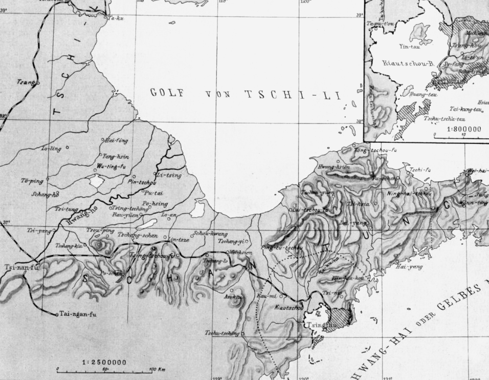
Carved Up by Foreign Powers
The late 19th century brought a cascade of foreign interventions. During the First Sino-Japanese War, Japan captured the naval base at Weihaiwei after a 23-day siege in 1895. Three years later, the German Empire annexed the Kiautschou Bay territory, transforming the fishing village of Qingdao into a major seaport with a brewery that still bears the Tsingtao name. Britain seized Weihaiwei in July 1898. When World War I erupted, Japan took the German territory and held it until the Treaty of Versailles in 1919 transferred Qingdao not back to China but to the Empire of Japan -- a betrayal that ignited the May Fourth Movement, one of modern China's most consequential political upheavals. Shandong was not returned to Chinese control until 1922, following pressure at the Washington Naval Conference.
A Bridge Across the Yellow Sea
Geography has always pulled the Shandong Peninsula toward its maritime neighbors. Historically, waves of migration carried people from Shandong to northeast China by boat, a demographic current that reversed in recent decades as northeastern Chinese "return" to the peninsula. After China established diplomatic relations with South Korea in 1992, Korean investment poured in. More than 200,000 Koreans now live on the Shandong Peninsula, and South Korea maintains a consulate-general in Qingdao. The Jiaoliao Mandarin dialect, native to the peninsula, spread across the Yellow Sea to the Liaodong Peninsula and parts of Manchuria through centuries of migration -- a linguistic footprint of the human traffic that has always flowed through these waters.
Orchards, Factories, and the Sea
The peninsula's economy has roots that reach back to the 8th century BC, when fishing and salt production first emerged during the Spring and Autumn period. Iron smelting and silk-hemp textile production flourished during the Warring States period. By the Tang dynasty, the ports of Dengzhou and Laizhou were handling international trade. Today, Qingdao and Yantai anchor economic development zones that blend manufacturing, technology, and maritime commerce. The surrounding waters teem with aquatic products, and the hills produce the fruits that have defined Shandong agriculture for centuries. Surrounded by sea on three sides, the peninsula's monsoon climate delivers four distinct seasons, with maritime influence softening both the summer heat and the winter cold.
From the Air
The Shandong Peninsula extends eastward at approximately 37.00N, 121.00E, clearly visible from cruising altitude as a large landmass between the Bohai Sea to the north and the Yellow Sea to the south. Key airports include Qingdao Jiaodong International (ZSQD) on the southwestern coast, Yantai Penglai International (ZSYT) on the northern coast, and Weihai Dashuibo (ZSWH) at the eastern tip. The Bohai Strait between Shandong and the Liaodong Peninsula is a prominent navigational feature.