Shasta Dam
When the final bucket of concrete was poured on January 2, 1945, chief engineer Frank Crowe made a bold prophecy: "That dam will stand there forever holding back the river. And that powerhouse will keep right on turning out juice until somebody discovers how to make power out of sunlight." The irony would take decades to unfold. But on that winter morning in Northern California, Shasta Dam stood as a monument to both human ambition and human cost. The second-tallest dam in America had risen from a canyon where three rivers met, built by thousands of workers who escaped the Great Depression only to find themselves laboring on what would become both California's lifeline and the grave of an ancient homeland.
Born from Crisis
The story of Shasta Dam begins not in the mountains of Northern California, but in the salt-poisoned farmlands of the Sacramento-San Joaquin Delta. By the early 1900s, intensive farming had drawn so much water from the Sacramento River that saltwater from San Francisco Bay began creeping upstream. Between 1919 and 1924, teredo worms, those saltwater wood-borers, destroyed piers and ships throughout Suisun Bay. Something had to change. In 1919, Robert Marshall of the U.S. Geological Survey proposed an audacious solution: dam the Sacramento River near its confluence with the Pit River, hundreds of miles north of the Delta, and release stored water during dry months to push the saltwater back. The state tried to fund it alone, but the Great Depression killed the bond sales. When unemployment in California hit 20 percent, President Franklin Roosevelt saw an opportunity. In 1935, he authorized the Central Valley Project as part of the New Deal, and the Bureau of Reclamation brought in Frank Crowe, the man who had built Hoover Dam, to run the show.
A Mountain of Concrete
Construction began in earnest in 1937, transforming a remote canyon into a hive of industrial activity. Pacific Constructors Inc. built the largest conveyor belt system in the world to feed sand and gravel to the mixing plant, a mechanical serpent with 16,000 rollers stretching for miles through the mountains. A steel cable tower rose 465 feet above the river, suspending buckets that carried 16 tons of concrete each, swinging back and forth like industrial pendulums. Workers poured the dam in massive blocks, vibrating each pour to eliminate air bubbles, then sandblasting the cured surface smooth. The labor was grueling, but in the depths of the Depression, men came from across California hoping to find work. Three makeshift camps, named Central Valley, Project City, and Summit City, filled with the unemployed. Then came Pearl Harbor. Thousands enlisted, and the workforce shifted. Women and high school students took over non-hazardous jobs. The dam's generators, initially slated for Shasta, were redirected to Grand Coulee Dam to power aluminum smelters for the war effort. Strained supplies forced engineers to cut the final height from what was originally planned.
The Waters Rise
In February 1944, workers sealed the diversion tunnel and water began pooling behind the massive concrete wall. By the time the last concrete was poured in early 1945, Shasta Lake was already forming. When completed, the dam stood second only to Hoover in height and contained more concrete than any structure in California. Its five steel penstocks, each large enough to drive a truck through, fed water to turbines generating 379 megawatts of power. The reservoir behind it became California's largest man-made lake, capable of storing enough water to supply millions of people and irrigate the agricultural heartland of the Central Valley. An anonymous workman captured the moment with dry humor: "Old Shasta's about the secondest dam there is." But what the rising waters concealed would haunt the dam's legacy for generations.
The Drowned Homeland
Beneath Shasta Lake lie the ancestral lands of the Winnemem Wintu, one of nine groups of the larger Wintu people of Northern California. Before European contact, an estimated 14,000 Wintu lived in these valleys. By 1900, disease and displacement had reduced their numbers to 395. Many of the surviving men enlisted to fight in World War II. When they returned in 1945, they found their families driven from villages now submerged under hundreds of feet of water. More than 90 percent of Winnemem Wintu land was lost. Over 27 sacred sites, village grounds, and burial places now rest beneath the reservoir's surface. In May 1941, Congress had passed the Central Valley Project Indian Lands Acquisition Act, legally seizing Winnemem Wintu homes. Treaties from the 1850s were broken. The tribe remains unrecognized by the federal government. In September 2004, when officials proposed raising the dam even higher to increase water storage, the Winnemem Wintu held a war dance for the first time in 117 years. The proposal would drown 20 more sacred sites, including Children's Rock and Puberty Rock, still used in coming-of-age ceremonies.
River of Consequences
The ecological cost of Shasta Dam extends far beyond submerged lands. The massive concrete barrier completely blocks salmon from reaching the upper Sacramento, Pit, and McCloud Rivers, cutting off an estimated half of the best salmon habitat in the entire Sacramento basin. Warmer water released from the reservoir's sun-heated upper layers proved deadly for cold-water fish. In 1991, engineers installed a Temperature Control Device on the dam's rear face, a structure with 15 shutters at different depths allowing operators to draw colder water from below. It helped, but it couldn't restore what was lost. The dam also starved the downstream river of sediment, nearly all of which was dredged for the dam's concrete. Today, Shasta Dam remains essential to California's water supply, generating peaking power and controlling floods that once devastated the valley. Proposals to raise it persist, pitting farmers desperate for water against tribes fighting to preserve what remains of their heritage. The dam stands as a monument to both achievement and loss, a concrete colossus holding back waters that hold their own secrets.
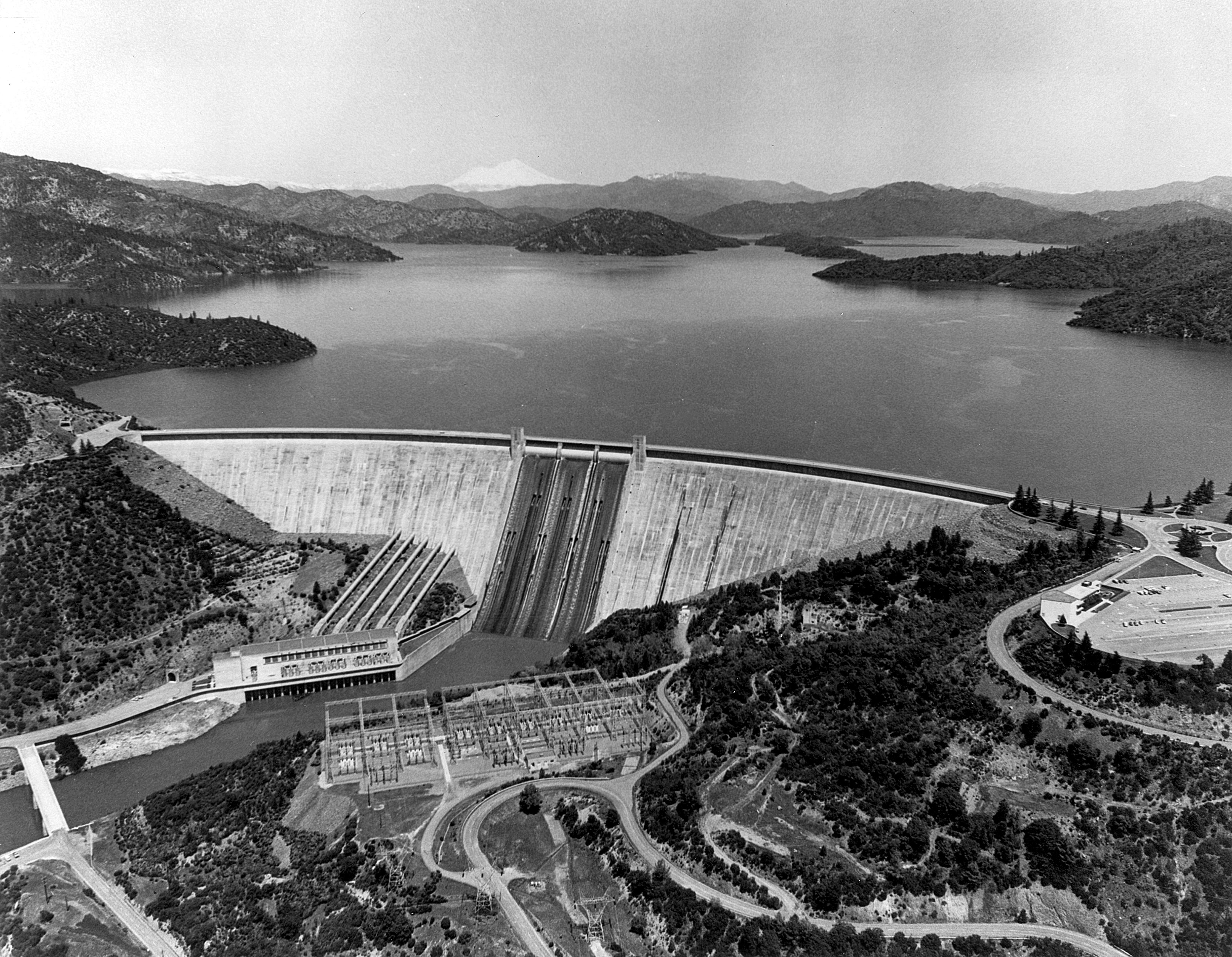
From the Air
Shasta Dam sits at coordinates 40.72N, 122.42W at the north end of the Sacramento Valley. From above, the massive concrete arch-gravity structure spans a canyon where the Sacramento River once flowed free, with Shasta Lake extending north in multiple arms following drowned river valleys. Mount Shasta rises to the north. Best viewed from 5,000-8,000 feet AGL. Nearest major airport is Redding Municipal (KRDD), approximately 10 miles south. The dam's spillway and powerhouse are visible on the downstream face. Clear weather recommended for best visibility of the lake's distinctive shape.