Shikoku Pilgrimage
You can recognize them by the white. Walking pilgrims on Shikoku -- henro, as the Japanese call them -- wear white shirts, carry wooden staffs called kongō-zue, and shade themselves under conical sedge hats. They walk a circuit of 88 Buddhist temples spread across the island, a route of roughly 1,200 kilometers that traces the footsteps of Kukai, the ninth-century monk who founded Shingon Buddhism. Some complete the journey in 30 to 60 days on foot. Others drive between temples or take tour buses. A few ride bicycles. But the white clothing is constant -- a visual thread connecting modern pilgrims to a tradition that has shaped this island for over a thousand years.
The Monk Who Made the Path
Kukai was born at Zentsu-ji, now Temple 75 on the circuit, in the year 774. He studied esoteric Buddhism in China and returned to establish the Shingon school, founding its headquarters on Mount Koya in present-day Wakayama Prefecture. During visits to the island of his birth, he is said to have established or visited many of its temples and to have carved many of their sacred images. Posthumously known as Kobo Daishi, he became the spiritual center around which the pilgrimage crystallized. Whether he personally walked the route that bears his name is less important than the belief that he did. Pilgrims are said to walk with Kobo Daishi -- the phrase "dogyo ninin," meaning "two traveling together," appears on their hats and staffs, a reminder that they are never alone on the path.
Four Provinces, Four Stages
Shikoku means "four provinces" -- the old domains of Awa, Tosa, Iyo, and Sanuki, reorganized during the Meiji period into the modern prefectures of Tokushima, Kochi, Ehime, and Kagawa. The pilgrimage maps these geographic divisions onto a spiritual framework. Temples 1 through 23, in Tokushima, represent awakening. Temples 24 through 39, along Kochi's rugged Pacific coast, embody austerity and discipline. Temples 40 through 65, in Ehime, signify the attainment of enlightenment. The final stretch, temples 66 through 88 in Kagawa, represents entry into nirvana. The framework is symbolic rather than rigid -- pilgrims are not required to visit the temples in order, and some walk the circuit in reverse, a practice with its own tradition.
The Kindness of Strangers
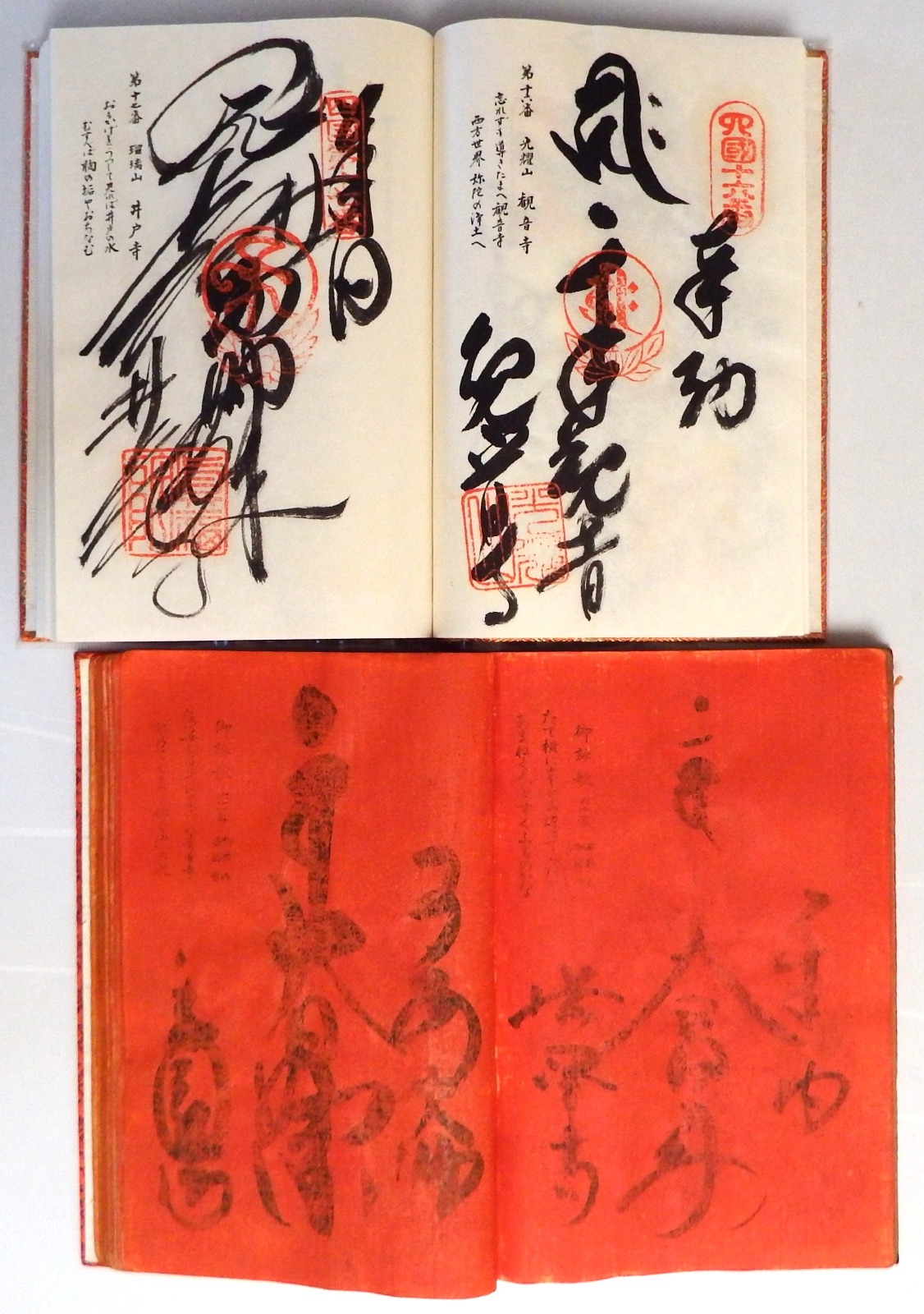
One of the pilgrimage's most distinctive features is osettai -- the practice of local residents offering alms to passing pilgrims. Food, drinks, shelter, sometimes money: the gifts vary, but the spirit is consistent. Osettai reflects a belief that supporting a pilgrim generates merit for the giver as well. Along the route, henro are addressed with a respectful form by locals who understand themselves as participants in the journey, not merely bystanders. At each temple, the ritual is specific: the pilgrim washes, proceeds to the main hall, offers coins and incense, chants the Heart Sutra, and repeats the mantra of the temple's principal image. Then comes the visit to the shrine of Kobo Daishi, where the Heart Sutra is chanted again. The stamp book fills, temple by temple, into a record of passage and devotion.
Walking into the Modern World
The pilgrimage has adapted to every era. During the Edo period, when movement was restricted and regulated, pilgrims needed travel permits and had to follow designated paths within set time limits. The stamp book served double duty as proof of legitimate travel. In the eighteenth century, the pilgrimage's popularity inspired smaller imitative versions: a 3-kilometer course at Ninna-ji in Kyoto, a route on the Chita Peninsula near Nagoya, circuits in Edo and Chiba Prefecture. Today, many pilgrims complete the journey by visiting Mount Koya in Wakayama Prefecture, returning to the headquarters of Shingon Buddhism that Kukai established. The 21-kilometer walking trail up to Koya-san still exists, though most pilgrims now take the train. At Temple 88, pilgrims can purchase a completion certificate whose name translates simply as "fulfillment of one's wishes."
From the Air
The Shikoku Pilgrimage circles the entire island of Shikoku, Japan's fourth-largest island, located at approximately 34.16N, 134.50E. The 88 temples are distributed across all four prefectures: Tokushima (east), Kochi (south), Ehime (west), and Kagawa (north). Major airports on the island include Tokushima (RJOS), Kochi (RJOK), Matsuyama (RJOM), and Takamatsu (RJOT). From altitude, the island's mountainous interior and coastal roads that the pilgrimage follows are visible. The route spans roughly 1,200 km around the island's perimeter. Recommended viewing altitude: 10,000-15,000 feet for full island context.