Shinjuku: Tokyo's Restless Second Center
The name means "new station." In 1698, a relay stop called Naito-Shinjuku appeared on the Koshu Kaido highway, named for the local daimyo lord whose estate would later become Shinjuku Gyoen, one of Tokyo's most beloved parks. For two centuries, this was the edge of the capital -- a traveler's waypoint, not a destination. Then the 1923 Great Kanto Earthquake flattened neighborhoods across central Tokyo but largely spared the seismically stable Yodobashi Plateau beneath Shinjuku. Businesses fled the rubble and rebuilt here. That geological accident -- solid ground where the rest of Tokyo shook -- turned a relay station into a metropolis within a metropolis, a rival to the old Marunouchi center that now houses the world's busiest railway station and the administrative seat of the entire Tokyo Metropolitan Government.
The Plateau That Wouldn't Shake
Shinjuku's physical character is shaped by elevation. The Yodobashi Plateau, the highest ground in the ward, runs through the station area, while the Kanda River cuts through the northern Ochiai and Totsuka neighborhoods near sea level. The highest point in the ward is Hakone-san in Toyama Park, a modest 44.6 meters above sea level -- not dramatic terrain, but the kind of stable bedrock that matters profoundly in an earthquake-prone city. When the Great Kanto Earthquake struck on September 1, 1923, this stability proved decisive. While neighborhoods like Nihonbashi were devastated, Shinjuku's east side escaped with relatively minor damage. The post-quake rebuilding that followed planted the seed for the skyscrapers that would later define Nishi-Shinjuku, making it one of the few areas in Tokyo with a genuine high-rise skyline.
Tokyo's Greenwich Village
In the 1960s, Shinjuku became the epicenter of Tokyo's avant-garde, its creative ferment drawing comparisons to Greenwich Village in New York. Directors of the Japanese New Wave -- Nagisa Oshima, Koji Wakamatsu, Toshio Matsumoto -- set films in Shinjuku's streets. In 1967, the Art Theatre Guild opened the Scorpio Theatre in a cinema basement, a venue named by novelist Yukio Mishima after Kenneth Anger's film Scorpio Rising. It was at the Scorpio Theatre that Mishima screened his own film Patriotism for the first time. Around the Hanazono Shrine, Juro Kara's Red Tent theater company staged its first performances. Butoh dancer Tatsumi Hijikata was a regular presence. At Cafe Fugetsudo, artists, intellectuals, and counterculture figures gathered -- Takeshi Kitano, painter Taro Okamoto, filmmaker Shuji Terayama, and transvestite actress Akihiro Miwa among them. In the Golden Gai, a warren of shanty-style bars east of Kabukicho, artists and protesters drank elbow to elbow in rooms that could barely hold ten people.
A District of Districts
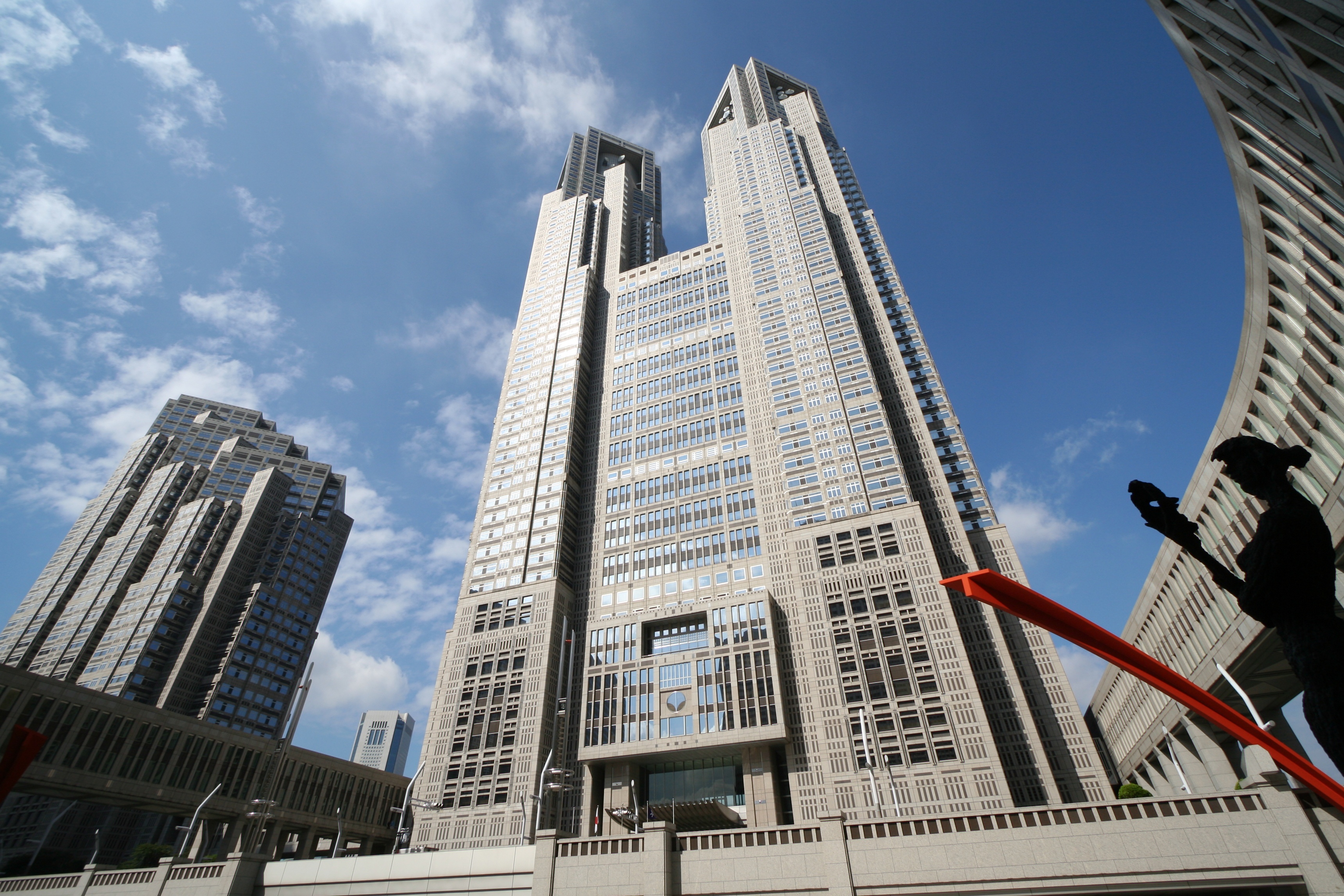
Shinjuku is not one neighborhood but a mosaic. Kabukicho, Tokyo's famous red-light district near Seibu-Shinjuku Station, pulses with bars, restaurants, and neon signage. Shinjuku Ni-chome, a few blocks south, holds the world's highest concentration of gay bars. Nishi-Shinjuku, the area west of the station, is a forest of skyscrapers anchored by the Tokyo Metropolitan Government Building, where the governor's office and metropolitan assembly relocated from Marunouchi in 1991. The 58.3-hectare Shinjuku Gyoen blends Japanese, English landscape, and French formal gardens on the grounds of the old Naito estate. Okubo, near Shin-Okubo Station, is Tokyo's historic ethnic Korean neighborhood. Kagurazaka, on a hill descending toward Iidabashi, was once one of Tokyo's last remaining geisha districts and now hosts a sizable French community. Totsuka, surrounding Waseda University and Takadanobaba Station, thrums with student nightlife. The ward holds 355,981 residents within its boundaries, but the daily population -- workers, commuters, tourists pouring through Shinjuku Station's 3.64 million daily passages -- dwarfs that figure many times over.
From Firebombing to Fukutoshin
The Tokyo air raids of 1945 destroyed almost 90 percent of the buildings in and around Shinjuku Station. Only in Kabukicho was a grand reconstruction plan carried out; elsewhere, the surviving roads and rail lines dictated the post-war street grid. The present ward was established on March 15, 1947, from the merger of the former wards of Yotsuya, Ushigome, and Yodobashi. In 1964, marathon and 50-kilometer walk courses for the Summer Olympics passed through its streets. A year later, the Yodobashi Water Purification Plant -- the city's first modern water treatment facility, built in 1898 -- closed, and skyscrapers rose on its former grounds. By the time the Tokyo Metropolitan Government moved its headquarters to Nishi-Shinjuku in 1991, the ward had fully earned its designation as Tokyo's fukutoshin -- its secondary center. The word acknowledges what Shinjuku has always been: not the old capital, but the restless second city that grew up on solid ground while the first one kept shaking.
From the Air
Located at 35.701N, 139.710E in central-western Tokyo. From altitude, Shinjuku ward is identifiable by the distinctive cluster of high-rise towers in Nishi-Shinjuku, including the twin towers of the Tokyo Metropolitan Government Building -- the tallest structure in the group. The large green rectangle of Shinjuku Gyoen park (58.3 hectares) is a prominent landmark to the east of the skyscraper district. The ward sits approximately 10 nautical miles north-northwest of Tokyo Haneda International Airport (RJTT) and 35 nautical miles west of Narita International Airport (RJAA). At 3,000-5,000 feet AGL, the contrast between the Nishi-Shinjuku towers and the lower-rise residential areas to the north and east is clearly visible.