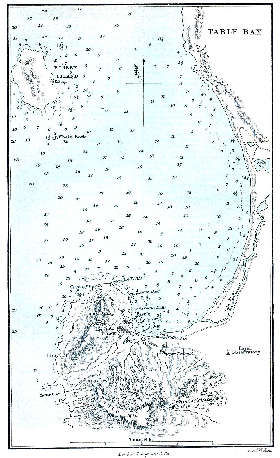
Shipwrecks of Cape Town
Table Bay looks inviting from above -- a broad sweep of blue water curving gently toward the flat-topped mountain that gives Cape Town its silhouette. But the beauty is deceptive. Northwest gales funnel into the bay with ferocious regularity, snapping anchor cables and driving ships onto reefs and beaches with a consistency that has made these waters among the most wreck-littered in the world. For over four hundred years, from the earliest European exploration of the southern tip of Africa, ships have been dying here.
The Bay That Eats Ships
The pattern established itself early. In July 1618, the French jacht Jaeger was wrecked near Woodstock beach during a northwest gale -- one of the earliest recorded losses in Table Bay. The problem was structural: Table Bay offers shelter from the prevailing southeasterly winds that blow in summer, but it lies wide open to the northwest winter storms that barrel in off the Atlantic. Ships at anchor had no escape. When the wind shifted and the swells built, crews could only watch their cables strain and pray they held. Many did not. The bay's sandy bottom provided poor holding ground, and one dragged anchor could set off a chain reaction as drifting vessels fouled each other's rigging.
Ghosts Under Reclaimed Land
Some of Cape Town's shipwrecks are not underwater at all. The British ship Woodbridge, wrecked in Table Bay in 1816, now lies beneath reclaimed land -- her timbers entombed in the foundations of the modern city. The same fate befell the convict transport Waterloo, which parted her anchor cables and ran aground on Salt River beach in 1842. As Cape Town's harbor expanded and the shoreline pushed outward, wreck after wreck was simply built over. The city's waterfront -- where tourists sip wine and browse craft markets -- sits atop a graveyard of wooden hulls. Walking through the V&A Waterfront, you tread on layers of maritime catastrophe without knowing it.
Mistaken Identity at Chapman's Peak
Not all wrecks came from storms. The 665-ton steamship Kakapo ran aground on Noordhoek beach in May 1900 for one of the oldest reasons in seafaring: the watch mistook one headland for another. In heavy rain and a northwesterly gale, the crew confused Chapman's Peak with Cape Point and turned too early, driving the ship onto a sandy beach from which she could never be refloated. Her boilers rusted on that beach for decades, a landmark for hikers and surfers. The wreck of the Kakapo is a reminder that the Cape Peninsula's similar-looking headlands, shrouded in rain and cloud, could deceive even experienced navigators.
The Leviathan on Whale Rock
The scale of wreckage grew with the ships. On 30 March 1986, the Korean bulk carrier Daeyang Family -- 96,760 gross registered tons, loaded with 180,000 tons of iron ore -- dragged her anchors in a storm and went aground on the reef at Whale Rock, south of Robben Island. Her hull held together until the great gale of 1994 finally broke her apart. Today her debris covers an area roughly 500 meters by 400 meters on the seafloor of Table Bay. The initial salvage focused on removing 630,000 liters of oil before it could devastate the coastline. Far from the age of sail, the Daeyang Family proved that modern steel and modern technology could not conquer the same storms that had been sinking ships in Table Bay since the 1600s.
Diving the Graveyard
Today these wrecks draw a different kind of visitor. Scuba divers explore the remains scattered across False Bay and the Cape Peninsula's Atlantic coast, swimming through engine rooms and cargo holds that storms and time have pried open. The crystal-clear waters on calm days reveal wreckage spanning centuries of maritime technology: the wooden ribs of sailing ships, the iron boilers of early steamers, the steel plates of modern freighters. Each wreck tells a story of ambition meeting geography -- of the trade routes that made Cape Town essential, and the winds and currents that made it lethal. South Africa's National Heritage Resources Act now protects many of these sites, preserving them as an underwater museum that chronicles four centuries of the struggle to round Africa's southwestern corner.
From the Air
Cape Town and Table Bay are centered around 33.9S, 18.4E. From altitude, Table Bay's crescent shape is clearly visible with Table Mountain as a prominent landmark to the south. Cape Town International Airport (FACT) lies to the east. The Cape Peninsula extends southward, with False Bay to the east and the Atlantic to the west. Numerous wreck sites are scattered throughout Table Bay, along the Atlantic coast, and in False Bay.