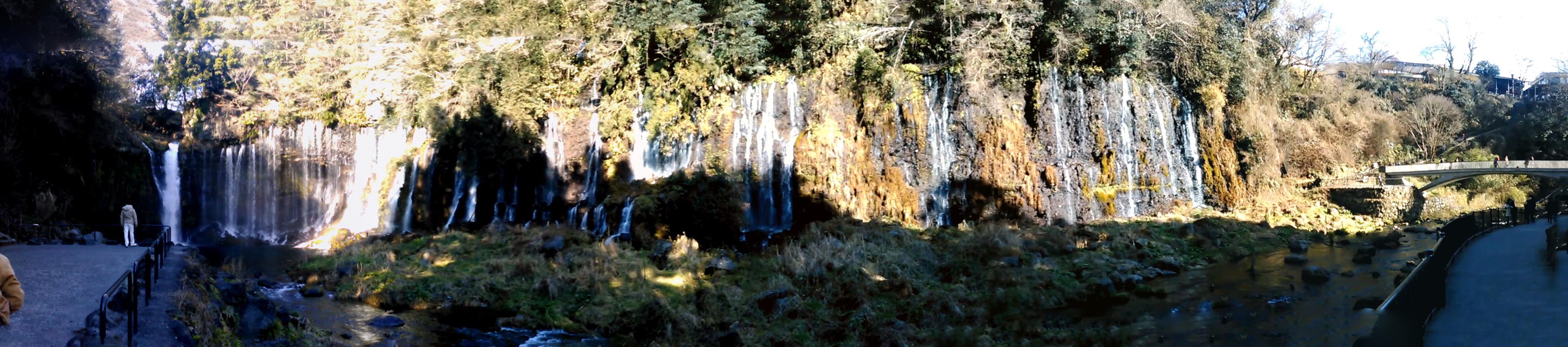
Shiraito Falls
The name means "white threads," and standing at the base you understand immediately. Hundreds of individual streams spill over a curved cliff face 150 meters wide and 20 meters tall, each one a thin, luminous strand of water falling through air. Unlike most waterfalls, Shiraito is not fed by a river tumbling over a ledge. Almost all of its water seeps directly from the porous volcanic rock of Mount Fuji's southwestern flank -- snowmelt and rain filtered through layers of lava over decades, emerging here at a constant 12 degrees Celsius year-round. An estimated 1.5 tons of spring water flows every second, and the result is less a waterfall than a living curtain, an arc of silk draped across the forest.
Fuji's Hidden Plumbing
Mount Fuji is an enormous sponge. Rain and snowmelt percolate through its layers of porous volcanic rock, traveling underground for years before resurfacing at springs around the mountain's base. Shiraito Falls is one of the most dramatic of these outlets. The water does not arrive via a stream or river above the cliff; it pushes straight through the rock face itself, emerging from countless fissures along the entire width of the curved basalt wall. This is what gives the falls their distinctive appearance -- not a single torrent but hundreds of delicate threads, fanning outward in a gentle arc. A five-minute walk away, the Otodome Falls present a sharp contrast: a single, more conventional cascade dropping 25 meters from a concentrated point, fed by the Shiba River.
Cold Water and Burning Faith
From the late Sengoku period into the early Edo era, the falls served as a training ground for the devout. Hasegawa Kakugyo, the founder of the Fujiko sect -- a religious movement centered on the worship of Mount Fuji -- is said to have performed ascetic practices in the freezing water here, alongside his training at the Hito-ana lava cave. His followers continued the tradition. During the Edo period, pilgrim monks bathed in the cascades as a test of endurance before attempting the climb to Fuji's summit, reasoning that if they could withstand the cold at the base, the dropping temperatures at altitude would be more bearable. Drawings made by Fujiko believers in the eighteenth century depict these waterfall ablutions, and stone monuments marking the practice sites still stand among the rocks today.
A Century of Recognition
Japan has been cataloguing its scenic wonders with characteristic thoroughness. In 1927, the Tokyo Nichi Nichi Shimbun and Osaka Mainichi Shimbun selected Shiraito Falls as one of the 100 Landscapes of Japan. In 1936, the falls received protection as a Japanese Natural Monument within the Fuji-Hakone-Izu National Park. In 1990, the Ministry of the Environment named them one of Japan's Top 100 Waterfalls. And in 2013, UNESCO inscribed the falls as part of the Fujisan Cultural Site, recognizing their role not merely as natural scenery but as a place where the spiritual relationship between Japanese people and their most sacred mountain was physically enacted through ritual and pilgrimage.
Threads That Connect
The walk from the parking area descends through forest along the Shiba River gorge, the sound of water building gradually before the falls appear around a final bend. In autumn, the white threads fall against a backdrop of red and gold maples. In winter, ice crystals form along the cliff edges, framing the streams in frozen lace. On clear days, the summit of Mount Fuji rises behind the treeline above the falls, connecting the water at your feet to the snow at the peak in a single unbroken visual line -- the same water, making the same journey it has made for centuries, from cloud to summit to rock to these white threads hanging in the air.
From the Air
Located at 35.3125N, 138.5889E on the southwestern flank of Mount Fuji, within Fuji-Hakone-Izu National Park. The falls are nestled in a forested gorge and not directly visible from altitude, but the Shiba River valley and surrounding forest clearing can be identified. The nearby Otodome Falls are a five-minute walk to the east. Recommended viewing altitude: 2,000-4,000 feet for terrain context. Nearest airports: Mt. Fuji Shizuoka Airport (RJNS) approximately 30nm southeast, Chofu Airport (RJTF) approximately 55nm east. Best visibility in morning hours before orographic clouds build around Fuji.