Shirakawa Barrier
When the poet Matsuo Basho reached the Shirakawa Barrier in June of 1689, he was so overwhelmed that he could not write. Asked later what haiku he had composed at the famous crossing, he admitted he had been too moved by the scenery and too exhausted from travel to put brush to paper. This was the gate through which his masterwork, The Narrow Road to the Deep North, truly began -- the threshold between the familiar provinces of central Japan and the remote, mysterious Tohoku region to the north. "For the first time," Basho wrote, "I felt that our journey had truly begun." The barrier itself had been in ruins for centuries by the time he passed through, but its power as a literary symbol -- an utamakura, a place name encoded with poetic meaning -- made the crossing feel as significant as it had been a thousand years earlier, when armed guards stood watch over the frontier of the Yamato state.
The Edge of the Known World
The Shirakawa Barrier was one of three frontier fortifications built during the Nara period to mark the border between the territory controlled by the Yamato state and the Emishi, the indigenous tribes of northern Honshu. Archaeological evidence suggests the barrier may actually date even further back, to the latter half of the fifth century during the Kofun period. Its first appearance in written records is dated December 3, 835 AD, and that document mentions the barrier as already being four hundred years old. For centuries, it served a dual purpose: a military fortress guarding against Emishi incursions from the north, and a checkpoint regulating the movement of people and goods between the central provinces and the frontier. It sat on the Oshu Kaido, the great highway running from Edo northward through the mountains of Fukushima, in what is now the Hatajuku neighborhood of Shirakawa city, three kilometers south of the Tochigi Prefecture border.
From Fortress to Poetry
By the early Heian period, the Yamato forces had gradually conquered the Emishi, and the barrier lost its military purpose. It fell into disrepair and had largely vanished by the start of the Kamakura period in the late twelfth century. But as the physical structure crumbled, its literary afterlife was just beginning. Japanese poets adopted Shirakawa as an utamakura -- a place name that carried coded meaning in verse. To invoke Shirakawa in a poem was to evoke distance, transition, loneliness, and the bittersweet act of leaving the known for the unknown. Generations of poets who had never seen the barrier wrote about crossing it. The place became more powerful as an idea than it had ever been as a fortification. When Basho finally stood at the site in 1689, he was walking through a landscape already thick with centuries of accumulated poetic meaning, a place where the physical and the literary had become inseparable.
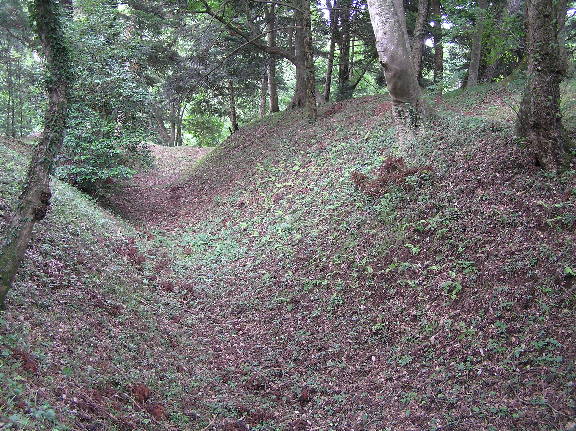
Lost and Found
For centuries, nobody knew exactly where the barrier had stood. The fortification had dissolved back into the forested hills of southern Fukushima, and the precise location became a matter of scholarly debate. In 1800, Matsudaira Sadanobu, the daimyo of Shirakawa Domain and a noted reformer, undertook a study of ancient texts to pin down the site. He succeeded, identifying the location through painstaking cross-referencing of historical documents. Sadanobu marked the spot with a stone monument and ordered the construction of a Shinto shrine, the Shirakawa Jinja, to consecrate the rediscovered ground. More than 150 years later, professional archaeologists arrived. Excavations conducted between 1956 and 1963 uncovered the physical evidence that confirmed Sadanobu's identification: the remains of a dry moat, a double wooden palisade, earthen ramparts, and the foundations of pit dwellings and blacksmith workshops -- the infrastructure of a working military outpost that had stood guard on the frontier for centuries.
Where the Barrier Stands Today
The site was designated a National Historic Site in 1966 and is now part of Shirakawa Seki-no-mori Park, a landscaped preserve that contains a reconstructed ancient house and several preserved old farmhouses relocated to the grounds. The park sits in a forested setting that gives some sense of how remote this frontier must have felt to travelers arriving from the south, though modern Shirakawa city is a small but comfortable urban center just to the north. The archaeological remains are subtle -- earthen contours and grassy depressions rather than standing walls -- but they are real, and standing among them brings the layered history of the site into focus. This is a place where fifth-century warriors watched the tree line for enemies, where Nara-period officials checked travel documents, where Heian poets found metaphors for the human condition, and where Basho paused, overwhelmed, at the start of his greatest journey.
From the Air
Located at 37.05N, 140.23E in the southern portion of Fukushima Prefecture, three kilometers south of the Tochigi Prefecture border. The site occupies a forested hillside area along the historic Oshu Kaido highway route. From the air, look for the Shirakawa Seki-no-mori Park clearing amid forested hills south of Shirakawa city. Nearest airports: Fukushima Airport (RJSF) approximately 40nm north, Utsunomiya (RJTU) approximately 55nm south. The Tohoku Shinkansen corridor runs nearby through Shin-Shirakawa Station. Mountainous terrain with elevations around 400-600m. Visibility generally good except during winter snow events common to the region.