Shotover River
The Maori called it Kimiakau - "looking for the coast" - because the river valley served as a route through the mountains to the West Coast and the pounamu, the precious greenstone, that could be found there. Scottish pioneers Donald Angus Cameron and Angus Alphonse Macdonald called it the Tummel, after a river back home. Then William Gilbert Rees arrived in 1860, settled on the shores of Lake Wakatipu, and renamed it Shotover - not because the water shoots over anything in particular, but because his business partner George Gammie owned an estate called Shotover Park in England. The river has outlasted all three names, though only the most recent stuck. It has also outlasted the gold that made it famous, the miners who tore up its banks, and the brothers who tried to redirect its entire course through a tunnel in solid rock.
The Richest River
When Thomas Arthur discovered gold at what became Arthurs Point in 1862, the Shotover earned a reputation as one of the richest gold-bearing rivers in the world. The claim was not exaggeration. Arthur himself extracted 200 ounces - nearly six kilograms - in just eight days. The news turned Queenstown from a pastoral settlement into a boomtown practically overnight. For the next several decades, the Shotover was panned, cradled, sluiced, and dredged by thousands of miners working every accessible beach along its 75-kilometre length. Two tributaries, Moke Creek and Moonlight Creek, yielded their own gold. The river runs south from the Southern Alps through Skippers Canyon, draining the terrain between the Richardson and Harris mountain ranges before joining the Kawarau River east of Queenstown. Along much of that course, it flows through gorges so steep and narrow that reaching the water required ropes, ladders, or a willingness to scramble down rock faces. The gold is still there, in diminished quantities, and small-time prospectors still work the gravels today.
The Tunnel That Failed
The Oxenbridge brothers - Bert and Ned, along with their nephew Victor - arrived from Australia with a plan that was either visionary or delusional, depending on whom you asked. They would bore a 170-metre tunnel through the solid rock bluff at Arthurs Point, divert the Shotover River through it, and mine the gold from the exposed riverbed. The tunnel was completed. A dam was built to back the water through it. The day after the dam was finished, a flood swept it away. Even when the diversion partially worked, a calculation error meant the tunnel sat too high to fully drain the river. And when sections of the riverbed were finally exposed, little gold was found. The scheme was abandoned, leaving behind a Category II Historic Place that today serves as a passage for rafters and kayakers rather than a monument to engineering triumph. The Department of Conservation maintains a walking track from the Edith Cavell Bridge along the river to the tunnel - a pleasant stroll through the wreckage of someone else's ambition.
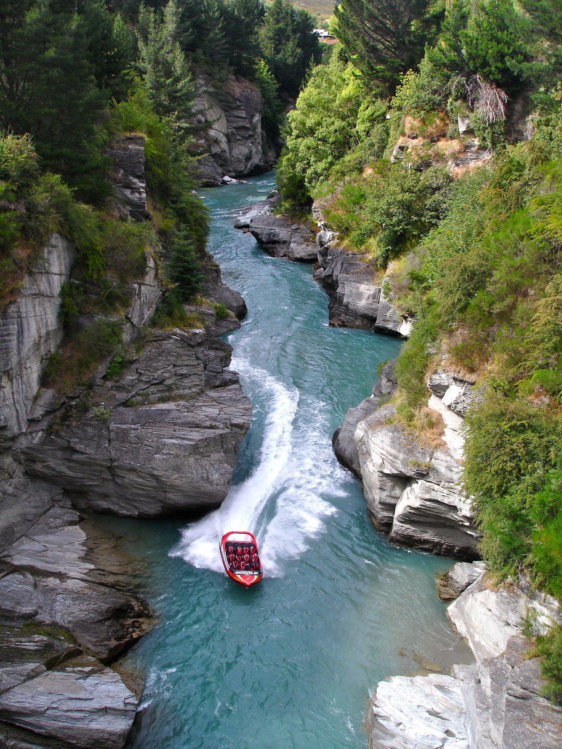
From Gold Pans to Jet Boats
The Shotover's second life began when the gold ran thin and tourism filled the gap. Queenstown reinvented itself as an adventure capital, and the river that had once attracted prospectors now attracted thrill-seekers. Commercial jet boat operators send their vessels screaming through the narrow canyon at high speed, executing 360-degree spins just metres from the rock walls - a quintessentially New Zealand experience invented by the same Bill Hamilton who built the first ski lift at nearby Coronet Peak. White water rafting companies run the rapids, and a canyon swing site near Arthurs Point offers the chance to leap into the void above the river. The old lower Shotover bridge, built in 1915 on tall concrete piers and stretching 172.5 metres across the river, was replaced for vehicle traffic in 1975 but restored in 2004 as part of the Queenstown Trail cycling and walking network. Much of the land upstream from Arthurs Point is now privately owned by Robert Lange, the former husband of singer Shania Twain - a detail that amuses locals and bewilders visitors in roughly equal measure.
When the River Freezes
The Shotover's cold-weather extremes are as dramatic as its rapids. In July 1991, the river froze bank to bank near Skippers Canyon - a solid sheet of ice spanning a river that normally churns with enough force to flip a raft. It froze again in June 1992. In July 2007, car-tyre-sized blocks of ice came floating down the channel and disrupted the jet boat and rafting operations that depend on the river being liquid and navigable. In 2012, large stretches froze solid once more after a sustained cold snap. These events are reminders that the Shotover, for all its commercial reinvention, remains a river governed by the Southern Alps' weather rather than by the tourism schedules of Queenstown. The same glacial origins that give the water its pale jade color also mean that when winter bites hard enough, the river simply stops moving. It is a landscape that does not negotiate.
From the Air
The Shotover River is located at approximately 44.81S, 168.74E, flowing 75 km from the Southern Alps south through Skippers Canyon before joining the Kawarau River east of Queenstown. From the air, the river is visible as a pale jade ribbon cutting through steep gorges, with the braided channels and gravel bars clearly identifiable. Arthurs Point, where gold was first discovered, sits where the river emerges from the canyon. The Edith Cavell Bridge is a visible crossing point. Queenstown Airport (NZQN) is approximately 8 km to the southwest. The surrounding terrain includes Coronet Peak (1,649 m) to the north and The Remarkables range to the southeast. Mountain weather can change rapidly; expect turbulence in the canyon. Best viewed at 4,000-6,000 feet AGL.