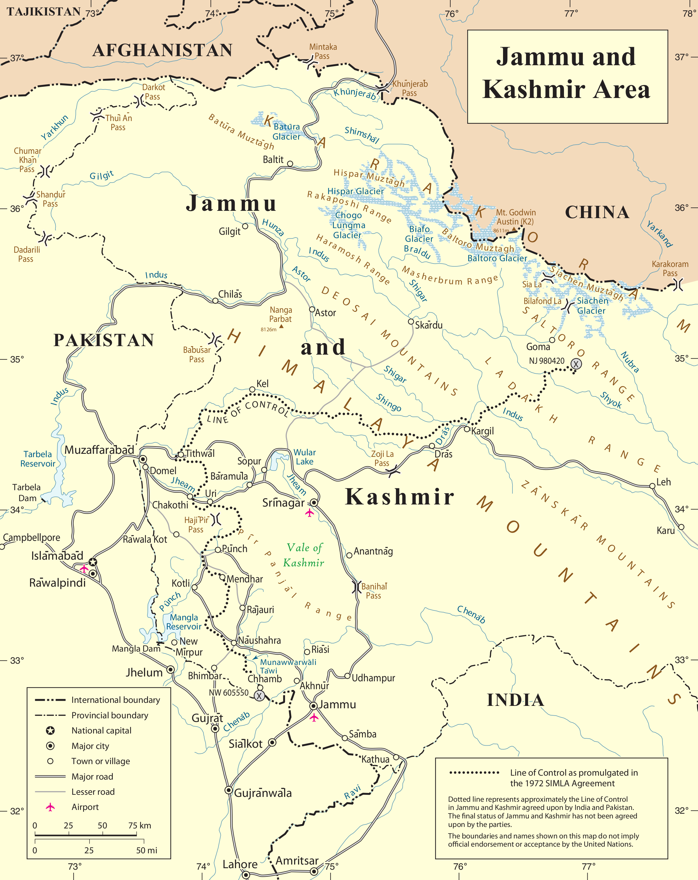
Siachen Glacier
In the Balti language, "sia" means rose and "chen" means abundance. The Siachen Glacier -- 76 kilometers of ice cascading from 5,753 meters at Indira Col down to 3,620 meters at its terminus -- was named for the wild rose plants that once flourished across the region. It is the longest glacier in the Karakoram and the second longest in the world outside the polar regions. Since 1984, it has also been the highest battlefield on Earth, a place where more soldiers have died from cold, altitude, and avalanche than from enemy fire. Before the armies arrived, no one lived here at all.
The Third Pole
Siachen lies in the eastern Karakoram, in the region sometimes called the Third Pole for its vast concentration of glacial ice. The glacier sits between the Saltoro Ridge to the west -- its peaks rising from 5,450 to 7,720 meters -- and the main Karakoram range to the east. Three major passes cross the Saltoro Ridge: Sia La at 5,589 meters, Bilafond La at 5,450 meters, and Gyong La at 5,689 meters. Average winter snowfall exceeds ten meters. Temperatures plunge so far below zero that the cold itself becomes a kind of terrain, shaping what is possible and what is not. Including all its tributaries, the Siachen system covers roughly 700 square kilometers of ice -- a frozen watershed whose meltwater feeds the Nubra River, which flows into the Shyok, which joins the 3,000-kilometer Indus, sustaining the largest irrigation system in the world.
A Line That Stopped Too Soon
The 1949 Karachi Agreement drew a ceasefire line between India and Pakistan that ended at a coordinate called NJ9842, after which the document stated only that the line would continue "thence north to the glaciers." Nobody thought the frozen wastes beyond that point were worth fighting over. For three decades, nobody did. Then, in the 1970s and 1980s, American and Pakistani maps began drawing a dotted line from NJ9842 to the Karakoram Pass, implicitly placing the glacier on Pakistan's side. India considered this a cartographic violation of the Simla Agreement. In April 1984, India launched Operation Meghdoot, airlifting troops to seize the passes of the Saltoro Ridge just one day before Pakistan's own operation was set to begin. India secured Sia La, Bilafond La, and Gyong La. The glacier and its heights have remained under Indian control ever since.
The Cost of Altitude
The numbers are staggering and grim. By 2016, 869 Indian soldiers had died on the Siachen Glacier -- not from Pakistani bullets, but from the environment itself. Only 220 Indian deaths since 1984 have been attributed to enemy fire. Pakistan lost 353 soldiers between 2003 and 2010 alone, including 140 killed in the 2012 Gayari Sector avalanche, when a wall of snow buried an entire battalion headquarters. The nearest civilian settlement is the village of Warshi, ten miles downstream from India's base camp. Roads reach only as far as the military post at Dzingrulma, 72 kilometers from the glacier's head. Everything beyond that point -- food, fuel, ammunition, medicine -- must be helicoptered in or carried on the backs of soldiers acclimatizing to altitudes where the oxygen content of air is roughly half what it is at sea level.
Roses Buried Under Waste
Before 1984, the Siachen region was uninhabited and ecologically intact. Four decades of military occupation have changed that. Indian forces alone generate approximately 1,000 kilograms of waste daily, much of it dumped into glacial crevasses. Forty percent is plastic and metal, laced with toxins -- cobalt, cadmium, chromium -- that eventually leach into the Shyok and Indus rivers, used downstream for drinking water and irrigation. The glacier has been retreating at roughly 110 meters per year. Satellite imagery shows it has shrunk by approximately 35 percent, and projections suggest it could be reduced to one-fifth of its 2011 size by 2035. Chemical blasting to build camps, oil pipelines laid inside the glacier to supply kerosene and aviation fuel, and a temperature rise estimated at 0.2 degrees Celsius annually have all accelerated the damage. Environmentalists and peace activists have proposed declaring the region a Siachen Peace Park, endorsed by the International Mountaineering Federation and the IUCN, but the military standoff continues.
Stalemate at the Roof of the World
Both nations have expressed a desire to disengage. India's position is consistent: it will not withdraw until the 110-kilometer Actual Ground Position Line is formally authenticated, delineated, and demarcated -- a demand Pakistan has resisted because it would formally acknowledge Indian control. The Kargil War of 1999 reinforced India's reluctance; having been surprised once, it will not risk a vacuum. Prime Minister Manmohan Singh became the first Indian leader to visit Siachen; Narendra Modi followed. Pakistan's President Zardari visited the nearby Gayari Sector with his army chief, both pledging resolution. Since 2007, India has opened the area to limited mountaineering and trekking expeditions, partly as a demonstration that its troops hold the dominating heights. The wild roses that gave the glacier its name still grow in the lowland villages nearby, tended by Balti families who use their bark to brew butter tea. On the glacier itself, the only things growing are the military installations that neither side can afford -- financially, strategically, or humanly -- but neither side will abandon.
From the Air
Siachen Glacier is located at approximately 35.20N, 77.20E in the eastern Karakoram, extending 76 km from Indira Col (5,753m) on the India-China border southward to its terminus at 3,620m. The glacier is visible from high altitude as a massive white ribbon between the Saltoro Ridge to the west and the main Karakoram range to the east. This is restricted military airspace for both India and Pakistan -- overflight requires special clearance. The nearest significant airfield is Thoise (ICAO: VITH), used primarily by the Indian Air Force to supply Siachen operations. Leh Airport (ICAO: VILH) is the nearest civilian airport. Extreme high-altitude conditions with severe turbulence, unpredictable weather, and oxygen-thin air above 5,000m.