Siege of Ngatapa
The hilltop pa at Ngatapa had one apparent advantage and one fatal flaw. The advantage was its position: an 800-meter rise above a ridge, with the northern face a near-vertical precipice, the southern side steep and choked with bush, and the western approach a knife-edge ridge. The flaw was that there was no water inside the walls. When Colonel George Whitmore and nearly 700 men -- Armed Constabulary and Ngati Porou warriors under the formidable Ropata Wahawaha -- encircled the pa at the end of December 1868, the 500 people trapped inside had days, not weeks, before thirst would decide the outcome. What happened next, over six days bridging the old year and the new, would be remembered as both a military defeat and a massacre.
Exile, Escape, Revenge
Te Kooti was a warrior of the Rongowhakaata iwi who in 1865 had fought on the government's side against the Pai Marire movement. His reward was suspicion. Accused of spying on the basis of intercepted correspondence, he was arrested by Major Reginald Biggs and exiled without trial to the Chatham Islands in June 1866, along with Pai Marire warriors and their families. During two years of captivity, he developed his own faith, Ringatu, and gathered a following among the dispossessed. In 1868, they commandeered a vessel and escaped, landing armed at Poverty Bay in July. When Major Biggs demanded surrender, Te Kooti refused. The local militia pursued him inland, and each engagement went badly for the Europeans. Te Kooti acquired weapons and supplies with every victory. By November, his grievances had hardened into action. On the night of 9 November, his forces attacked settlements across Poverty Bay, killing settlers, their families, and Maori aligned with the government. Among the dead were Major Biggs, his wife, and their infant son.
The Fortress with No Water
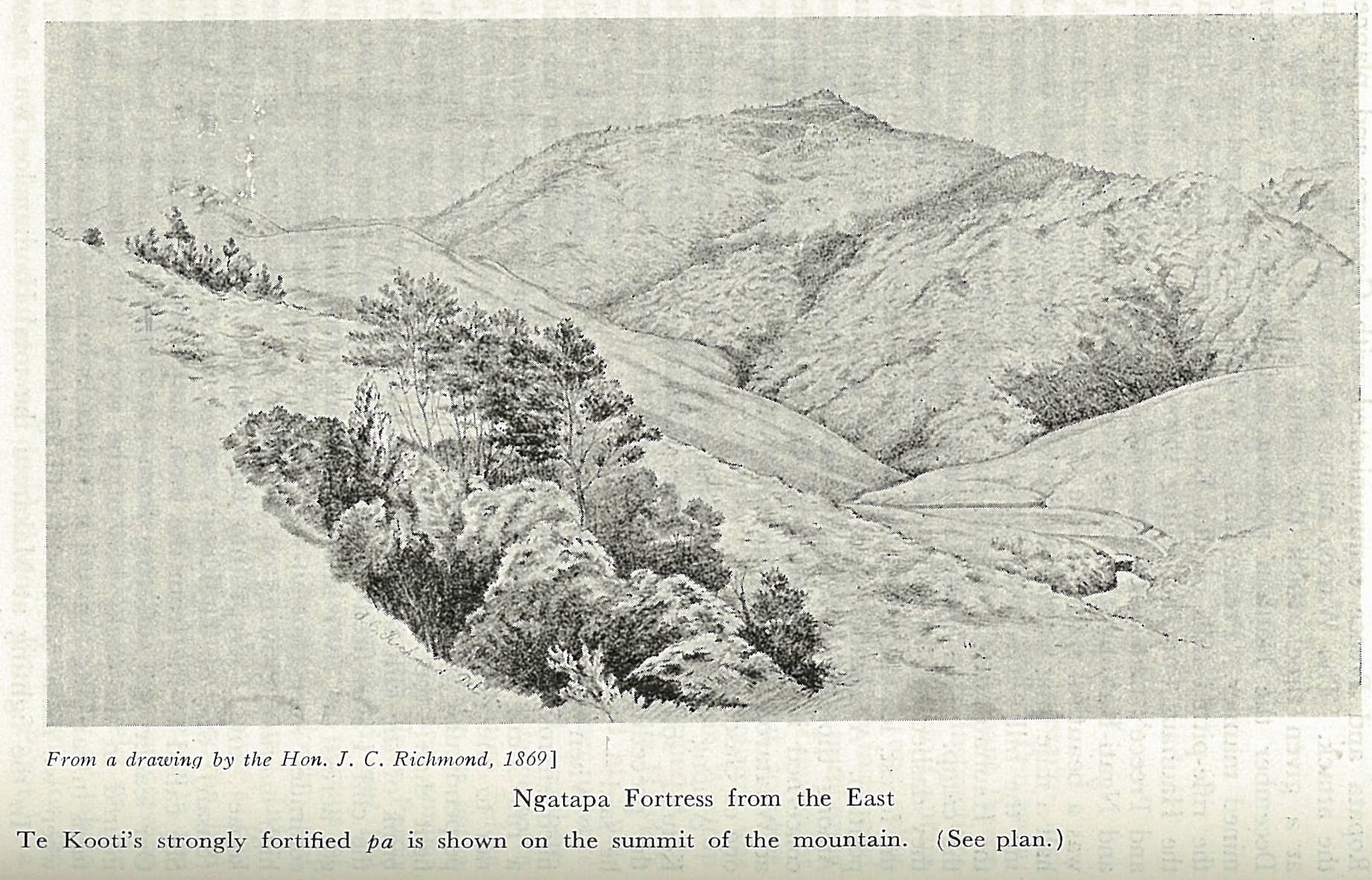
After withdrawing from Poverty Bay with captives and supplies, Te Kooti fortified the pa at Ngatapa, roughly 56 kilometers from the coast. He had strengthened it with three concentric trenches, earth banks, palisades, covered walkways, and a maze of rifle pits. But the historian James Belich observed that Ngatapa was more a traditional pa than a modern one. The parapets were too wide, creating blind spots at close range. Te Kooti had neglected traps and diversions. Most critically, the pa had no internal water source -- a serious problem when the defenders numbered around 300 warriors plus families and prisoners, at least 500 people in all. A first assault on 4 December by Ropata's Ngati Porou warriors breached the outer trench but was abandoned when ammunition ran out. The kupapa withdrew to Turanga to resupply and regroup.
Encirclement
Whitmore returned with a larger, better-supplied force on 24 December, establishing Fort Richmond about five kilometers from the pa. On 30 December, Ropata arrived with 300 fresh Ngati Porou warriors, bringing Whitmore's total strength to nearly 700. The following day they advanced to the Crow's Nest, a secondary hill 800 meters east of Ngatapa, and began digging in under sniper fire. Detachments worked around the base of the hilltop, cutting off every approach, every water source, every pathway down the slopes. Boulders rolled by the defenders crashed through the bush toward the men below. By early January, the pa was sealed on all sides -- except the northern precipice, a sheer rock face that no commander would consider a viable escape route. Heavy rain delayed the final assault and strained Whitmore's supply lines, but also denied the defenders any relief. On 3 January, desperate Ringatu warriors sortied against the western perimeter. Whitmore answered with Coehorn mortars. On 4 January, Ngati Porou and Te Arawa fighters scaled the steep southern slope and stormed the outer trench.
Down the Impossible Cliff
In the early hours of 5 January 1869, Te Kooti and his surviving fighters did what no one expected. They descended the northern cliff face -- lowering themselves more than 20 meters on ropes woven from vines -- and vanished into the gorges below. When the attackers entered the pa at dawn, they found mainly women, children, and wounded men. The wounded were killed immediately. Te Kooti and his key followers had escaped, but around 130 of his fighters were too weak from hunger and too short of ammunition to evade the pursuit that followed. Ropata's Ngati Porou and Te Arawa constabulary tracked them through the bush over two days. Most of the captured men were marched to a cliff edge and executed on Ropata's orders. Whitmore, present and aware, did nothing to intervene. The historian Matthew Wright noted that Ropata himself had been captured and enslaved by Te Kooti's Rongowhakaata iwi as a young man. Some of those executed may not have been Ringatu fighters at all, but Maori whom Te Kooti had taken prisoner during his raids.
The Horrors Answered Horrors
Te Kooti escaped into the Urewera ranges, where the Tuhoe sheltered him. He raided government-aligned Maori communities for years, evading every expedition sent after him. Eventually, the punitive campaigns into Tuhoe territory eroded his support, and he moved to the King Country under the protection of Tawhiao, the Maori King. He received a pardon in 1883. The reckoning took longer. In 2004, the Waitangi Tribunal described the executions at Ngatapa as 'one of the worst abuses of law and human rights in New Zealand's colonial history.' It also noted that Te Kooti's killings in Poverty Bay breached the Treaty of Waitangi, and offered a summation that refuses to assign all the guilt to one side: 'The horrors of Ngatapa were perpetrated to avenge the horrors of Matawhero.' On 5 January 2019, 150 years after the massacre, descendants of those killed unveiled a pouwhenua -- a carved totara land post -- near Matawhero. Memory, in this landscape, is not passive. It is carved into wood and planted in the ground.
From the Air
Ngatapa (38.51S, 177.56E) is a hilltop site in the rugged hill country approximately 56 km northwest of Gisborne (Turanga), in the East Coast region of New Zealand's North Island. The pa sat atop an isolated hilltop rising from a ridge, with steep bush-covered slopes and a sheer northern cliff. The terrain is rough and hilly, with few flat areas. Gisborne Airport (NZGS) lies approximately 50 km to the southeast. The surrounding landscape is pastoral hill country with pockets of native bush. Recommended viewing altitude: 2,000-4,000 ft AGL to see the ridgeline and gorge terrain.